Difference between revisions of "2012-06-03 52 4"
imported>Murfie (→Plans) |
imported>FippeBot m (Location) |
||
| (4 intermediate revisions by 2 users not shown) | |||
| Line 1: | Line 1: | ||
| − | |||
<!-- If you did not specify these parameters in the template, please substitute appropriate values for IMAGE, LAT, LON, and DATE (YYYY-MM-DD format) | <!-- If you did not specify these parameters in the template, please substitute appropriate values for IMAGE, LAT, LON, and DATE (YYYY-MM-DD format) | ||
| Line 32: | Line 31: | ||
== Expedition == | == Expedition == | ||
| − | + | First drawback was that the destination road was not available in my car navigation. | |
| + | So I entered a nearby road in my navigator and drove there. | ||
| + | The geohash was shown to be located on a parking lot near a large sporting area. | ||
| + | |||
| + | About 800m from the destination, the second unexpected event came up. | ||
| + | I encountered a sign, telling the road was closed. | ||
| + | This was because there was some kind of run for charity going on. | ||
| + | |||
| + | There were two options now: | ||
| + | Go back and chose another road, or park and walk the rest. | ||
| + | |||
| + | I chose the latter. | ||
| + | During this walk I crossed some kind of familily event on a large grass field, which | ||
| + | was probably around the finish line of the run. | ||
| + | |||
| + | The walk to the geohash was a very nice one. There's a beautiful quiet park around the | ||
| + | sporting facilities and although the clouds looked if it was going to rain any time, | ||
| + | I kept it dry during the whole walk. | ||
| + | |||
| + | Hardly had I visited the final spot, or a girl came walking to the same spot from | ||
| + | the opposite direction. I thought she was geohashing too and that this was | ||
| + | a highly unlikely coincidence. However, she was just looking for the finish line of | ||
| + | the running event, where she was to meet a friend. I was the only one around at that | ||
| + | moment, so she walked up to me to ask where to go. I was a bit disappointed and not | ||
| + | familiar in the area, and although I expected it was at the field I crossed earlier, I told | ||
| + | her frankly she'd better ask somebody else. | ||
| + | |||
| + | Concluding, this was a good trip for a cloudy Sunday afternoon and the geohash was very doable. | ||
== Tracklog == | == Tracklog == | ||
| Line 41: | Line 67: | ||
Image:2010-##-## ## ## Alpha.jpg | Witty Comment | Image:2010-##-## ## ## Alpha.jpg | Witty Comment | ||
--> | --> | ||
| − | <gallery perrow=" | + | <gallery perrow="4"> |
| + | Image:2012-06-03_52_4_alphen1.jpg | car navigation instructed me to go through this 'tunnel' | ||
| + | Image:2012-06-03_52_4_alphen2.jpg | some festival going on nearby | ||
| + | Image:2012-06-03_52_4_alphen3.jpg|quiet road leading up to the geohash | ||
| + | Image:2012-06-03_52_4_alphen4.jpg|quiet and peaceful scene | ||
| + | Image:2012-06-03_52_4_alphen5.jpg|Me, standing at the spot | ||
| + | Image:2012-06-03_52_4_alphen6.jpg|the parking lot | ||
| + | Image:2012-06-03_52_4_alphen7.jpg|Not a very interesting place.. | ||
| + | Image:2012-06-03_52_4_alphen8.jpg|Road is closed for a running event. See runner. Also, somebody wrote 'XD' on the road sign. 2 letters are missing, I guess | ||
| + | |||
| + | |||
</gallery> | </gallery> | ||
| Line 51: | Line 87: | ||
<!-- =============== USEFUL CATEGORIES FOLLOW ================ | <!-- =============== USEFUL CATEGORIES FOLLOW ================ | ||
Delete the next line ONLY if you have chosen the appropriate categories below. If you are unsure, don't worry. People will read your report and help you with the classification. --> | Delete the next line ONLY if you have chosen the appropriate categories below. If you are unsure, don't worry. People will read your report and help you with the classification. --> | ||
| − | [[Category: | + | [[Category:Expeditions]] |
| + | [[Category:Expeditions with photos]] | ||
| + | [[Category:Coordinates reached]] | ||
<!-- Potential categories. Please include all the ones appropriate to your expedition --> | <!-- Potential categories. Please include all the ones appropriate to your expedition --> | ||
| Line 78: | Line 116: | ||
[[Category:Not reached - Did not attempt]] when you went to an alternate location, or decided early on to abort the expedition. | [[Category:Not reached - Did not attempt]] when you went to an alternate location, or decided early on to abort the expedition. | ||
--> | --> | ||
| + | {{land geohash | latitude = 52 | longitude = 4 | date = 2012-06-03 | name = Murfie | image = 2012-06-03_52_4_alphen5.jpg }} | ||
| + | {{location|NL|ZH}} | ||
Latest revision as of 04:22, 13 August 2019
| Sun 3 Jun 2012 in 52,4: 52.1220486, 4.6763580 geohashing.info google osm bing/os kml crox |
Location
Alphen aan den Rijn - East
Participants
Plans
No plan. Just a quick visit during daytime whenever I feel like it. This one can't be that hard.
Expedition
First drawback was that the destination road was not available in my car navigation. So I entered a nearby road in my navigator and drove there. The geohash was shown to be located on a parking lot near a large sporting area.
About 800m from the destination, the second unexpected event came up. I encountered a sign, telling the road was closed. This was because there was some kind of run for charity going on.
There were two options now: Go back and chose another road, or park and walk the rest.
I chose the latter. During this walk I crossed some kind of familily event on a large grass field, which was probably around the finish line of the run.
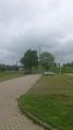
The walk to the geohash was a very nice one. There's a beautiful quiet park around the sporting facilities and although the clouds looked if it was going to rain any time, I kept it dry during the whole walk.
Hardly had I visited the final spot, or a girl came walking to the same spot from the opposite direction. I thought she was geohashing too and that this was a highly unlikely coincidence. However, she was just looking for the finish line of the running event, where she was to meet a friend. I was the only one around at that moment, so she walked up to me to ask where to go. I was a bit disappointed and not familiar in the area, and although I expected it was at the field I crossed earlier, I told her frankly she'd better ask somebody else.
Concluding, this was a good trip for a cloudy Sunday afternoon and the geohash was very doable.
Tracklog
Photos
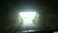
car navigation instructed me to go through this 'tunnel'
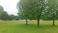
some festival going on nearby
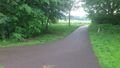
quiet road leading up to the geohash
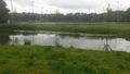
quiet and peaceful scene
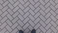
Me, standing at the spot
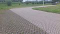
the parking lot
Not a very interesting place..
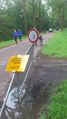
Road is closed for a running event. See runner. Also, somebody wrote 'XD' on the road sign. 2 letters are missing, I guess


Achievements
Murfie earned the Land geohash achievement
|