Difference between revisions of "2012-06-06 42 -88"
imported>RocketMac |
imported>FippeBot m (Location) |
||
| (13 intermediate revisions by 3 users not shown) | |||
| Line 1: | Line 1: | ||
| − | |||
| − | |||
| − | |||
| − | |||
| − | |||
| − | |||
| − | |||
| − | |||
| − | |||
| − | |||
{{meetup graticule | {{meetup graticule | ||
| lat=42 | | lat=42 | ||
| Line 15: | Line 5: | ||
}} | }} | ||
| − | |||
| − | |||
== Location == | == Location == | ||
| − | + | ||
| + | Just outside a parking lot for a (currently) unknown business across from a Super Walmart. It's also right near [http://www.gingerbreadfarmhouse.com The Gingerbread House] which is a coffee and wine bar. If it's in line of sight, I'll officially earn my [[Pub Geohash]] in body not just spirit. | ||
== Participants == | == Participants == | ||
| − | + | ||
| − | + | * [[User:RocketMac|RocketMac]] | |
| + | * [[User:Hezekiah|hezekiah]] | ||
== Plans == | == Plans == | ||
| − | + | ||
| + | === RocketMac === | ||
| + | |||
| + | I'll call The Wyf at lunch and see if she's interested in going with to explore [http://www.gingerbreadfarmhouse.com The Gingerbread House] and if so I'll pick her up and go from there. In which case, we should get there around 7pm. | ||
| + | |||
| + | Otherwise, I'll stop on my way home. In which case I should be there around 6pm. | ||
| + | |||
| + | === Hezekiah === | ||
| + | Hezekiah plans to make the trip down after a late dinner, probably arriving around 9. | ||
== Expedition == | == Expedition == | ||
| − | + | ||
| + | === RocketMac === | ||
| + | I stayed at work a bit later than was anticipated, so my plan to get home and grab The Wyf for a visit to the Gingerbread House was out. Sadly I was most of the way there before I remembered to start my GPS tracker. Again. | ||
| + | |||
| + | Instead I drove to the hashpoint which was right outside an Ace Hardware superstore and wandered around the field which was sloped up from the parking lot until I was confident I had walked through it. I took a few pictures even with the sun stabbing me in the eyes and off I went. | ||
| + | |||
| + | After that it was a quick stop at the grocery story for stir-fry ingredients and then home to a pleasant dinner with wine on the patio. | ||
| + | |||
| + | === hezekiah === | ||
| + | I had to work until 8, meaning I got home around 8:15. Ate some dinner and gathered what little gear I needed, and was on my way. Arrived close to 9:00 PM, headed into the field. Unfortunately, saw no evidence of RocketMac's earlier visit. Did spot a plastic bag (which I [[Geotrash|filled with other garbage]]), and left a rock upright, in case anybody else arrived later. | ||
== Tracklog == | == Tracklog == | ||
| − | + | ||
| + | RocketMac's tracklog is available in [http://coldshadow.com/geohashing/2012-06-06.gpx GPX] and [http://coldshadow.com/geohashing/2012-06-06.kmz KMZ] formats. | ||
== Photos == | == Photos == | ||
| − | < | + | <gallery perrow="4"> |
| − | Image: | + | Image:RocketMac 2012-06-06 42 -88 05.jpg | Stupid Grin |
| − | -- | + | Image:RocketMac 2012-06-06 42 -88 04.jpg | Stupid Grin (w/sun in eyes) |
| − | + | Image:RocketMac 2012-06-06 42 -88 06.jpg | The ACE building | |
| + | Image:RocketMac 2012-06-06 42 -88 07.jpg | WalMart | ||
| + | Image:RocketMac 2012-06-06 42 -88 08.jpg | Gingerbread House is there somewhere | ||
| + | Image:RocketMac 2012-06-06 42 -88 01.jpg | Stupid GPS doesn't track fast | ||
| + | Image:RocketMac 2012-06-06 42 -88 02.jpg | GPS reading | ||
| + | Image:RocketMac 2012-06-06 42 -88 03.jpg | GPS reading | ||
| + | Image:hezekiah 2012_06_06 reached.jpg | GPS | ||
| + | Image:hezekiah 2012_06_06 grin.jpg | Grin | ||
| + | Image:hezekiah 2012_06_06 trash.jpg | Garbage Gatherer Get! | ||
</gallery> | </gallery> | ||
== Achievements == | == Achievements == | ||
| − | |||
| − | |||
| + | {{land geohash | ||
| + | | latitude = 42 | ||
| + | | longitude = -88 | ||
| + | | date = 2012-06-06 | ||
| + | | name = RocketMac | ||
| + | | image = | ||
| + | }} | ||
| + | {{land geohash | ||
| + | | latitude = 42 | ||
| + | | longitude = -88 | ||
| + | | date = 2012-06-06 | ||
| + | | name = Hezekiah | ||
| + | | image = | ||
| + | }} | ||
| − | |||
| − | |||
| − | |||
| − | |||
| − | |||
| − | |||
| − | |||
| − | |||
| − | |||
| − | |||
[[Category:Expeditions]] | [[Category:Expeditions]] | ||
| − | |||
[[Category:Expeditions with photos]] | [[Category:Expeditions with photos]] | ||
| − | |||
| − | |||
| − | |||
| − | |||
| − | |||
[[Category:Coordinates reached]] | [[Category:Coordinates reached]] | ||
| − | + | {{location|US|WI|WK}} | |
| − | |||
| − | |||
| − | |||
| − | |||
| − | |||
| − | |||
| − | |||
| − | |||
| − | |||
Latest revision as of 04:25, 13 August 2019
| Wed 6 Jun 2012 in 42,-88: 42.9283575, -88.1117727 geohashing.info google osm bing/os kml crox |
Contents
Location
Just outside a parking lot for a (currently) unknown business across from a Super Walmart. It's also right near The Gingerbread House which is a coffee and wine bar. If it's in line of sight, I'll officially earn my Pub Geohash in body not just spirit.
Participants
Plans
RocketMac
I'll call The Wyf at lunch and see if she's interested in going with to explore The Gingerbread House and if so I'll pick her up and go from there. In which case, we should get there around 7pm.
Otherwise, I'll stop on my way home. In which case I should be there around 6pm.
Hezekiah
Hezekiah plans to make the trip down after a late dinner, probably arriving around 9.
Expedition
RocketMac
I stayed at work a bit later than was anticipated, so my plan to get home and grab The Wyf for a visit to the Gingerbread House was out. Sadly I was most of the way there before I remembered to start my GPS tracker. Again.
Instead I drove to the hashpoint which was right outside an Ace Hardware superstore and wandered around the field which was sloped up from the parking lot until I was confident I had walked through it. I took a few pictures even with the sun stabbing me in the eyes and off I went.
After that it was a quick stop at the grocery story for stir-fry ingredients and then home to a pleasant dinner with wine on the patio.
hezekiah
I had to work until 8, meaning I got home around 8:15. Ate some dinner and gathered what little gear I needed, and was on my way. Arrived close to 9:00 PM, headed into the field. Unfortunately, saw no evidence of RocketMac's earlier visit. Did spot a plastic bag (which I filled with other garbage), and left a rock upright, in case anybody else arrived later.
Tracklog
RocketMac's tracklog is available in GPX and KMZ formats.
Photos

Stupid Grin

Stupid Grin (w/sun in eyes)
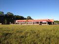
The ACE building
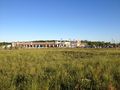
WalMart
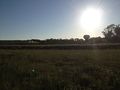
Gingerbread House is there somewhere
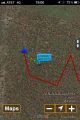
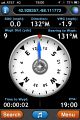
Stupid GPS doesn't track fast
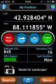
GPS reading
GPS reading
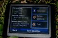
GPS

Grin
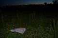
Garbage Gatherer Get!


Achievements
RocketMac earned the Land geohash achievement
|
Hezekiah earned the Land geohash achievement
|