Difference between revisions of "2008-05-24 38 -87"
From Geohashing
(→People) |
m |
||
| (One intermediate revision by one other user not shown) | |||
| Line 12: | Line 12: | ||
[[User:Quicksilver|Quicksilver]], [[User:calt|calt]], Zach, and Brandon reached the geohash around 4:15pm with typoed piece of paper in hand, but there was no sign of other geohashers, past or present. | [[User:Quicksilver|Quicksilver]], [[User:calt|calt]], Zach, and Brandon reached the geohash around 4:15pm with typoed piece of paper in hand, but there was no sign of other geohashers, past or present. | ||
| + | ==Photos== | ||
<gallery caption="Click for larger photo." widths="250px" heights="200px" perrow="2"> | <gallery caption="Click for larger photo." widths="250px" heights="200px" perrow="2"> | ||
Image:Standing-in-field.jpg | Image:Standing-in-field.jpg | ||
| Line 20: | Line 21: | ||
[[Category:Expeditions with photos]] | [[Category:Expeditions with photos]] | ||
[[Category:Coordinates reached]] | [[Category:Coordinates reached]] | ||
| + | {{location|US|IN|VA}} | ||
Latest revision as of 18:05, 23 December 2020
| Sat 24 May 2008 in 38,-87: 38.1266480, -87.5475331 geohashing.info google osm bing/os kml crox |
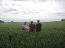
The Vincennes geohash for Saturday was located in a wheat field off of Baseline Road and Highway 41. Some adventuring was required to reach the field, over drainage ditches and poison ivy encrusted embankments.
People
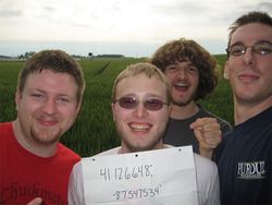
Quicksilver, calt, Zach, and Brandon reached the geohash around 4:15pm with typoed piece of paper in hand, but there was no sign of other geohashers, past or present.
Photos
- Click for larger photo.

