Difference between revisions of "2012-05-05 38 -94"
imported>QuantumCop (Created page with "{{subst:Expedition |lat = latitude of graticule |lon = longitude of graticule |date = date of expedition, in YYYY-MM-DD format }}") |
m (per Renaming Proposal) |
||
| (5 intermediate revisions by 4 users not shown) | |||
| Line 1: | Line 1: | ||
| − | |||
| − | |||
| − | |||
| − | |||
| − | |||
| − | |||
| − | |||
| − | |||
| − | |||
| − | |||
{{meetup graticule | {{meetup graticule | ||
| − | | lat= | + | | lat=38 |
| − | | lon= | + | | lon=-94 |
| − | | date= | + | | date=2012-05-05 |
}} | }} | ||
| − | |||
__NOTOC__ | __NOTOC__ | ||
== Location == | == Location == | ||
| − | + | ||
| + | In a large open field near a big building of some sort in Olathe, Kansas | ||
== Participants == | == Participants == | ||
| − | + | *[[User:QuantumCop|QuantumCop]] | |
| − | + | *Brett | |
== Plans == | == Plans == | ||
| − | + | As this was a Saturday geohash, we planned to meet at QuantumCop's apartment and leave from there at around 2:45 PM. It would be about a 45 minute drive, and that would give us some time to have a look around the site and actually find the geohash. | |
== Expedition == | == Expedition == | ||
| − | + | We left from Lawrence as planned around 2:45 PM or so, and headed East along KS 10 to get to Olathe. When we arrived at the building, which had a large, convenient parking lot, we found that it was some sort of John Deere building. There were some examples of large farm equipment standing outside the building, so we got some pictures of them. | |
| + | |||
| + | Between the building and the geohash point was a large artifical pond. We took a leisurely stroll around the pond on some nice walking paths, and headed towards the field. The field was filled with tall grass and not much else. We waded out through the grass towards the point, danced around a bit with the GPS to get as close as possible, and snapped some pictures of our proof and stupid grins. We waited around just a bit to see if any other geohashers might show up, but none did. I'm beginning to think that these graticules are a bit dead. | ||
| + | |||
| + | Before heading home, we noticed a pice of old, broken down farm equipment sitting at one edge of the field. We decided to check it out just a bit before heading home again. | ||
| − | |||
| − | |||
== Photos == | == Photos == | ||
| − | |||
| − | |||
| − | |||
<gallery perrow="5"> | <gallery perrow="5"> | ||
| + | Image:2012-05-05_38_-94_equipment.JPG | Some farming equipment | ||
| + | Image:2012-05-05_38_-94_sign.jpg | A sign talking about open space | ||
| + | Image:2012-05-05_38_-94_lake.jpg | An artificial lake | ||
| + | Image:2012-05-05_38_-94_hash.jpg | The hashpoint | ||
| + | Image:2012-05-05_38_-94_proof.jpg |The proof | ||
| + | Image:2012-05-05_38_-94_mygrin.jpg | My stupid grin | ||
| + | Image:2012-05-05_38_-94_brett.jpg | Brett's stupid grin | ||
| + | Image:2012-05-05_38_-94_old.jpg | Some very old farm equipment | ||
</gallery> | </gallery> | ||
== Achievements == | == Achievements == | ||
{{#vardefine:ribbonwidth|800px}} | {{#vardefine:ribbonwidth|800px}} | ||
| − | + | {{Graticule unlocked | |
| + | | latitude = 38 | ||
| + | | longitude = -94 | ||
| + | | date = 2012-05-05 | ||
| + | | name = [[User:QuantumCop|QuantumCop]] & Brett | ||
| + | }} | ||
| + | {{land geohash | ||
| + | | latitude = 38 | ||
| + | | longitude = -94 | ||
| + | | date = 2012-05-05 | ||
| + | | name = Brett | ||
| − | + | }} | |
| − | |||
| − | |||
| − | |||
| − | |||
| − | |||
| − | |||
| − | |||
[[Category:Expeditions]] | [[Category:Expeditions]] | ||
| − | |||
[[Category:Expeditions with photos]] | [[Category:Expeditions with photos]] | ||
| − | |||
| − | |||
| − | |||
| − | |||
| − | |||
[[Category:Coordinates reached]] | [[Category:Coordinates reached]] | ||
| − | + | {{location|US|KS|JO}} | |
| − | |||
| − | |||
| − | |||
| − | |||
| − | |||
| − | |||
| − | |||
| − | |||
| − | |||
Latest revision as of 05:39, 20 March 2024
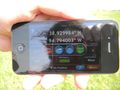
| Sat 5 May 2012 in 38,-94: 38.9300117, -94.7941584 geohashing.info google osm bing/os kml crox |
Location
In a large open field near a big building of some sort in Olathe, Kansas
Participants
- QuantumCop
- Brett
Plans
As this was a Saturday geohash, we planned to meet at QuantumCop's apartment and leave from there at around 2:45 PM. It would be about a 45 minute drive, and that would give us some time to have a look around the site and actually find the geohash.
Expedition
We left from Lawrence as planned around 2:45 PM or so, and headed East along KS 10 to get to Olathe. When we arrived at the building, which had a large, convenient parking lot, we found that it was some sort of John Deere building. There were some examples of large farm equipment standing outside the building, so we got some pictures of them.
Between the building and the geohash point was a large artifical pond. We took a leisurely stroll around the pond on some nice walking paths, and headed towards the field. The field was filled with tall grass and not much else. We waded out through the grass towards the point, danced around a bit with the GPS to get as close as possible, and snapped some pictures of our proof and stupid grins. We waited around just a bit to see if any other geohashers might show up, but none did. I'm beginning to think that these graticules are a bit dead.
Before heading home, we noticed a pice of old, broken down farm equipment sitting at one edge of the field. We decided to check it out just a bit before heading home again.
Photos
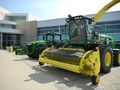
Some farming equipment
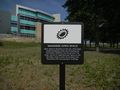
A sign talking about open space
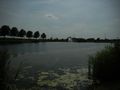
An artificial lake
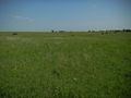
The hashpoint
The proof
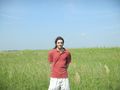
My stupid grin
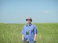
Brett's stupid grin
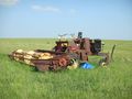
Some very old farm equipment


Achievements
QuantumCop & Brett earned the Graticule Unlocked Achievement
|
Brett earned the Land geohash achievement
|