Difference between revisions of "2012-06-29 47 7"
From Geohashing
imported>Crox (last minute plan) |
imported>FippeBot m (Location) |
||
| (2 intermediate revisions by 2 users not shown) | |||
| Line 1: | Line 1: | ||
| − | |||
| − | |||
| − | |||
| − | |||
{{meetup graticule | {{meetup graticule | ||
| lat=47 | | lat=47 | ||
| Line 9: | Line 5: | ||
}} | }} | ||
| − | |||
__NOTOC__ | __NOTOC__ | ||
== Location == | == Location == | ||
| − | + | Near [[wikipedia:Wangen an der Aare|Wangen an der Aare]] | |
== Participants == | == Participants == | ||
| − | |||
| − | |||
[[user:Crox|Crox]] | [[user:Crox|Crox]] | ||
| − | |||
| − | |||
| − | |||
| − | |||
== Expedition == | == Expedition == | ||
| − | + | Drove there from Solothurn. Parked the car next to a small shooting range (~ 40 m from the hash in a straight line). Right next to it there was what looked like a way leading straight to the hash. Unfortunately the path ended way too fast and instead had to climb steep slopes and wade through a waist high forest of [[wikipedia:Stinging_nettle|stinging nettle]]... Eventually the hash was reached, and a somewhat more convenient way out was found. Now writing the report on the train back home. | |
| − | |||
| − | |||
| − | |||
| − | |||
| − | |||
| − | |||
| − | |||
| − | |||
| − | |||
| − | |||
| − | |||
| − | |||
| − | |||
| − | |||
| + | == Photos == | ||
| + | {{#vardefine:gaLines|3}} | ||
| + | {{#vardefine:gaWidth|250}} | ||
| + | {{#vardefine:gaHeight|230}} | ||
| + | {{Gallery2| | ||
| + | {{GalleryItem | File:2012-06-29_47_7_01_urtica_29062012050.jpg | [[wikipedia:Stinging_nettle|stinging nettle]] }} | ||
| + | {{GalleryItem | File:2012-06-29_47_7_02_stumps_29062012052.jpg | way to the hash }} | ||
| + | {{GalleryItem | File:2012-06-29_47_7_03_gps_4497.png | reached! }} | ||
| + | {{GalleryItem | File:2012-06-29_47_7_04_hasher_29062012054.jpg | hasher... }} | ||
| + | {{GalleryItem | File:2012-06-29_47_7_05_hash_29062012055.jpg | ... at the hash }} | ||
| + | }} | ||
| − | |||
| − | |||
| − | |||
| − | |||
| − | |||
| − | |||
[[Category:Expeditions]] | [[Category:Expeditions]] | ||
| − | |||
| − | |||
| − | |||
| − | |||
[[Category:Expeditions with photos]] | [[Category:Expeditions with photos]] | ||
| − | |||
| − | |||
| − | |||
| − | |||
| − | |||
[[Category:Coordinates reached]] | [[Category:Coordinates reached]] | ||
| − | + | {{location|CH|BE}} | |
| − | |||
| − | |||
| − | |||
| − | |||
| − | |||
| − | |||
| − | |||
| − | |||
| − | |||
Latest revision as of 04:47, 13 August 2019
| Fri 29 Jun 2012 in 47,7: 47.2226083, 7.6583566 geohashing.info google osm bing/os kml crox |
Location
Near Wangen an der Aare
Participants
Expedition
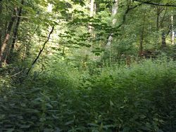
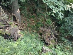
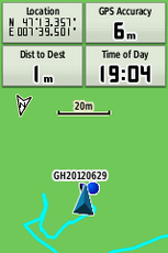
Drove there from Solothurn. Parked the car next to a small shooting range (~ 40 m from the hash in a straight line). Right next to it there was what looked like a way leading straight to the hash. Unfortunately the path ended way too fast and instead had to climb steep slopes and wade through a waist high forest of stinging nettle... Eventually the hash was reached, and a somewhat more convenient way out was found. Now writing the report on the train back home.
Photos
|


