Difference between revisions of "2012-07-04 45 -111"
From Geohashing
imported>Davidfg4 m (fix user link) |
m (per Renaming Proposal) |
||
| (6 intermediate revisions by 3 users not shown) | |||
| Line 17: | Line 17: | ||
__NOTOC__ | __NOTOC__ | ||
== Location == | == Location == | ||
| − | + | On the side of the road, just a few miles south of Bozeman, Montana. | |
== Participants == | == Participants == | ||
| Line 26: | Line 26: | ||
== Expedition == | == Expedition == | ||
| − | Left work at 3:30, and headed to the location. Got passed by a firetruck on they way, but other than that it was fairly uneventful. There was a convenient place to park on the side of the road just 200 ft away, and it was an easy walk over to the geohash. The location was in the ditch on the side of the road. Took some pictures and left a biodegradable sign, then retreated from the heat. | + | Left work at 3:30 pm, and headed to the location. Got passed by a firetruck on they way, but other than that it was fairly uneventful. There was a convenient place to park on the side of the road just 200 ft away, and it was an easy walk over to the geohash. The location was in the ditch on the side of the road. Took some pictures and left a biodegradable sign, then retreated from the heat. |
== Tracklog == | == Tracklog == | ||
| Line 36: | Line 36: | ||
--> | --> | ||
<gallery perrow="5"> | <gallery perrow="5"> | ||
| + | Image:2012-07-04_45_-111_davidfg4_stupid_grin.jpg|Stupid Grin | ||
| + | Image:2012-07-04_45_-111_davidfg4_gps.jpg|GPS proof | ||
</gallery> | </gallery> | ||
| Line 45: | Line 47: | ||
| date = 2012-07-04 | | date = 2012-07-04 | ||
}} | }} | ||
| − | {{ | + | {{Graticule unlocked |
| latitude = 45 | | latitude = 45 | ||
| longitude = -111 | | longitude = -111 | ||
| Line 54: | Line 56: | ||
<!-- Add any achievement ribbons you earned below, or remove this section --> | <!-- Add any achievement ribbons you earned below, or remove this section --> | ||
| − | |||
| − | |||
| − | |||
| − | |||
| − | |||
| − | |||
| − | |||
| − | |||
| − | |||
| − | |||
| − | |||
[[Category:Expeditions]] | [[Category:Expeditions]] | ||
| − | |||
[[Category:Expeditions with photos]] | [[Category:Expeditions with photos]] | ||
| − | |||
| − | |||
| − | |||
| − | |||
| − | |||
[[Category:Coordinates reached]] | [[Category:Coordinates reached]] | ||
| − | + | {{location|US|MT|GL}} | |
| − | |||
| − | |||
| − | |||
| − | |||
| − | |||
| − | |||
| − | |||
| − | |||
| − | |||
Latest revision as of 05:35, 20 March 2024
| Wed 4 Jul 2012 in 45,-111: 45.5908082, -111.0739284 geohashing.info google osm bing/os kml crox |
Location
On the side of the road, just a few miles south of Bozeman, Montana.
Participants
Plans
I have been watching geohashes for a while, and was waiting for an easy one. This one seemed just right. It would only be a ~15 mile detour on the way home from work.
Expedition
Left work at 3:30 pm, and headed to the location. Got passed by a firetruck on they way, but other than that it was fairly uneventful. There was a convenient place to park on the side of the road just 200 ft away, and it was an easy walk over to the geohash. The location was in the ditch on the side of the road. Took some pictures and left a biodegradable sign, then retreated from the heat.
Tracklog
Photos

Stupid Grin
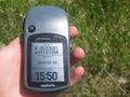
GPS proof


Achievements
davidfg4 earned the Land geohash achievement
|
davidfg4 earned the Graticule Unlocked Achievement
|