Difference between revisions of "2012-07-15 52 5"
imported>Eupeodes (→Achievements) |
imported>FippeBot m (Location) |
||
| (9 intermediate revisions by 3 users not shown) | |||
| Line 1: | Line 1: | ||
| − | |||
| − | |||
| − | |||
| − | |||
| − | |||
| − | |||
| − | |||
| − | |||
| − | |||
| − | |||
{{meetup graticule | {{meetup graticule | ||
| lat=52 | | lat=52 | ||
| Line 15: | Line 5: | ||
}} | }} | ||
| − | |||
__NOTOC__ | __NOTOC__ | ||
== Location == | == Location == | ||
| − | |||
In Apeldoorn on the bank of the Apeldoorn Kanaal | In Apeldoorn on the bank of the Apeldoorn Kanaal | ||
== Participants == | == Participants == | ||
| − | |||
| − | |||
[[User:Eupeodes|Eupeodes]] | [[User:Eupeodes|Eupeodes]] | ||
| Line 29: | Line 15: | ||
== Plans == | == Plans == | ||
| − | |||
[[User:Shevek|Shevek]] planned to go hitchhiking and be there at 3pm, [[User:Eupeodes|Eupeodes]] decided to go by bike and arrive at the same moment. It worked out differently. | [[User:Shevek|Shevek]] planned to go hitchhiking and be there at 3pm, [[User:Eupeodes|Eupeodes]] decided to go by bike and arrive at the same moment. It worked out differently. | ||
== Expedition == | == Expedition == | ||
| − | |||
===Eupeodes=== | ===Eupeodes=== | ||
Intended to leave at around 1pm so I would be there at 3pm and be back home before dinner. In the end I left at around 3:45 by recumbent bike. The ride started nice, bit up and down. Of course my speed dropped around Hoenderloo, it always does. After this I had some longe stretches down, speeds exceeded 40 km/h, it was chilly. Arrived at the hashpoint at 5:36pm. Took some pictures and set of to get back home. Since I was aiming for tron and I don't like driving the same way back anyways I took a different route. After some time it started to rain so I took shelter under a tree. Waited until the worst part passed and just at that moment the tree started to leak so I continued my way. When I was in Arnhem it was already around 8pm and I hadn't had diner yet, so got some pasta at Julia's at the central station. Now I could continue my way home and I arrived home with a bit over 100 km driven (40 to the hash, 60 the way back). | Intended to leave at around 1pm so I would be there at 3pm and be back home before dinner. In the end I left at around 3:45 by recumbent bike. The ride started nice, bit up and down. Of course my speed dropped around Hoenderloo, it always does. After this I had some longe stretches down, speeds exceeded 40 km/h, it was chilly. Arrived at the hashpoint at 5:36pm. Took some pictures and set of to get back home. Since I was aiming for tron and I don't like driving the same way back anyways I took a different route. After some time it started to rain so I took shelter under a tree. Waited until the worst part passed and just at that moment the tree started to leak so I continued my way. When I was in Arnhem it was already around 8pm and I hadn't had diner yet, so got some pasta at Julia's at the central station. Now I could continue my way home and I arrived home with a bit over 100 km driven (40 to the hash, 60 the way back). | ||
| Line 40: | Line 24: | ||
===Shevek=== | ===Shevek=== | ||
| + | My plans, including the change, are documented [[2012-07-15 53 5|here]], as is the first part of my expedition. It continues [[2012-07-15 52 4|here]]. After that, my friend dropped my off at the highway to Utrecht. I planned to do Utrecht, Amersfoort, Apeldoorn. However, I got a ride to Utrecht, then to Nieuwegein. I mistakenly got out too late. I turned around there, to get back on the road, but had to wait a long time. Eventually I was picked up and driven to the place where I should have gotten out in the first place. I was standing just behind the "start of highway" sign, at the place where the emergency lane started. It seemed to be the safest place to stand. However, a police car stopped, and the officer instructed me to stand before the sign instead, in a much more dangerous place (not for me, but for the stopping cars). Whatever you say, officer... Luckily, it didn't take long before I got a ride to Utrecht again, a bit closer to the highway to Amersfoort this time. And there was no accident when I got into the car. But not many cars for Amersfoort passed in the new spot, so eventually I accepted a ride to Ede, and changed the plan to go from there to Arnhem, Apeldoorn. Not a large detour anyway. | ||
| + | |||
| + | Ede-Wageningen seems like a perfect place for hitch-hiking: traffic from two towns goes onto the highway there, and the highway only goes to Arnhem, so any car that stops is good. So far the theoretical part. It took more than two hours before a car stopped. That car contained a woman and a dog. The dog seemed uneasy. The woman said it was a "wild pittbull", and she wasn't sure if it was safe. She recommended me not to trust it (in other words, not to get into the car). Well, it was her dog, so I suppose she would know. Then why did she stop in the first place? Ah well. | ||
| + | |||
| + | It was getting dark, and I was beginning to worry that I might not make it back home. Luckily, I had had enough bad luck, it seemed, because then something good happened: a car stopped, with three people who lived very close to Emmeloord, where I grew up. And they were happy to take me there. I was happy to have a roof for the night, so I accepted the offer. When I told them about my expedition, and asked if they could make a detour in Apeldoorn, they liked the idea. So they joined me to the hash. | ||
| + | |||
| + | Getting there was not the problem. Getting my gps to work was. Maybe it was the trees, maybe my gps is just broken. Anyway, it was sometimes sort of steady at a few meters distance from the hash, and then it jumped to 70 or even 200 meters without us even moving. It was quite easy to be at the hash point within the accuracy of the gps device at that moment. The screenshot was taken at a sort of short distance. | ||
| + | |||
| + | My drivers wanted to be on the picture with me. I was told I had to stand next to the girl. She was a beautiful girl, so I happily agreed. | ||
| + | |||
| + | They brought me to my father's house, where I arrived after 23:00. It was dark by then, and I was happy I didn't have to hitch-hike all the way to Groningen. I'll do that tomorrow. I'll take a short detour and go over [[2012-07-16 52 6|Hoogezand]]. | ||
== Tracklog == | == Tracklog == | ||
| Line 46: | Line 41: | ||
== Photos == | == Photos == | ||
| − | |||
| − | |||
| − | |||
===Eupeodes=== | ===Eupeodes=== | ||
<gallery perrow="5"> | <gallery perrow="5"> | ||
| Line 60: | Line 52: | ||
Image:2012-07-15_52_5_Sun1.JPG | Sun going down | Image:2012-07-15_52_5_Sun1.JPG | Sun going down | ||
Image:2012-07-15_52_5_Sun2.JPG | Sun going down | Image:2012-07-15_52_5_Sun2.JPG | Sun going down | ||
| + | </gallery> | ||
| + | ===Shevek=== | ||
| + | <gallery perrow="5"> | ||
| + | Image:2012-07-15 52 5 hitchhiking.jpg|I really was hitch-hiking. And I really didn't have a sign. | ||
| + | Image:2012-07-15 52 5 group.jpg|All four of us. Note how the girl is standing next to me. ;-) | ||
| + | Image:2012-07-15 52 5 diabolo henk.jpg|The driver, playing with my diabolo. | ||
| + | Image:2012-07-15 52 5 diabolo4.jpg|Me, playing with my diabolo. | ||
| + | Image:2012-07-15 52 5 screenshot.png|The gps also agrees we are sort of there. | ||
</gallery> | </gallery> | ||
| Line 69: | Line 69: | ||
| longitude = 5 | | longitude = 5 | ||
| date = 2012-07-15 | | date = 2012-07-15 | ||
| − | | comboname = Earliest consecutive bicycle tron land geohash | + | | comboname = [[Earliest_geohasher_achievement|Earliest]] [[Consecutive_geohash_achievement|consecutive]] [[Bicycle_geohash_achievement|bicycle]] [[Tron_achievement|tron]] [[Land_geohash_achievement|land]] geohash |
| − | | action = biking to the hash, reaching it before Shevek and not crossing his own | + | | action = biking to the hash, reaching it before [[User:Shevek|Shevek]] and not crossing his [https://maps.google.nl/maps?q=http:%2F%2Fgeohashing.eupeodes.nl%2Ftracks%2F20120715.kml&hl=nl&ll=52.078998,5.937716&spn=0.508926,0.883026&sll=51.977816,5.744769&sspn=0.255039,0.441513&t=w&z=10 own tracks] |
| name = [[User:Eupeodes|Eupeodes]] | | name = [[User:Eupeodes|Eupeodes]] | ||
| − | |||
| icon1 = Earliest.jpg | | icon1 = Earliest.jpg | ||
| icon2 = consecutivegeohash.jpg | | icon2 = consecutivegeohash.jpg | ||
| Line 85: | Line 84: | ||
| image = 2012-07-15_52_5_Me_and_my_bike.JPG | | image = 2012-07-15_52_5_Me_and_my_bike.JPG | ||
}} | }} | ||
| − | + | {{land geohash | |
| − | {{ | ||
| latitude = 52 | | latitude = 52 | ||
| longitude = 5 | | longitude = 5 | ||
| date = 2012-07-15 | | date = 2012-07-15 | ||
| − | | name = [[User: | + | | name = [[User:Shevek|Shevek]] |
| − | |||
}} | }} | ||
| − | {{ | + | {{Thumbs Up |
| latitude = 52 | | latitude = 52 | ||
| longitude = 5 | | longitude = 5 | ||
| date = 2012-07-15 | | date = 2012-07-15 | ||
| − | | name = [[User: | + | | name = [[User:Shevek|Shevek]] |
| − | | | + | | image = 2012-07-15 52 5 hitchhiking.jpg |
| − | |||
}} | }} | ||
| − | {{ | + | {{Circus_geohash |
| latitude = 52 | | latitude = 52 | ||
| longitude = 5 | | longitude = 5 | ||
| date = 2012-07-15 | | date = 2012-07-15 | ||
| − | | name = [[User: | + | | name = [[User:Shevek|Shevek]] |
| − | + | | image = 2012-07-15 52 5 diabolo4.jpg | |
| − | | image = 2012-07- | + | | performance = throwing a diabolo around |
}} | }} | ||
| − | {{ | + | {{drag-along |
| latitude = 52 | | latitude = 52 | ||
| longitude = 5 | | longitude = 5 | ||
| date = 2012-07-15 | | date = 2012-07-15 | ||
| − | | name = [[User: | + | | name = [[User:Shevek|Shevek]] |
| − | | | + | | image = 2012-07-15 52 5 diabolo henk.jpg |
| − | | | + | | partner = three hitchees |
}} | }} | ||
| − | {{ | + | {{police geohash |
| latitude = 52 | | latitude = 52 | ||
| longitude = 5 | | longitude = 5 | ||
| date = 2012-07-15 | | date = 2012-07-15 | ||
| − | | name = [[User: | + | | name = [[User:Shevek|Shevek]] |
| − | }} | + | | image = 2012-07-15 52 5 hitchhiking.jpg |
| + | | encounter = being told by a police officer to stand in a more dangerous location | ||
| + | | anim = true | ||
| + | }} | ||
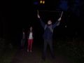
| + | {{Multihash2 | count = 3 | date = 2012-07-15 | name = [[User:Shevek|Shevek]] | image = 2012-07-15 52 5 group.jpg }} | ||
[[Category:Expeditions]] | [[Category:Expeditions]] | ||
| Line 128: | Line 128: | ||
[[Category:Coordinates reached]] | [[Category:Coordinates reached]] | ||
[[Category:Eupeodes]] | [[Category:Eupeodes]] | ||
| + | [[Category:Shevek]] | ||
| + | {{location|NL|GE}} | ||
Latest revision as of 05:03, 13 August 2019
| Sun 15 Jul 2012 in 52,5: 52.1840800, 5.9890418 geohashing.info google osm bing/os kml crox |
Location
In Apeldoorn on the bank of the Apeldoorn Kanaal
Participants
Plans
Shevek planned to go hitchhiking and be there at 3pm, Eupeodes decided to go by bike and arrive at the same moment. It worked out differently.
Expedition
Eupeodes
Intended to leave at around 1pm so I would be there at 3pm and be back home before dinner. In the end I left at around 3:45 by recumbent bike. The ride started nice, bit up and down. Of course my speed dropped around Hoenderloo, it always does. After this I had some longe stretches down, speeds exceeded 40 km/h, it was chilly. Arrived at the hashpoint at 5:36pm. Took some pictures and set of to get back home. Since I was aiming for tron and I don't like driving the same way back anyways I took a different route. After some time it started to rain so I took shelter under a tree. Waited until the worst part passed and just at that moment the tree started to leak so I continued my way. When I was in Arnhem it was already around 8pm and I hadn't had diner yet, so got some pasta at Julia's at the central station. Now I could continue my way home and I arrived home with a bit over 100 km driven (40 to the hash, 60 the way back).
It turned out to be some advantage that Eupeodes knew the way quite well. His parents live only about one kilometer from the hash, so he knew the way to the hash. Although Eupeodes cycled/walked almost every part of the Kanaal, the hash appeared to be on one of those rare sections where he had never been yet.
Shevek
My plans, including the change, are documented here, as is the first part of my expedition. It continues here. After that, my friend dropped my off at the highway to Utrecht. I planned to do Utrecht, Amersfoort, Apeldoorn. However, I got a ride to Utrecht, then to Nieuwegein. I mistakenly got out too late. I turned around there, to get back on the road, but had to wait a long time. Eventually I was picked up and driven to the place where I should have gotten out in the first place. I was standing just behind the "start of highway" sign, at the place where the emergency lane started. It seemed to be the safest place to stand. However, a police car stopped, and the officer instructed me to stand before the sign instead, in a much more dangerous place (not for me, but for the stopping cars). Whatever you say, officer... Luckily, it didn't take long before I got a ride to Utrecht again, a bit closer to the highway to Amersfoort this time. And there was no accident when I got into the car. But not many cars for Amersfoort passed in the new spot, so eventually I accepted a ride to Ede, and changed the plan to go from there to Arnhem, Apeldoorn. Not a large detour anyway.
Ede-Wageningen seems like a perfect place for hitch-hiking: traffic from two towns goes onto the highway there, and the highway only goes to Arnhem, so any car that stops is good. So far the theoretical part. It took more than two hours before a car stopped. That car contained a woman and a dog. The dog seemed uneasy. The woman said it was a "wild pittbull", and she wasn't sure if it was safe. She recommended me not to trust it (in other words, not to get into the car). Well, it was her dog, so I suppose she would know. Then why did she stop in the first place? Ah well.
It was getting dark, and I was beginning to worry that I might not make it back home. Luckily, I had had enough bad luck, it seemed, because then something good happened: a car stopped, with three people who lived very close to Emmeloord, where I grew up. And they were happy to take me there. I was happy to have a roof for the night, so I accepted the offer. When I told them about my expedition, and asked if they could make a detour in Apeldoorn, they liked the idea. So they joined me to the hash.
Getting there was not the problem. Getting my gps to work was. Maybe it was the trees, maybe my gps is just broken. Anyway, it was sometimes sort of steady at a few meters distance from the hash, and then it jumped to 70 or even 200 meters without us even moving. It was quite easy to be at the hash point within the accuracy of the gps device at that moment. The screenshot was taken at a sort of short distance.
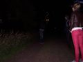
My drivers wanted to be on the picture with me. I was told I had to stand next to the girl. She was a beautiful girl, so I happily agreed.
They brought me to my father's house, where I arrived after 23:00. It was dark by then, and I was happy I didn't have to hitch-hike all the way to Groningen. I'll do that tomorrow. I'll take a short detour and go over Hoogezand.
Tracklog
Photos
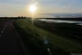
Eupeodes

Picture taken some distance from the hash

Noticed the pictures from the hash with bike were rubish

The rain
In Arnhem
Sun going down
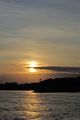
Sun going down


Shevek
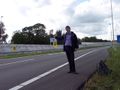
I really was hitch-hiking. And I really didn't have a sign.
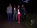
All four of us. Note how the girl is standing next to me. ;-)
The driver, playing with my diabolo.
Me, playing with my diabolo.
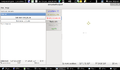
The gps also agrees we are sort of there.


Achievements
Eupeodes earned the Earliest consecutive bicycle tron land geohash Achievement
|
Shevek earned the Land geohash achievement
|
Shevek earned the Thumbs Up Geohash Achievement
|
Shevek earned the Circus Geohash Achievement
|
Shevek earned the Drag-along achievement
|
Shevek earned the Police Geohash Achievement
|
Shevek earned the Multihash Achievement
|
- Meetup on 2012-07-15
- Meetup in 52 5
- Combo achievement
- Earliest geohash achievement
- Consecutive geohash achievement
- Bicycle geohash achievement
- Tron achievement
- Land geohash achievement
- Thumbs up geohash achievement
- Circus geohash achievement
- Drag-along achievement
- Police geohash achievement
- Multihash achievement
- Expeditions
- Expeditions with photos
- Coordinates reached
- Eupeodes
- Shevek
- Meetup in Gelderland