Difference between revisions of "2012-07-22 32 -116"
From Geohashing
imported>LucasBrown (→Achievements) |
imported>FippeBot m (Location) |
||
| (3 intermediate revisions by 2 users not shown) | |||
| Line 1: | Line 1: | ||
| − | |||
| − | |||
| − | |||
| − | |||
| − | |||
| − | |||
| − | |||
| − | |||
| − | |||
| − | |||
{{meetup graticule | {{meetup graticule | ||
| lat=32 | | lat=32 | ||
| Line 15: | Line 5: | ||
}} | }} | ||
| − | |||
__NOTOC__ | __NOTOC__ | ||
== Location == | == Location == | ||
| − | + | On a hillside south of Campo Road | |
== Participants == | == Participants == | ||
| − | + | [[User:LucasBrown|LucasBrown]] | |
| − | |||
== Expedition == | == Expedition == | ||
| − | + | The closest vehicular approach was about 600 meters north of the hashpoint; proceeding south by foot, the hashers encountered a dense riparian zone. After about 200 meters of this, the plants became too thick to penetrate and the expedition was called off. | |
== Photos == | == Photos == | ||
| − | |||
| − | |||
| − | |||
<gallery perrow="5"> | <gallery perrow="5"> | ||
| Line 38: | Line 23: | ||
</gallery> | </gallery> | ||
| − | |||
| − | |||
| − | |||
| − | |||
| − | |||
[[Category:Expeditions]] | [[Category:Expeditions]] | ||
[[Category:Expeditions with photos]] | [[Category:Expeditions with photos]] | ||
| − | |||
[[Category:Coordinates not reached]] | [[Category:Coordinates not reached]] | ||
[[Category:Not reached - Mother Nature]] | [[Category:Not reached - Mother Nature]] | ||
| + | {{location|US|CA|SD}} | ||
Latest revision as of 05:10, 13 August 2019
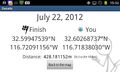
| Sun 22 Jul 2012 in 32,-116: 32.5994754, -116.7209116 geohashing.info google osm bing/os kml crox |
Location
On a hillside south of Campo Road
Participants
Expedition
The closest vehicular approach was about 600 meters north of the hashpoint; proceeding south by foot, the hashers encountered a dense riparian zone. After about 200 meters of this, the plants became too thick to penetrate and the expedition was called off.
Photos
Closest approach
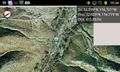
Closest approach

