Difference between revisions of "2012-07-30 47 8"
imported>Calamus (Created page with "{{subst:Expedition|lat=47|lon=8|date=2012-07-30}}") |
imported>FippeBot m (Location) |
||
| (7 intermediate revisions by one other user not shown) | |||
| Line 1: | Line 1: | ||
| + | [[Image:{{{image|2012-07-30 47 8 almost a path.jpg}}}|thumb|left]] | ||
| − | |||
| − | |||
| − | |||
| − | |||
| − | |||
| − | |||
| − | |||
| − | |||
| − | |||
{{meetup graticule | {{meetup graticule | ||
| lat=47 | | lat=47 | ||
| Line 15: | Line 7: | ||
}} | }} | ||
| − | |||
__NOTOC__ | __NOTOC__ | ||
== Location == | == Location == | ||
| − | + | Sihlwald, near Hausen a.A. | |
== Participants == | == Participants == | ||
| − | + | [[User:Calamus|Calamus]] | |
| − | |||
== Plans == | == Plans == | ||
| − | + | S4 to Langnau, pass hashpoint, bus from Hausen, try for a [[Tron achievement]] | |
== Expedition == | == Expedition == | ||
| − | + | If anyone was ever going to ask Calamus about his three most unfavorable anti-talents during a job interview again, he knew what he was going to answer: estimating walking distances, agreeing with the Java design goals and consulting height maps. | |
| + | |||
| + | Something about the position of the day's hashpoint had led him to consider a tron attempt a pretty good idea. His plan had been to leave Zurich to the south, using the train to Langnau. Next he was going to take a path through the forest, which he had carefully drawn out on a sheet of paper, that was going to lead him quite close to the hashpoint. Then he was going to find another path leading to Hausen, from where he was going back to Zurich from the west. | ||
| + | |||
| + | So far, this had worked wonderfully. Well, he had managed to take a wrong turn once and, unable to turn back, had to ad-lib a detour. Also, he wasn't very sure whether he had taken the very last turn correctly. But whatever, if he had missed the junction, he was just going to reach the hashpoint from the other side. After all, Sihlwald forest was known to be rather flat. | ||
| + | |||
| + | Calamus hadn't thought of the fact that the Swiss word for 'flat' didn't necessarily imply passable terrain, but was just short for 'too boring to mountaineer on'. And so he found himself next to a boulder, which had a plaquette embedded in it proclaiming that this was the highest point of Albis Ridge, and a precipice where his GPS located the point, less then hundred metres away horizontally, and only slightly more vertically. There was, in fact, a passage. But there was only this one. Using it meant he was not going to be able to go on to Hausen, which wouldn't have been more than a comfortable walk away, but instead had to walk all the way down again. He didn't have much of a choice. | ||
| + | |||
| + | Down in the abyss, which still was pretty high up, Calamus carefully tried not only not to cross his way, but also not to fall to death. After some time and slow movement, he had reached the point. Now for returning. | ||
| + | |||
| + | There was no way Calamus could squeeze past the trace he had left, as the passage was far too narrow, so he went on to the valley until he reached Sihlbrugg. Sihlbrugg had once been important enough to be the terminal station of the only railway in the region, but the railway now extended all the way to Zurich and all importance had been long forgotten; as a woman on the station told Calamus, the train was even going to cease stopping there from next winter, as it didn't pay off for the handful of inhabitants. | ||
| + | |||
| + | Calamus took the train to Zug. This was, of course, a detour, but he had already used the same track on his way here. From Zug, he took the train back to Zurich on another track further in the west. This enabled him to enter Zurich from another side and subsequently reach his home without ever visiting a point twice. | ||
== Tracklog == | == Tracklog == | ||
| − | + | [http://www.everytrail.com/view_trip.php?trip_id=1695925 On EveryTrail] | |
== Photos == | == Photos == | ||
| − | |||
| − | |||
| − | |||
<gallery perrow="5"> | <gallery perrow="5"> | ||
| + | Image:2012-07-30 47 8 plan.jpg | Calamus's evil plan | ||
| + | Image:2012-07-30 47 8 bottom.jpg | At the bottom... | ||
| + | Image:2012-07-30 47 8 top total.jpg | ...and up at the top | ||
| + | Image:2012-07-30 47 8 top detail.jpg | "Bürglenstutz, 915 metres, summit of Albis Ridge" | ||
| + | Image:2012-07-30 47 8 down.jpg | Just down there – mind the drop | ||
| + | Image:2012-07-30 47 8 almost a path.jpg | There's almost a path! | ||
| + | Image:2012-07-30 47 8 hash.jpg | Here we are | ||
</gallery> | </gallery> | ||
== Achievements == | == Achievements == | ||
{{#vardefine:ribbonwidth|800px}} | {{#vardefine:ribbonwidth|800px}} | ||
| − | + | {{Land geohash|latitude=47|longitude=8|date=2012-07-30|name=[[User:Calamus|Calamus]]}} | |
| − | + | {{Public transport geohash|latitude=47|longitude=8|date=2012-07-30|name=[[User:Calamus|Calamus]]}} | |
| − | + | {{Tron|latitude=47|longitude=8|date=2012-07-30|name=[[User:Calamus|Calamus]]|possessive=his|tracklog=http://www.everytrail.com/view_trip.php?trip_id=1695925}} | |
| − | + | {{Consecutive geohash|latitude=47|longitude=8|date=2012-07-29|name=[[User:Calamus|Calamus]]|count=2}} | |
| − | |||
| − | [[ | ||
| − | |||
| − | |||
| − | |||
| − | [[ | ||
| − | |||
| − | |||
[[Category:Expeditions]] | [[Category:Expeditions]] | ||
| − | |||
[[Category:Expeditions with photos]] | [[Category:Expeditions with photos]] | ||
| − | + | ||
| − | |||
| − | |||
| − | |||
| − | |||
[[Category:Coordinates reached]] | [[Category:Coordinates reached]] | ||
| − | + | {{location|CH|ZH}} | |
| − | |||
| − | |||
| − | |||
| − | |||
| − | |||
| − | |||
| − | |||
| − | |||
| − | |||
| − | |||
| − | |||
| − | |||
| − | |||
| − | |||
| − | |||
| − | |||
| − | |||
Latest revision as of 05:18, 13 August 2019

| Mon 30 Jul 2012 in 47,8: 47.2517686, 8.5457375 geohashing.info google osm bing/os kml crox |
Location
Sihlwald, near Hausen a.A.
Participants
Plans
S4 to Langnau, pass hashpoint, bus from Hausen, try for a Tron achievement
Expedition
If anyone was ever going to ask Calamus about his three most unfavorable anti-talents during a job interview again, he knew what he was going to answer: estimating walking distances, agreeing with the Java design goals and consulting height maps.
Something about the position of the day's hashpoint had led him to consider a tron attempt a pretty good idea. His plan had been to leave Zurich to the south, using the train to Langnau. Next he was going to take a path through the forest, which he had carefully drawn out on a sheet of paper, that was going to lead him quite close to the hashpoint. Then he was going to find another path leading to Hausen, from where he was going back to Zurich from the west.
So far, this had worked wonderfully. Well, he had managed to take a wrong turn once and, unable to turn back, had to ad-lib a detour. Also, he wasn't very sure whether he had taken the very last turn correctly. But whatever, if he had missed the junction, he was just going to reach the hashpoint from the other side. After all, Sihlwald forest was known to be rather flat.
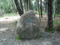
Calamus hadn't thought of the fact that the Swiss word for 'flat' didn't necessarily imply passable terrain, but was just short for 'too boring to mountaineer on'. And so he found himself next to a boulder, which had a plaquette embedded in it proclaiming that this was the highest point of Albis Ridge, and a precipice where his GPS located the point, less then hundred metres away horizontally, and only slightly more vertically. There was, in fact, a passage. But there was only this one. Using it meant he was not going to be able to go on to Hausen, which wouldn't have been more than a comfortable walk away, but instead had to walk all the way down again. He didn't have much of a choice.
Down in the abyss, which still was pretty high up, Calamus carefully tried not only not to cross his way, but also not to fall to death. After some time and slow movement, he had reached the point. Now for returning.
There was no way Calamus could squeeze past the trace he had left, as the passage was far too narrow, so he went on to the valley until he reached Sihlbrugg. Sihlbrugg had once been important enough to be the terminal station of the only railway in the region, but the railway now extended all the way to Zurich and all importance had been long forgotten; as a woman on the station told Calamus, the train was even going to cease stopping there from next winter, as it didn't pay off for the handful of inhabitants.
Calamus took the train to Zug. This was, of course, a detour, but he had already used the same track on his way here. From Zug, he took the train back to Zurich on another track further in the west. This enabled him to enter Zurich from another side and subsequently reach his home without ever visiting a point twice.
Tracklog
Photos
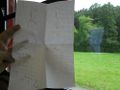
Calamus's evil plan
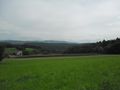
At the bottom...
...and up at the top
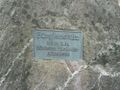
"Bürglenstutz, 915 metres, summit of Albis Ridge"
Just down there – mind the drop
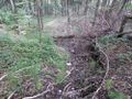
There's almost a path!
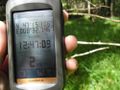
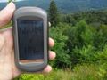
Here we are


Achievements
Calamus earned the Land geohash achievement
|
Calamus earned the Public transport geohash achievement
|
Calamus earned the Tron achievement
|
Calamus earned the Consecutive geohash achievement
|