Difference between revisions of "2012-07-31 -35 149"
imported>1PE (Created page with "{{subst:Expedition |lat = -35 |lon = 149 |date = 2012-07-31}}") |
m (More specific location) |
||
| (10 intermediate revisions by 4 users not shown) | |||
| Line 1: | Line 1: | ||
| + | [[Image:{{{image|2012-07-31_-35_149_gate.JPG}}}|thumb|left]] | ||
| − | |||
| − | |||
| − | |||
| − | |||
| − | |||
| − | |||
| − | |||
| − | |||
| − | |||
{{meetup graticule | {{meetup graticule | ||
| lat=-35 | | lat=-35 | ||
| lon=149 | | lon=149 | ||
| date=2012-07-31 | | date=2012-07-31 | ||
| + | | retro=1 | ||
}} | }} | ||
| Line 18: | Line 11: | ||
__NOTOC__ | __NOTOC__ | ||
== Location == | == Location == | ||
| − | + | The hash was on the south-eastern shore of [http://en.wikipedia.org/wiki/Lake_George_(New_South_Wales) Lake George], north of [http://en.wikipedia.org/wiki/Bungendore_(New_South_Wales Bungendore], about 45km from my office in [http://en.wikipedia.org/wiki/Canbera,_Australian_Capital_Territory Canberra]. It was just north-east of a sand and gravel quarry that gathers materials from the lake edge, and about 1km south of the southern-most windmills of the [http://en.wikipedia.org/wiki/Capital_Wind_Farm Lake George Wind Farm]. | |
== Participants == | == Participants == | ||
| − | + | [[User:1PE|1PE]] | |
| − | |||
== Plans == | == Plans == | ||
| − | + | I planned to go on the day, during my lunch time, but a meeting kept me in the office. | |
| − | == | + | == Retro expedition == |
| − | + | ===1PE=== | |
| + | The expedition became a two-for-one when the site of the next day's geohash [[2012-08-01 -35 149]] was only about 0.5km from the previous day's hash. I went on the second day and explored as close as possible to both hashes. | ||
| − | + | I discovered, as I expected, that the rural property leading to the sites was off-limits, with a sign to that effect. | |
| − | + | ||
| + | I took a picture of the property sign at the entrance, and left the two geohash 'certificates' on the sign. | ||
| + | |||
| + | I then attempted to gain access to the sand/gravel quarry to get a picture from there. I did not want to approach the quarry office as this would require some explanations that I was not willing to give. So, I followed a truck along the quarry access road until I came to the quarry's engineering area, and got another picture of the truck going to the quarry-face with windmills in the background. The drive back along the access road was without the truck's dust, and much more pleasant. | ||
| + | |||
| + | My camera decided to not synch with the computer, so I'll put the pictures up when it does. | ||
== Photos == | == Photos == | ||
| − | |||
| − | |||
| − | |||
<gallery perrow="5"> | <gallery perrow="5"> | ||
| + | file:2012-07-31_-35_149_gate.JPG|Gate to "Private Property" | ||
| + | file:2012-07-31_-35+149_quarry.JPG|Truck heading to the quarry-face. windmills in distance. | ||
| + | file:2012-07-31_-35_149_objectives.JPG|The two objectives were that way! | ||
</gallery> | </gallery> | ||
== Achievements == | == Achievements == | ||
{{#vardefine:ribbonwidth|800px}} | {{#vardefine:ribbonwidth|800px}} | ||
| − | |||
| + | {{Radio Yerevan | ||
| + | | achievement = [[No trespassing consolation prize]] | ||
| + | | detail = the expedition was a retro expedition the following day | ||
| + | | date = 2012-07-31 | ||
| + | | latitude = -35 | ||
| + | | longitude = 149 | ||
| + | | name = [[User:1PE|1PE]] | ||
| + | | image = 2012-07-31_-35_149_gate.JPG | ||
| + | }} | ||
| − | |||
| − | |||
| − | |||
| − | |||
| − | |||
| − | |||
| − | |||
| − | |||
| − | |||
| − | |||
| − | |||
| − | |||
[[Category:Expeditions with photos]] | [[Category:Expeditions with photos]] | ||
| − | [[Category: | + | [[Category:Retro coordinates not reached]] |
| − | |||
| − | |||
| − | |||
| − | |||
| − | |||
| − | |||
| − | |||
| − | |||
| − | |||
| − | |||
| − | |||
| − | |||
| − | |||
| − | |||
[[Category:Not reached - No public access]] | [[Category:Not reached - No public access]] | ||
| − | + | {{location|AU|NSW|QB}} | |
| − | |||
| − | |||
| − | |||
| − | |||
| − | |||
| − | |||
| − | |||
Latest revision as of 12:19, 1 August 2020

| Tue 31 Jul 2012 in -35,149: -35.1736047, 149.4469342 geohashing.info google osm bing/os kml crox |
Location
The hash was on the south-eastern shore of Lake George, north of Bungendore, about 45km from my office in Canberra. It was just north-east of a sand and gravel quarry that gathers materials from the lake edge, and about 1km south of the southern-most windmills of the Lake George Wind Farm.
Participants
Plans
I planned to go on the day, during my lunch time, but a meeting kept me in the office.
Retro expedition
1PE
The expedition became a two-for-one when the site of the next day's geohash 2012-08-01 -35 149 was only about 0.5km from the previous day's hash. I went on the second day and explored as close as possible to both hashes.
I discovered, as I expected, that the rural property leading to the sites was off-limits, with a sign to that effect.
I took a picture of the property sign at the entrance, and left the two geohash 'certificates' on the sign.
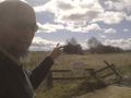
I then attempted to gain access to the sand/gravel quarry to get a picture from there. I did not want to approach the quarry office as this would require some explanations that I was not willing to give. So, I followed a truck along the quarry access road until I came to the quarry's engineering area, and got another picture of the truck going to the quarry-face with windmills in the background. The drive back along the access road was without the truck's dust, and much more pleasant.
My camera decided to not synch with the computer, so I'll put the pictures up when it does.
Photos
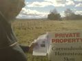
Gate to "Private Property"
Truck heading to the quarry-face. windmills in distance.
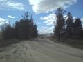
The two objectives were that way!


Achievements
Is it true that this user earned the No trespassing consolation prize?
|