Difference between revisions of "2012-08-03 41 -88"
From Geohashing
imported>Haberdasher (Created page with "{{meetup graticule | lat=41 | lon=-88 | date=2012-08-03 | graticule_name=Aurora | graticule_link=Aurora, Illinois }} == Location == Today's location is on the edge of the road ...") |
imported>FippeBot m (Location) |
||
| (3 intermediate revisions by one other user not shown) | |||
| Line 22: | Line 22: | ||
== Expedition == | == Expedition == | ||
| − | + | This hash was pretty easy. On the way back from a family friend's house, not far into a yard, and it gave us an excuse to drive by some pretty houses. No GPS was used, just the image and directions from Google Maps. A car was directly over what appeared to be the hashpoint- likely the same car over it in the Google Maps pictures- but I was able to get close enough to call this expedition a success. | |
== Pictures == | == Pictures == | ||
| Line 28: | Line 28: | ||
<gallery widths=117px perrow="5"> | <gallery widths=117px perrow="5"> | ||
| + | Image:2012-08-03_41_-88GoogleMaps.jpg | Google Maps image of hashpoint | ||
| + | Image:2012-08-03_41_-88House.jpg | House next to hash | ||
| + | Image:2012-08-03_41_-88Hashcar.jpg | Hashcar! | ||
| + | Image:2012-08-03_41_-88StupidGrinDistance.jpg | Stupid grin from afar | ||
| + | Image:2012-08-03_41_-88StupidGrinClose.jpg | Stupid grin close up | ||
| Line 34: | Line 39: | ||
== Achievements == | == Achievements == | ||
| + | {{No_batteries_geohash | ||
| + | | latitude = 41 | ||
| + | | longitude = -88 | ||
| + | | date = 2012-08-03 | ||
| + | | name = Haberdasher | ||
| + | }} | ||
| − | [[Category: | + | [[Category:Expeditions]] |
| + | [[Category:Expeditions with photos]] | ||
| + | [[Category:Coordinates reached]] | ||
| + | {{location|US|IL|DU}} | ||
Latest revision as of 05:22, 13 August 2019
| Fri 3 Aug 2012 in Aurora: 41.8850048, -88.0530051 geohashing.info google osm bing/os kml crox |
Location
Today's location is on the edge of the road in a residential neighborhood in Glen Ellyn.
Planning
Haberdasher is going to head there around 3:30 PM. -Haberdasher 15:38, 3 August 2012 (EDT)
Participants
Expedition
This hash was pretty easy. On the way back from a family friend's house, not far into a yard, and it gave us an excuse to drive by some pretty houses. No GPS was used, just the image and directions from Google Maps. A car was directly over what appeared to be the hashpoint- likely the same car over it in the Google Maps pictures- but I was able to get close enough to call this expedition a success.
Pictures
Google Maps image of hashpoint
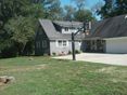
House next to hash
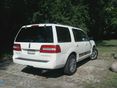
Hashcar!

Stupid grin from afar

Stupid grin close up


Achievements
Haberdasher earned the No Batteries Geohash Achievement
|