Difference between revisions of "2012-08-10 32 -117"
imported>JesseW (Created page with "{{subst:Expedition|date=2012-08-10|lat=32|lon=-117}}") |
imported>FippeBot m (Location) |
||
| (18 intermediate revisions by 3 users not shown) | |||
| Line 1: | Line 1: | ||
| − | |||
<!-- If you did not specify these parameters in the template, please substitute appropriate values for IMAGE, LAT, LON, and DATE (YYYY-MM-DD format) | <!-- If you did not specify these parameters in the template, please substitute appropriate values for IMAGE, LAT, LON, and DATE (YYYY-MM-DD format) | ||
| Line 19: | Line 18: | ||
== Location == | == Location == | ||
<!-- where you've surveyed the hash to be --> | <!-- where you've surveyed the hash to be --> | ||
| + | In front of 2854 Luna Avenue, San Diego. | ||
== Participants == | == Participants == | ||
<!-- who attended: If you link to your wiki user name in this section, your expedition will be picked up by the various statistics generated for geohashing. You may use three tildes ~ as a shortcut to automatically insert the user signature of the account you are editing with. | <!-- who attended: If you link to your wiki user name in this section, your expedition will be picked up by the various statistics generated for geohashing. You may use three tildes ~ as a shortcut to automatically insert the user signature of the account you are editing with. | ||
--> | --> | ||
| + | [[User:JesseW|JesseW]] 12:01, 10 August 2012 (EDT) <br> | ||
| + | [[User:Mathgeek|Todd (Mathgeek)]] 12:08, 10 August 2012 (EDT)<br> | ||
| + | [[User:LucasBrown|LucasBrown]] 18:40, 2012-08-10 | ||
== Plans == | == Plans == | ||
<!-- what were the original plans --> | <!-- what were the original plans --> | ||
| + | [[User:JesseW|JesseW]]: It's a 10 minute drive from my house, how can I not go. I plan to drive over this morning, and be there by about 9:30 AM. <br> | ||
| + | <br> | ||
| + | I should be able to swing by on the way home from work. -- [[User:Mathgeek|Mathgeek]] 09:09, 10 August 2012 (PDT)<br> | ||
== Expedition == | == Expedition == | ||
<!-- how it all turned out. your narrative goes here. --> | <!-- how it all turned out. your narrative goes here. --> | ||
| + | * I arrived at about 9:30 AM, after taking a somewhat circuitous route, and getting lost in the small curvey streets of Claremont Mesa. (I have no GPS device most of the time, including on this expedition.) I took a few pictures of the house, then left a copy of the [[Ambassador sheet]] with a note explaining why random people would be showing up in front of their house today. Pictures to come. (Eventually...) [[User:JesseW|JesseW]] 01:59, 11 August 2012 (EDT) | ||
| + | *I am here.... Nice neighborhood. -- [[User:Mathgeek|Mathgeek]] [http://www.openstreetmap.org/?lat=32.83471562&lon=-117.22356340&zoom=16&layers=B000FTF @32.8347,-117.2236] 16:49, 10 August 2012 (PDT) | ||
== Tracklog == | == Tracklog == | ||
<!-- if your GPS device keeps a log, you may post a link here --> | <!-- if your GPS device keeps a log, you may post a link here --> | ||
| Line 37: | Line 45: | ||
Image:2010-##-## ## ## Alpha.jpg | Witty Comment | Image:2010-##-## ## ## Alpha.jpg | Witty Comment | ||
--> | --> | ||
| − | <gallery | + | <gallery> |
| + | Image:2012-08-10_32_-117_18-37-54-568.jpg | Geohash Droid details page at the hashpoint ([[User:LucasBrown|LucasBrown]]) [http://www.openstreetmap.org/?lat=32.83472249&lon=-117.22355465&zoom=16&layers=B000FTF @32.8347,-117.2236] | ||
| + | |||
| + | Image:2012-08-10_32_-117_18-38-33-770.jpg | Geohash Droid map at the hashpoint ([[User:LucasBrown|LucasBrown]]) [http://www.openstreetmap.org/?lat=32.83472066&lon=-117.22353637&zoom=16&layers=B000FTF @32.8347,-117.2235] | ||
| + | |||
| + | Image:2012-08-10 32 -117 1 Mt Soladad Cross visible.jpg | The [https://en.wikipedia.org/wiki/Mount_Soledad_cross_controversy Mt. Soledad Cross] is very visible from this neighborhood. | ||
| + | Image:2012-08-10 32 -117 2 The driveway.jpg | This is the driveway where the hash point is. | ||
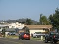
| + | Image:2012-08-10 32 -117 3 The house.jpg | This is the house whose driveway contains the hash point. | ||
| + | Image:2012-08-10 32 -117 4 The hash.jpg | This is (as far as JesseW's lack of a GPS can tell) the hash point. | ||
| + | Image:2012-08-10 32 -117 5 The Silly Grin.jpg | This is JesseW's requisite Silly (not so much of a) Grin. | ||
</gallery> | </gallery> | ||
== Achievements == | == Achievements == | ||
{{#vardefine:ribbonwidth|800px}} | {{#vardefine:ribbonwidth|800px}} | ||
| + | {{land geohash | latitude = 32 | longitude = -117 | date = 2012-08-10 | name = [[User:JesseW|JesseW]]}} | ||
| + | |||
<!-- Add any achievement ribbons you earned below, or remove this section --> | <!-- Add any achievement ribbons you earned below, or remove this section --> | ||
| − | |||
| − | |||
| − | |||
| − | |||
| − | |||
| − | |||
| − | |||
| − | |||
| − | |||
| − | |||
| − | |||
| − | |||
[[Category:Expeditions]] | [[Category:Expeditions]] | ||
| − | |||
[[Category:Expeditions with photos]] | [[Category:Expeditions with photos]] | ||
| − | |||
| − | |||
| − | |||
| − | |||
| − | |||
[[Category:Coordinates reached]] | [[Category:Coordinates reached]] | ||
| − | + | {{location|US|CA|SD}} | |
| − | |||
| − | |||
| − | |||
| − | |||
| − | |||
| − | |||
| − | |||
| − | |||
| − | |||
| − | |||
| − | |||
| − | |||
| − | |||
| − | |||
| − | |||
| − | |||
| − | |||
Latest revision as of 05:29, 13 August 2019
| Fri 10 Aug 2012 in 32,-117: 32.8347024, -117.2235842 geohashing.info google osm bing/os kml crox |
Location
In front of 2854 Luna Avenue, San Diego.
Participants
JesseW 12:01, 10 August 2012 (EDT)
Todd (Mathgeek) 12:08, 10 August 2012 (EDT)
LucasBrown 18:40, 2012-08-10
Plans
JesseW: It's a 10 minute drive from my house, how can I not go. I plan to drive over this morning, and be there by about 9:30 AM.
I should be able to swing by on the way home from work. -- Mathgeek 09:09, 10 August 2012 (PDT)
Expedition
- I arrived at about 9:30 AM, after taking a somewhat circuitous route, and getting lost in the small curvey streets of Claremont Mesa. (I have no GPS device most of the time, including on this expedition.) I took a few pictures of the house, then left a copy of the Ambassador sheet with a note explaining why random people would be showing up in front of their house today. Pictures to come. (Eventually...) JesseW 01:59, 11 August 2012 (EDT)
- I am here.... Nice neighborhood. -- Mathgeek @32.8347,-117.2236 16:49, 10 August 2012 (PDT)
Tracklog
Photos
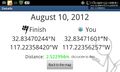
Geohash Droid details page at the hashpoint (LucasBrown) @32.8347,-117.2236
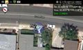
Geohash Droid map at the hashpoint (LucasBrown) @32.8347,-117.2235
The Mt. Soledad Cross is very visible from this neighborhood.
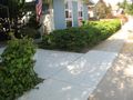
This is the driveway where the hash point is.
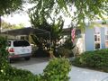
This is the house whose driveway contains the hash point.
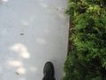
This is (as far as JesseW's lack of a GPS can tell) the hash point.

This is JesseW's requisite Silly (not so much of a) Grin.


Achievements
JesseW earned the Land geohash achievement
|