Difference between revisions of "2012-08-15 50 2"
imported>Zertrin (Coordinates reached, graticule deflowered) |
m (per Renaming Proposal) |
||
| (2 intermediate revisions by 2 users not shown) | |||
| Line 17: | Line 17: | ||
__NOTOC__ | __NOTOC__ | ||
== Location == | == Location == | ||
| − | + | In a wheat field of the countryside of Nord-Pas-de-Calais, near a little road. | |
== Participants == | == Participants == | ||
| Line 24: | Line 24: | ||
== Plans == | == Plans == | ||
| − | + | Convince my mother to make a 10 km detour on our way to the coast to reach the hash. | |
== Expedition == | == Expedition == | ||
| − | + | We departed a bit late from home, but I managed to convice her to make this detour as we were not that bound by time. | |
| + | |||
| + | Reaching the hash was quite easy as the wheat field had been cut recently. I took quickly a photo of my GPS and one of the landscape before jumping back into the car to continue our journey. | ||
| + | |||
| + | But some hundred meters after we left, while trying to check the pictures taken, I discovered with horror that I had forgotten to put back the memory card in my camera... Fortunately I had the other one with me so we went back and I took quickly two pictures at the hashpoint before going back into the car. | ||
== Tracklog == | == Tracklog == | ||
| Line 40: | Line 44: | ||
{{#vardefine:ribbonwidth|800px}} | {{#vardefine:ribbonwidth|800px}} | ||
<!-- Add any achievement ribbons you earned below, or remove this section --> | <!-- Add any achievement ribbons you earned below, or remove this section --> | ||
| − | {{ | + | {{Graticule unlocked |
| latitude = 50 | | latitude = 50 | ||
| longitude = 2 | | longitude = 2 | ||
| Line 59: | Line 63: | ||
[[Category:Expeditions with photos]] | [[Category:Expeditions with photos]] | ||
[[Category:Coordinates reached]] | [[Category:Coordinates reached]] | ||
| + | {{location|FR|62}} | ||
Latest revision as of 05:33, 20 March 2024
| Wed 15 Aug 2012 in 50,2: 50.3082822, 2.4382585 geohashing.info google osm bing/os kml crox |
Location
In a wheat field of the countryside of Nord-Pas-de-Calais, near a little road.
Participants
- User:Zertrin
- His mother
Plans
Convince my mother to make a 10 km detour on our way to the coast to reach the hash.
Expedition
We departed a bit late from home, but I managed to convice her to make this detour as we were not that bound by time.
Reaching the hash was quite easy as the wheat field had been cut recently. I took quickly a photo of my GPS and one of the landscape before jumping back into the car to continue our journey.
But some hundred meters after we left, while trying to check the pictures taken, I discovered with horror that I had forgotten to put back the memory card in my camera... Fortunately I had the other one with me so we went back and I took quickly two pictures at the hashpoint before going back into the car.
Tracklog
Photos
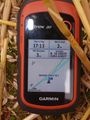
GPS Proof
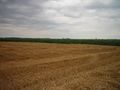
The landscape


Achievements
Zertrin earned the Graticule Unlocked Achievement
|
Zertrin earned the Drag-along achievement
|