Difference between revisions of "2012-09-15 50 13"
imported>Ravise (page creation) |
imported>FippeBot m (Location) |
||
| (3 intermediate revisions by one other user not shown) | |||
| Line 1: | Line 1: | ||
| − | |||
<!-- If you did not specify these parameters in the template, please substitute appropriate values for IMAGE, LAT, LON, and DATE (YYYY-MM-DD format) | <!-- If you did not specify these parameters in the template, please substitute appropriate values for IMAGE, LAT, LON, and DATE (YYYY-MM-DD format) | ||
| Line 17: | Line 16: | ||
<!-- edit as necessary --> | <!-- edit as necessary --> | ||
__NOTOC__ | __NOTOC__ | ||
| + | '''Warning: My english is not as good as I want. Page may contain non-existing words and bad prepositions. I apologize.''' | ||
== Location == | == Location == | ||
| − | + | My first hash looked simple: it was situated at playground in city Klášterec nad Ohří | |
== Participants == | == Participants == | ||
| − | + | [[User:Ravise|Ravise]] | |
| − | |||
| − | |||
== Plans == | == Plans == | ||
| − | + | Plan was simple too: take train from Most to Klášterec on 14:08 (arriving on 14:51) and train back on 15:42. That means I'd an hour to get to hashpoint and back. | |
== Expedition == | == Expedition == | ||
| − | + | I entered Klášterec on time. I have been to Klášterec few times before (not at hashpoint, unfortainetly) so I was pretty sure how to get to swimming pool, because hashpoint was nearby, just cross street and few more metres. But I took two or three bad turns and I was in part of Klášterec I've never been before! Watch the time... | |
| + | |||
| + | Suddenly swimming pool appeared. Hashpoint was at playground, but sattelite view didn't show me any fence. Here is one and it's pretty long. No, my first expedition will not end by "No public acces"... Or will? Hang on, that building is school! Playground should be opened. And it was. I took happily photos of hashpoint and left, because time was pressing me. | ||
| − | + | In quarter of my journy back to railway station I released I had forgotten to hang a poster! So I ran back, put there poster, photographed it and ran back to station. I luckily took the train few seconds before it leaved. | |
| − | |||
| + | My first hash looked simple... | ||
== Photos == | == Photos == | ||
| − | < | + | |
| − | + | <gallery perrow="4"> | |
| − | -- | + | File:2012-09-15 maly 1.JPG | I'm leaving |
| − | + | File:2012-09-15 maly 7.JPG | School in Klášterec. Luckily they own the playground (?) | |
| + | File:2012-09-15 maly 3.JPG | I may enter hashpoint | ||
| + | File:2012-09-15 maly 9.JPG | Hashpoint in detail | ||
| + | File:2012-09-15 maly 2.JPG | I know this wierd guy... | ||
| + | File:2012-09-15 maly 8.JPG | Forgotten poster | ||
| + | File:2012-09-15 maly 5.jpeg | Significant tree | ||
</gallery> | </gallery> | ||
| + | |||
== Achievements == | == Achievements == | ||
| − | {{ | + | {{land geohash |
| − | + | | latitude = 50 | |
| + | | longitude = 13 | ||
| + | | date = 2012-09-15 | ||
| + | | name = Ravise | ||
| + | }} | ||
| + | {{No_batteries_geohash | ||
| + | | latitude = 50 | ||
| + | | longitude = 13 | ||
| + | | date = 2012-09-15 | ||
| + | | name = Ravise | ||
| + | }} | ||
| − | |||
| − | |||
| − | |||
| − | |||
| − | |||
| − | |||
| − | |||
| − | |||
| − | |||
| − | |||
[[Category:Expeditions]] | [[Category:Expeditions]] | ||
| − | |||
[[Category:Expeditions with photos]] | [[Category:Expeditions with photos]] | ||
| − | |||
[[Category:Expedition without GPS]] | [[Category:Expedition without GPS]] | ||
| − | |||
| − | |||
| − | |||
[[Category:Coordinates reached]] | [[Category:Coordinates reached]] | ||
| − | + | {{location|CZ|US|2}} | |
| − | |||
| − | |||
| − | |||
| − | |||
| − | |||
| − | |||
| − | |||
| − | |||
| − | |||
| − | |||
| − | |||
| − | |||
| − | |||
| − | |||
| − | |||
| − | |||
| − | |||
Latest revision as of 06:06, 13 August 2019
| Sat 15 Sep 2012 in 50,13: 50.3909236, 13.1767951 geohashing.info google osm bing/os kml crox |
Warning: My english is not as good as I want. Page may contain non-existing words and bad prepositions. I apologize.
Location
My first hash looked simple: it was situated at playground in city Klášterec nad Ohří
Participants
Plans
Plan was simple too: take train from Most to Klášterec on 14:08 (arriving on 14:51) and train back on 15:42. That means I'd an hour to get to hashpoint and back.
Expedition
I entered Klášterec on time. I have been to Klášterec few times before (not at hashpoint, unfortainetly) so I was pretty sure how to get to swimming pool, because hashpoint was nearby, just cross street and few more metres. But I took two or three bad turns and I was in part of Klášterec I've never been before! Watch the time...
Suddenly swimming pool appeared. Hashpoint was at playground, but sattelite view didn't show me any fence. Here is one and it's pretty long. No, my first expedition will not end by "No public acces"... Or will? Hang on, that building is school! Playground should be opened. And it was. I took happily photos of hashpoint and left, because time was pressing me.
In quarter of my journy back to railway station I released I had forgotten to hang a poster! So I ran back, put there poster, photographed it and ran back to station. I luckily took the train few seconds before it leaved.
My first hash looked simple...
Photos
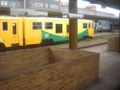
I'm leaving
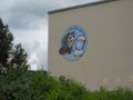
School in Klášterec. Luckily they own the playground (?)
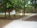
I may enter hashpoint
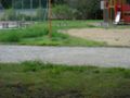
Hashpoint in detail

I know this wierd guy...
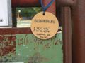
Forgotten poster
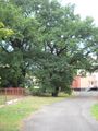
Significant tree


Achievements
Ravise earned the Land geohash achievement
|
Ravise earned the No Batteries Geohash Achievement
|