Difference between revisions of "2012-09-21 50 8"
imported>Rincewind (Just to get Mampfred happy.) |
imported>FippeBot m (Location) |
||
| (3 intermediate revisions by one other user not shown) | |||
| Line 20: | Line 20: | ||
We drove off the Autobahn and got directly onto the rural road beside which the hash was. A field road brought us within 90m or so from the coordinates, and we were lucky- while we previously hoped it would be on a harvested field, it was between a harvested field and a corn field in full growth, on a small grass way (or maybe, just the border between the fields?). Since it was mown, we didn't even get our shoes dirty and just had to walk straight on, make the necessary photes and head back. | We drove off the Autobahn and got directly onto the rural road beside which the hash was. A field road brought us within 90m or so from the coordinates, and we were lucky- while we previously hoped it would be on a harvested field, it was between a harvested field and a corn field in full growth, on a small grass way (or maybe, just the border between the fields?). Since it was mown, we didn't even get our shoes dirty and just had to walk straight on, make the necessary photes and head back. | ||
| − | This was | + | This was almost too easy. :) |
== Photos == | == Photos == | ||
<gallery perrow="5"> | <gallery perrow="5"> | ||
| − | image: | + | image:2012-09-21 50 8 hashproof.jpg|Hashproof |
| + | image:2012-09-21 50 8 hashdance.jpg|Trying to hit the spot... | ||
| + | image:2012-09-21 50 8 hashgrin.jpg|Unfocused grin | ||
</gallery> | </gallery> | ||
| Line 33: | Line 35: | ||
{{land geohash | {{land geohash | ||
| − | | latitude = | + | | latitude = 50 |
| longitude = 8 | | longitude = 8 | ||
| − | | date = 2012-09- | + | | date = 2012-09-21 |
| name = Yakamoz and Rincewind | | name = Yakamoz and Rincewind | ||
}} | }} | ||
| Line 42: | Line 44: | ||
[[Category:Expeditions with photos]] | [[Category:Expeditions with photos]] | ||
[[Category:Coordinates reached]] | [[Category:Coordinates reached]] | ||
| + | {{location|DE|HE|FB}} | ||
Latest revision as of 06:13, 13 August 2019
| Fri 21 Sep 2012 in 50,8: 50.4302360, 8.7126409 geohashing.info google osm bing/os kml crox |
Location
On a field near Butzbach, Hessen.
Participants
Plans
Independently, Yakamoz and Rincewind considered to visit this close-by hash on the way to Darmstadt. Hence, the discussion whether to attempt this one was rather short- as was the detour.
Expedition
We drove off the Autobahn and got directly onto the rural road beside which the hash was. A field road brought us within 90m or so from the coordinates, and we were lucky- while we previously hoped it would be on a harvested field, it was between a harvested field and a corn field in full growth, on a small grass way (or maybe, just the border between the fields?). Since it was mown, we didn't even get our shoes dirty and just had to walk straight on, make the necessary photes and head back.
This was almost too easy. :)
Photos
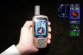
Hashproof

Trying to hit the spot...

Unfocused grin


Achievements
Yakamoz and Rincewind earned the Land geohash achievement
|