Difference between revisions of "2012-09-23 42 -89"
imported>RocketMac |
imported>FippeBot m (Location) |
||
| (4 intermediate revisions by 2 users not shown) | |||
| Line 25: | Line 25: | ||
== Photos == | == Photos == | ||
| − | + | ||
| − | |||
| − | |||
<gallery perrow="5"> | <gallery perrow="5"> | ||
| + | Image:RocketMac 2012-09-23 42 -89 01.jpg | Stupid Grin | ||
| + | Image:RocketMac 2012-09-23 42 -89 02.jpg | Every hash in central Illinois is in corn | ||
| + | Image:RocketMac 2012-09-23 42 -89 03.jpg | Careful... | ||
| + | Image:RocketMac 2012-09-23 42 -89 04.jpg | Not helping... | ||
| + | Image:RocketMac 2012-09-23 42 -89 06.jpg | Two hashes | ||
| + | Image:RocketMac 2012-09-23 42 -89 07.jpg | The distance between them | ||
</gallery> | </gallery> | ||
== Achievements == | == Achievements == | ||
{{#vardefine:ribbonwidth|800px}} | {{#vardefine:ribbonwidth|800px}} | ||
| + | {{land geohash | ||
| + | | latitude = 42 | ||
| + | | longitude = -89 | ||
| + | | date = 2012-09-23 | ||
| + | | name = RocketMac | ||
| + | | image = | ||
| + | }} | ||
| + | {{Déjà vu geohash | ||
| + | | latitude = 42 | ||
| + | | longitude = -89 | ||
| + | | date = 2012-09-23 | ||
| + | | olddate = [[2012-06-22 42 -89|2012-06-22]] | ||
| + | | name = RocketMac | ||
| + | | image = | ||
| + | }} | ||
| + | {{Minesweeper geohash | ||
| + | | graticule = Schaumburg, Illinois | ||
| + | | ranknumber = 8 | ||
| + | | n = true | ||
| + | | ne = true | ||
| + | | e = true | ||
| + | | se = true | ||
| + | | s = true | ||
| + | | sw = true | ||
| + | | w = true | ||
| + | | nw = true | ||
| + | | name = RocketMac | ||
| + | }} | ||
| − | |||
| − | |||
[[Category:Expeditions]] | [[Category:Expeditions]] | ||
[[Category:Expeditions with photos]] | [[Category:Expeditions with photos]] | ||
[[Category:Coordinates reached]] | [[Category:Coordinates reached]] | ||
| + | {{location|US|IL|OG}} | ||
Latest revision as of 05:13, 6 August 2019
| Sun 23 Sep 2012 in 42,-89: 42.0059613, -89.0873957 geohashing.info google osm bing/os kml crox |
Location
A corn field in White Rock, IL
Participants
Plans
I'm working in St. Louis this week and driving down today.
Expedition
This was my second attempt at a hash in this graticule during a St. Louis work trip. This one was only a couple of miles from the highway, so the detour wasn't too bad. As I approached the spot, I thought the area looked familiar. Then I realized I had passed this sign before. I checked and my GPS still had the last marker on it.
This means I can prove I've been here! My tracklog from the last attempt will show it.
I completed my Minesweeper Geohash and earned the Déjà VuGeohash as well!
Tracklog
My GPS tracklog is available in GPX and KMZ formats.
Photos

Stupid Grin
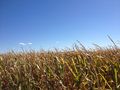
Every hash in central Illinois is in corn
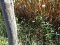
Careful...

Not helping...
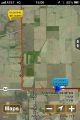
Two hashes
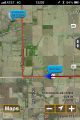
The distance between them


Achievements
RocketMac earned the Land geohash achievement
|
RocketMac earned the Déjà Vu Geohash Achievement
|
RocketMac completed the Minesweeper Geohash achievement
|