Difference between revisions of "2012-10-13 32 -116"
From Geohashing
imported>LucasBrown (→Participants) |
imported>FippeBot m (Location) |
||
| (4 intermediate revisions by 2 users not shown) | |||
| Line 1: | Line 1: | ||
| − | + | {{meetup graticule | lat=32 | lon=-116 | date=2012-10-13}} | |
| − | |||
| − | |||
| − | |||
| − | |||
| − | |||
| − | |||
| − | |||
| − | |||
| − | |||
| − | |||
| − | |||
| − | |||
| − | |||
| − | |||
__NOTOC__ | __NOTOC__ | ||
== Location == | == Location == | ||
| − | Under a Chinese Lantern tree on Trailridge Drive | + | Under a Chinese Lantern tree on Trailridge Drive, Chula Vista |
== Participants == | == Participants == | ||
[[User:LucasBrown|LucasBrown]] reached the hashpoint at 14:16 PDT. | [[User:LucasBrown|LucasBrown]] reached the hashpoint at 14:16 PDT. | ||
| − | |||
| − | |||
| − | |||
| − | |||
| − | |||
| − | |||
== Photos == | == Photos == | ||
<gallery perrow="5"> | <gallery perrow="5"> | ||
| − | + | Image:2012-10-13_32_-116_14-24-42-390.jpg | Geohash Droid details page at the hashpoint [http://www.openstreetmap.org/?lat=32.66896949&lon=-117.00989482&zoom=16&layers=B000FTF @32.6690,-117.0099] | |
| − | Image:2012-10-13_32_-116_14-24-42-390.jpg | | + | Image:2012-10-13_32_-116_14-25-24-076.jpg | Geohash Droid map at the hashpoint [http://www.openstreetmap.org/?lat=32.67180893&lon=-117.01210268&zoom=16&layers=B000FTF @32.6718,-117.0121] |
| − | |||
| − | Image:2012-10-13_32_-116_14-25-24-076.jpg | | ||
| − | |||
Image:2012-10-13_32_-116_14-28-59-823.jpg | The hashpoint is under this tree. [http://www.openstreetmap.org/?lat=32.65450000&lon=-116.99600000&zoom=16&layers=B000FTF @32.6545,-116.9960] | Image:2012-10-13_32_-116_14-28-59-823.jpg | The hashpoint is under this tree. [http://www.openstreetmap.org/?lat=32.65450000&lon=-116.99600000&zoom=16&layers=B000FTF @32.6545,-116.9960] | ||
</gallery> | </gallery> | ||
| − | |||
| − | |||
| − | |||
| − | |||
[[Category:Expeditions]] | [[Category:Expeditions]] | ||
[[Category:Expeditions with photos]] | [[Category:Expeditions with photos]] | ||
[[Category:Expedition without GPS]] | [[Category:Expedition without GPS]] | ||
[[Category:Coordinates reached]] | [[Category:Coordinates reached]] | ||
| + | {{location|US|CA|SD}} | ||
Latest revision as of 06:29, 13 August 2019
| Sat 13 Oct 2012 in 32,-116: 32.6545215, -116.9964695 geohashing.info google osm bing/os kml crox |
Location
Under a Chinese Lantern tree on Trailridge Drive, Chula Vista
Participants
LucasBrown reached the hashpoint at 14:16 PDT.
Photos
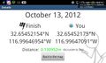
Geohash Droid details page at the hashpoint @32.6690,-117.0099
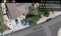
Geohash Droid map at the hashpoint @32.6718,-117.0121
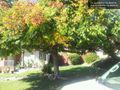
The hashpoint is under this tree. @32.6545,-116.9960


