Difference between revisions of "2012-11-29 -35 149"
imported>1PE (→Photos) |
imported>FippeBot m (Location) |
||
| (One intermediate revision by one other user not shown) | |||
| Line 1: | Line 1: | ||
| − | |||
| − | [[Image:{{{image| | + | [[Image:{{{image|2012-11-29_-35_149a.jpg}}}|thumb|left]] |
| − | |||
| − | |||
| − | |||
| − | |||
| − | |||
| − | |||
{{meetup graticule | {{meetup graticule | ||
| lat=-35 | | lat=-35 | ||
| Line 50: | Line 43: | ||
[[Category:Expedition without GPS]] | [[Category:Expedition without GPS]] | ||
[[Category:Coordinates reached]] | [[Category:Coordinates reached]] | ||
| + | {{location|AU|ACT}} | ||
Latest revision as of 00:03, 14 August 2019

| Thu 29 Nov 2012 in -35,149: -35.1625608, 149.0977453 geohashing.info google osm bing/os kml crox |
Location
On the road surface of a parking bay on the north-bound lane (western side -- this is Australia!) of Plimsoll Drive (off Springbank Rise), a divided (separate up-down) suburban through-road in the new suburb of Casey in the developing Gungahlin town centre of Canberra.
Participants
1PE
Plans
1PE
On the way home from work, probably about 5.30pm. This will be a "drive-by" with pictures. However, as the site is quite close to the end of the dedicated parking bay, the fastest practical drive-by through the hash will be at very low speed. Of course, there might be a car parked right at the spot, and then I'll put a Geohash brochure under the windscreen wiper and get a pic of that.
Expedition
1PE
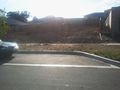
I drove to where I thought the suburb was, but had taken a wrong turn somewhere as "all the new suburbs look alike". When I finally got to the hash point, the parking bay was clear so I parked just behind the spot and then took some pictures of the hash point, the building site beside the spot and the large tree over the road. I put a printed version of this page in the letterbox of the nearest house. To leave the spot, I "drove through" the hash point as I left the parking bay and returned to the roadway.
Tracklog
Photos
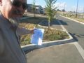
A small park beside the car park hash.
A car park hash
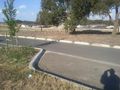
A tree and a view from the hash.

