Difference between revisions of "2012-12-01 55 37"
From Geohashing
imported>Camomilesson (An expedition message sent via Geohash Droid for Android.) |
imported>FippeBot m (Location) |
||
| (19 intermediate revisions by 2 users not shown) | |||
| Line 1: | Line 1: | ||
| − | |||
<!-- If you did not specify these parameters in the template, please substitute appropriate values for IMAGE, LAT, LON, and DATE (YYYY-MM-DD format) | <!-- If you did not specify these parameters in the template, please substitute appropriate values for IMAGE, LAT, LON, and DATE (YYYY-MM-DD format) | ||
| Line 19: | Line 18: | ||
== Location == | == Location == | ||
<!-- where you've surveyed the hash to be --> | <!-- where you've surveyed the hash to be --> | ||
| + | On the territory of 68s City Hospital | ||
== Participants == | == Participants == | ||
| Line 30: | Line 30: | ||
<!-- how it all turned out. your narrative goes here. --> | <!-- how it all turned out. your narrative goes here. --> | ||
| + | |||
| + | *going to try to catch this Saturday's hash, which is in the city limit. | ||
| + | me and my beautiful blonde friend are going. | ||
| + | event on g+: https://plus.google.com/u/0/photos/114979523877825323770/albums/5810945116627620689?authkey=CKj218iXqqG9dg -- [[User:Camomilesson|camomilesson]] [http://www.openstreetmap.org/?lat=55.77243740&lon=37.61244180&zoom=16&layers=B000FTF @55.7724,37.6124] 02:17, 1 December 2012 (MSK) | ||
| + | |||
| + | *A friend of mine couldn't go, starting expedition alone on my trusty war-scooter Rocinante. -- [[User:Camomilesson|camomilesson]] [http://www.openstreetmap.org/?lat=55.75419010&lon=37.63671340&zoom=16&layers=B000FTF @55.7542,37.6367] 15:11, 1 December 2012 (MSK) | ||
| + | |||
| + | *The wind blew due west, and me and Rocinante couldn't but notice the sense of utmost desolation that reigned over this corroded wasteland. -- [[User:Camomilesson|camomilesson]] [http://www.openstreetmap.org/?lat=55.73057880&lon=37.67399610&zoom=16&layers=B000FTF @55.7306,37.6740] 15:33, 1 December 2012 (MSK) | ||
| + | |||
| + | *Strange structures loomed over the landscape, forbidding and forgotten. -- [[User:Camomilesson|camomilesson]] [http://www.openstreetmap.org/?lat=55.71343340&lon=37.71809310&zoom=16&layers=B000FTF @55.7134,37.7181] 15:44, 1 December 2012 (MSK) | ||
| + | |||
| + | *Rocinante reared, I sensed it too. All around us, hiding behind decayed constructions, were savages, living so close to the edge of the known land - The Moscow's Encircling Automobile Road. -- [[User:Camomilesson|camomilesson]] [http://www.openstreetmap.org/?lat=55.69370390&lon=37.75517380&zoom=16&layers=B000FTF @55.6937,37.7552] 15:59, 1 December 2012 (MSK) | ||
| + | |||
| + | *We were so close, I had to leave my steed behind, I hope no harm will come to it. -- [[User:Camomilesson|camomilesson]] [http://www.openstreetmap.org/?lat=55.69303880&lon=37.75400880&zoom=16&layers=B000FTF @55.6930,37.7540] 16:01, 1 December 2012 (MSK) | ||
| + | |||
| + | *I...I made it...it is beautiful... -- [[User:Camomilesson|camomilesson]] [http://www.openstreetmap.org/?lat=55.69284058&lon=37.75286484&zoom=16&layers=B000FTF @55.6928,37.7529] 16:05, 1 December 2012 (MSK) | ||
| + | |||
| + | |||
| + | *The day is gone but the journey continues. All in all it was a bloody great geohash. -- [[User:Camomilesson|camomilesson]] [http://www.openstreetmap.org/?lat=55.74146770&lon=37.56196620&zoom=16&layers=B000FTF @55.7415,37.5620] 19:48, 1 December 2012 (MSK) | ||
== Tracklog == | == Tracklog == | ||
<!-- if your GPS device keeps a log, you may post a link here --> | <!-- if your GPS device keeps a log, you may post a link here --> | ||
| Line 38: | Line 57: | ||
--> | --> | ||
<gallery perrow="5"> | <gallery perrow="5"> | ||
| + | |||
| + | Image:2012-12-01_55_37_15-15-05-837.jpg | Rocinante is uneasy, feeling winds of adventure on It's skinny hide. [http://www.openstreetmap.org/?lat=55.75417430&lon=37.63671850&zoom=16&layers=B000FTF @55.7542,37.6367] | ||
| + | |||
| + | Image:2012-12-01_55_37_15-45-17-646.jpg | Only mad heathen tribesmen could build this abomination. [http://www.openstreetmap.org/?lat=55.71327600&lon=37.71863090&zoom=16&layers=B000FTF @55.7133,37.7186] | ||
| + | |||
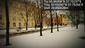
| + | Image:2012-12-01_55_37_15-45-55-598.jpg | The storm was coming. [http://www.openstreetmap.org/?lat=55.71334590&lon=37.71837590&zoom=16&layers=B000FTF @55.7133,37.7184] | ||
| + | |||
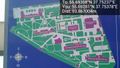
| + | Image:2012-12-01_55_37_16-08-07-488.jpg | My horse is tired, my feet are frozen, but it is beautiful. [http://www.openstreetmap.org/?lat=55.69292450&lon=37.75264740&zoom=16&layers=B000FTF @55.6929,37.7526] | ||
| + | |||
| + | Image:2012-12-01_55_37_16-08-31-375.jpg | [http://www.openstreetmap.org/?lat=55.69298935&lon=37.75258636&zoom=16&layers=B000FTF @55.6930,37.7526] | ||
| + | |||
| + | Image:2012-12-01_55_37_16-08-45-807.jpg | [http://www.openstreetmap.org/?lat=55.69302368&lon=37.75258636&zoom=16&layers=B000FTF @55.6930,37.7526] | ||
| + | |||
| + | Image:2012-12-01_55_37_16-14-20-803.jpg | Let the adventure times go [http://www.openstreetmap.org/?lat=55.69314957&lon=37.75241470&zoom=16&layers=B000FTF @55.6931,37.7524] | ||
| + | |||
| + | Image:2012-12-01_55_37_16-22-01-461.jpg | What do these runes mean? A map? But to what? [http://www.openstreetmap.org/?lat=55.69280620&lon=37.75377870&zoom=16&layers=B000FTF @55.6928,37.7538] | ||
</gallery> | </gallery> | ||
| Line 46: | Line 81: | ||
<!-- =============== USEFUL CATEGORIES FOLLOW ================ | <!-- =============== USEFUL CATEGORIES FOLLOW ================ | ||
| − | |||
| − | |||
| − | |||
| − | |||
| − | |||
| − | |||
--> | --> | ||
| − | |||
[[Category:Expeditions]] | [[Category:Expeditions]] | ||
| − | |||
[[Category:Expeditions with photos]] | [[Category:Expeditions with photos]] | ||
| − | |||
| − | |||
| − | |||
| − | |||
[[Category:Coordinates reached]] | [[Category:Coordinates reached]] | ||
| − | + | [[Category:Land geohash achievement]] | |
| − | + | {{location|RU|MOW}} | |
| − | |||
| − | |||
| − | [[Category: | ||
| − | |||
| − | |||
| − | |||
| − | |||
| − | |||
| − | |||
| − | |||
| − | |||
| − | |||
| − | |||
| − | |||
Latest revision as of 00:06, 14 August 2019
| Sat 1 Dec 2012 in 55,37: 55.6930827, 37.7523686 geohashing.info google osm bing/os kml crox |
Location
On the territory of 68s City Hospital
Participants
Plans
Expedition
- going to try to catch this Saturday's hash, which is in the city limit.
me and my beautiful blonde friend are going. event on g+: https://plus.google.com/u/0/photos/114979523877825323770/albums/5810945116627620689?authkey=CKj218iXqqG9dg -- camomilesson @55.7724,37.6124 02:17, 1 December 2012 (MSK)
- A friend of mine couldn't go, starting expedition alone on my trusty war-scooter Rocinante. -- camomilesson @55.7542,37.6367 15:11, 1 December 2012 (MSK)
- The wind blew due west, and me and Rocinante couldn't but notice the sense of utmost desolation that reigned over this corroded wasteland. -- camomilesson @55.7306,37.6740 15:33, 1 December 2012 (MSK)
- Strange structures loomed over the landscape, forbidding and forgotten. -- camomilesson @55.7134,37.7181 15:44, 1 December 2012 (MSK)
- Rocinante reared, I sensed it too. All around us, hiding behind decayed constructions, were savages, living so close to the edge of the known land - The Moscow's Encircling Automobile Road. -- camomilesson @55.6937,37.7552 15:59, 1 December 2012 (MSK)
- We were so close, I had to leave my steed behind, I hope no harm will come to it. -- camomilesson @55.6930,37.7540 16:01, 1 December 2012 (MSK)
- I...I made it...it is beautiful... -- camomilesson @55.6928,37.7529 16:05, 1 December 2012 (MSK)
- The day is gone but the journey continues. All in all it was a bloody great geohash. -- camomilesson @55.7415,37.5620 19:48, 1 December 2012 (MSK)
Tracklog
Photos
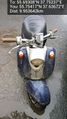
Rocinante is uneasy, feeling winds of adventure on It's skinny hide. @55.7542,37.6367
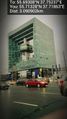
Only mad heathen tribesmen could build this abomination. @55.7133,37.7186

The storm was coming. @55.7133,37.7184
My horse is tired, my feet are frozen, but it is beautiful. @55.6929,37.7526

Let the adventure times go @55.6931,37.7524
What do these runes mean? A map? But to what? @55.6928,37.7538


