Difference between revisions of "1995-11-22 32 34"
imported>LiNaK |
imported>FippeBot m (Location) |
||
| (6 intermediate revisions by one other user not shown) | |||
| Line 12: | Line 12: | ||
| lon=34 | | lon=34 | ||
| date=1995-11-22 | | date=1995-11-22 | ||
| + | | retro=1 | ||
}} | }} | ||
<!-- edit as necessary --> | <!-- edit as necessary --> | ||
__NOTOC__ | __NOTOC__ | ||
| − | Origin geohash, taken on 8th of | + | Origin geohash, taken on 8th of December, 2012. |
== Location == | == Location == | ||
| − | + | Right at the end of HaPragim Street, Ramat Ef'al. | |
== Participants == | == Participants == | ||
<!-- who attended: If you link to your wiki user name in this section, your expedition will be picked up by the various statistics generated for geohashing. You may use three tildes ~ as a shortcut to automatically insert the user signature of the account you are editing with. | <!-- who attended: If you link to your wiki user name in this section, your expedition will be picked up by the various statistics generated for geohashing. You may use three tildes ~ as a shortcut to automatically insert the user signature of the account you are editing with. | ||
--> | --> | ||
| + | Omri ([[User:LiNaK|LinaK]]) | ||
== Plans == | == Plans == | ||
| − | + | I was eyeing this origin hash for quite some time, and it seemed perfect: only a short biking distance from home, in a settled area that shouldn't be off limits, and a path that is on safe pavements instead of on the main road. Hanuka holiday was a great opportunity for some geohashing, and as the hashes for the day were all hard to reach, this December Saturday seemed like the perfect time to go. | |
== Expedition == | == Expedition == | ||
| − | + | The weather was great for a nice bike ride- the skies clouded and the air cool and pretty dry, but no rain to spoil the fun. The path itself is a one I'm very much familiar with- the bit till Kiryat Ono is a one I bike everyday to school and the bit after it, around the military base and Tel HaShomer hospital wasn't as steep as I expected it to be, so I've reached Ramat Ef'al at no time. | |
| + | |||
| + | After [[2012-11-01 32 34|my previous hash]] it seemed like there is no sense in bringing that cursed GPS device again, after it had a nervous breakdown and left me at a middle of a field at night. Instead I drew myself a map of the small town and used it to get to the spot. Judging from the satellite image I can now say the point was on the road, right before the dead end, but when I was there it somehow seemed to me as if the point should be at the plant nursery, on the other side of the barbed, so I took a picture through the wire when I was actually standing exactly where I was supposed to be. Before turning back home I rode along the parallel streets to see if I could legally cross to other side somewhere (now I know I didn't even need to get there). | ||
| + | |||
| + | On the way back I took some more pictures along the way, just cause reports with a lot of pictures are much more fun. Most of the way I couldn't take pictures because of the military base (if the IDF put a sign that you can't take any pictures, you don't check to see if they're serious). Overall I think this was my easiest meetup so far- only 12.6 KM and less than 90 minutes for the whole thing, along a track I cycle nearly everyday, and no rain except for a few raindrops. | ||
| − | |||
| − | |||
== Photos == | == Photos == | ||
| Line 38: | Line 42: | ||
--> | --> | ||
<gallery perrow="5"> | <gallery perrow="5"> | ||
| + | Image:1995-11-22 32 34 map.jpg | Made a map for this one! | ||
| + | Image:1995-11-22 32 34 hash.jpg | The hashpoint is about where my bikes are. | ||
| + | Image:1995-11-22 32 34 fake.jpg | This is where I thought the hashpoint was. | ||
| + | Image:1995-11-22 32 34 art.jpg | This one is so bad it's actually artistic. | ||
| + | Image:1995-11-22 32 34 road.jpg | HaPragim Street | ||
| + | Image:1995-11-22 32 34 field.jpg | Field near Ramat Ef'al. | ||
| + | Image:1995-11-22 32 34 road.jpg | Why did I take a picture? I pass here every day | ||
| + | Image:1995-11-22 32 34 Ono.jpg | Entrance to Kiryat Ono | ||
| + | Image:1995-11-22 32 34 green.jpg | Unusually green and cloudy for this area | ||
</gallery> | </gallery> | ||
== Achievements == | == Achievements == | ||
{{#vardefine:ribbonwidth|800px}} | {{#vardefine:ribbonwidth|800px}} | ||
| − | + | {{origin geohash | |
| + | | latitude = 32 | ||
| + | | longitude = 34 | ||
| + | | date = 1995-11-22 | ||
| + | | on = 2012-12-08 | ||
| + | | name = ([[User:LiNaK|Omri]]) | ||
| + | | image = 1995-11-22 32 34 hash.jpg | ||
| + | }} | ||
<!-- =============== USEFUL CATEGORIES FOLLOW ================ | <!-- =============== USEFUL CATEGORIES FOLLOW ================ | ||
Delete the next line ONLY if you have chosen the appropriate categories below. If you are unsure, don't worry. People will read your report and help you with the classification. --> | Delete the next line ONLY if you have chosen the appropriate categories below. If you are unsure, don't worry. People will read your report and help you with the classification. --> | ||
| − | |||
| − | |||
| − | |||
| − | |||
| − | |||
| − | |||
| − | |||
| − | |||
| − | |||
| − | |||
| − | |||
| − | |||
| − | |||
| − | |||
| − | |||
| − | |||
| − | |||
| − | |||
| − | |||
| − | |||
| − | |||
| − | |||
| − | |||
| − | |||
| − | |||
| − | |||
| − | |||
| − | |||
| − | |||
| − | |||
| − | |||
| − | |||
| − | |||
| − | + | [[Category: Meetup in 32 34]] | |
| + | [[Category: Retro meetup]] | ||
| + | [[Category: Retro coordinates reached]] | ||
| + | {{location|IL|TA}} | ||
Latest revision as of 12:28, 14 July 2019
| Wed 22 Nov 1995 in 32,34: 32.0459296, 34.8393299 geohashing.info google osm bing/os kml crox |
Origin geohash, taken on 8th of December, 2012.
Location
Right at the end of HaPragim Street, Ramat Ef'al.
Participants
Omri (LinaK)
Plans
I was eyeing this origin hash for quite some time, and it seemed perfect: only a short biking distance from home, in a settled area that shouldn't be off limits, and a path that is on safe pavements instead of on the main road. Hanuka holiday was a great opportunity for some geohashing, and as the hashes for the day were all hard to reach, this December Saturday seemed like the perfect time to go.
Expedition
The weather was great for a nice bike ride- the skies clouded and the air cool and pretty dry, but no rain to spoil the fun. The path itself is a one I'm very much familiar with- the bit till Kiryat Ono is a one I bike everyday to school and the bit after it, around the military base and Tel HaShomer hospital wasn't as steep as I expected it to be, so I've reached Ramat Ef'al at no time.
After my previous hash it seemed like there is no sense in bringing that cursed GPS device again, after it had a nervous breakdown and left me at a middle of a field at night. Instead I drew myself a map of the small town and used it to get to the spot. Judging from the satellite image I can now say the point was on the road, right before the dead end, but when I was there it somehow seemed to me as if the point should be at the plant nursery, on the other side of the barbed, so I took a picture through the wire when I was actually standing exactly where I was supposed to be. Before turning back home I rode along the parallel streets to see if I could legally cross to other side somewhere (now I know I didn't even need to get there).
On the way back I took some more pictures along the way, just cause reports with a lot of pictures are much more fun. Most of the way I couldn't take pictures because of the military base (if the IDF put a sign that you can't take any pictures, you don't check to see if they're serious). Overall I think this was my easiest meetup so far- only 12.6 KM and less than 90 minutes for the whole thing, along a track I cycle nearly everyday, and no rain except for a few raindrops.
Photos
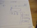
Made a map for this one!
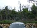
The hashpoint is about where my bikes are.
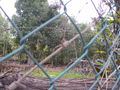
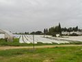
This is where I thought the hashpoint was.
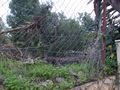
This one is so bad it's actually artistic.
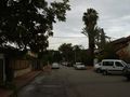
HaPragim Street
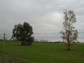
Field near Ramat Ef'al.
Why did I take a picture? I pass here every day
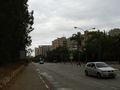
Entrance to Kiryat Ono
Unusually green and cloudy for this area


Achievements
(Omri) earned the Origin geohash achievement
|