Difference between revisions of "2013-01-07 32 -116"
From Geohashing
imported>LucasBrown |
imported>FippeBot m (Location) |
||
| (3 intermediate revisions by 2 users not shown) | |||
| Line 3: | Line 3: | ||
__NOTOC__ | __NOTOC__ | ||
== Location == | == Location == | ||
| − | + | Off Marguerite Canyon Drive, Lakeside, CA | |
== Participants == | == Participants == | ||
| Line 13: | Line 13: | ||
Image:2013-01-07_32_-116_15-00-27-747.jpg | Geohash Droid details page at the hashpoint | Image:2013-01-07_32_-116_15-00-27-747.jpg | Geohash Droid details page at the hashpoint | ||
Image:2013-01-07_32_-116_15-55-12-154.jpg | View near the hashpoint | Image:2013-01-07_32_-116_15-55-12-154.jpg | View near the hashpoint | ||
| + | Image:2013-01-07_32_-116_pano.jpg | Panorama from the road near the hashpoint; the hashpoint is approximately within the red circle. | ||
</gallery> | </gallery> | ||
| − | |||
[[Category:Expeditions]] | [[Category:Expeditions]] | ||
[[Category:Expeditions with photos]] | [[Category:Expeditions with photos]] | ||
[[Category:Expedition without GPS]] | [[Category:Expedition without GPS]] | ||
[[Category:Coordinates reached]] | [[Category:Coordinates reached]] | ||
| + | {{location|US|CA|SD}} | ||
Latest revision as of 00:32, 14 August 2019
| Mon 7 Jan 2013 in 32,-116: 32.8897323, -116.8669833 geohashing.info google osm bing/os kml crox |
Location
Off Marguerite Canyon Drive, Lakeside, CA
Participants
Photos
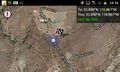
Map near the hashpoint
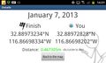
Geohash Droid details page at the hashpoint
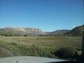
View near the hashpoint
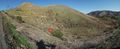
Panorama from the road near the hashpoint; the hashpoint is approximately within the red circle.


