Difference between revisions of "2013-01-11 50 8"
From Geohashing
imported>QuarterCacher (An expedition message sent via Geohash Droid for Android.) |
imported>FippeBot m (Location) |
||
| (5 intermediate revisions by 2 users not shown) | |||
| Line 1: | Line 1: | ||
| − | |||
| − | |||
| − | |||
| − | |||
| − | |||
| − | |||
| − | |||
| − | |||
| − | |||
| − | |||
{{meetup graticule | {{meetup graticule | ||
| lat=50 | | lat=50 | ||
| Line 15: | Line 5: | ||
}} | }} | ||
| − | |||
__NOTOC__ | __NOTOC__ | ||
== Location == | == Location == | ||
| − | + | In the woods not far from the Autobahn and the airport and a public lake which conventiently provided ample parking space for this expedition :D | |
== Participants == | == Participants == | ||
| − | + | * [[User:QuarterCacher|QuarterCacher]] | |
| − | + | * [[User:Mampfred|Mampfred]] | |
== Plans == | == Plans == | ||
| − | + | It's 2013 and we haven't hashed in ages. It's about time we get this hash year started! | |
== Expedition == | == Expedition == | ||
| − | + | We met up after work at the Sulzbach station. QuarterCacher drove to the parking at the lake and we walked a good three kilometers return. The hash was right on the path we chose so we didn't even get wet or muddy. Good start for the year :) | |
| + | |||
| + | Oh and it probably was just below freezing point but we can't prove it so there. We've walked 3.2km on this expedition. | ||
== Tracklog == | == Tracklog == | ||
| − | + | See [http://www.everytrail.com/view_trip.php?trip_id=1979406 here]. | |
== Photos == | == Photos == | ||
| − | |||
| − | |||
| − | |||
<gallery perrow="5"> | <gallery perrow="5"> | ||
| + | Image:2013-01-11_50_8_coordinates_reached.jpg | GPS says yes | ||
| + | Image:2013-01-11_50_8_17-58-05-432.jpg | Coordinates reached. Blind stupid grin. 0°C | ||
| + | Image:2013-01-11_50_8_autobahn_1.jpg | Crossing the Autobahn | ||
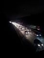
| + | Image:2013-01-11_50_8_autobahn_2.jpg | ||
</gallery> | </gallery> | ||
== Achievements == | == Achievements == | ||
{{#vardefine:ribbonwidth|800px}} | {{#vardefine:ribbonwidth|800px}} | ||
| − | + | * Land | |
| − | |||
| − | |||
| − | |||
| − | |||
| − | |||
| − | |||
| − | |||
| − | |||
| − | |||
| − | |||
| − | |||
[[Category:Expeditions]] | [[Category:Expeditions]] | ||
| − | |||
[[Category:Expeditions with photos]] | [[Category:Expeditions with photos]] | ||
| − | |||
| − | |||
| − | |||
| − | |||
| − | |||
[[Category:Coordinates reached]] | [[Category:Coordinates reached]] | ||
| − | + | {{location|DE|HE|GG}} | |
| − | |||
| − | |||
| − | |||
| − | |||
| − | |||
| − | |||
| − | |||
| − | |||
| − | |||
| − | |||
| − | |||
| − | |||
| − | |||
| − | |||
| − | |||
| − | |||
| − | |||
Latest revision as of 00:35, 14 August 2019
| Fri 11 Jan 2013 in 50,8: 50.0120581, 8.4960484 geohashing.info google osm bing/os kml crox |
Location
In the woods not far from the Autobahn and the airport and a public lake which conventiently provided ample parking space for this expedition :D
Participants
Plans
It's 2013 and we haven't hashed in ages. It's about time we get this hash year started!
Expedition
We met up after work at the Sulzbach station. QuarterCacher drove to the parking at the lake and we walked a good three kilometers return. The hash was right on the path we chose so we didn't even get wet or muddy. Good start for the year :)
Oh and it probably was just below freezing point but we can't prove it so there. We've walked 3.2km on this expedition.
Tracklog
See here.
Photos
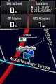
GPS says yes
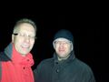
Coordinates reached. Blind stupid grin. 0°C
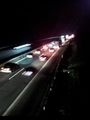
Crossing the Autobahn


Achievements
- Land