Difference between revisions of "2013-03-12 -35 149"
imported>1PE |
m (More specific location) |
||
| (3 intermediate revisions by 2 users not shown) | |||
| Line 47: | Line 47: | ||
image:2013-03-12_-35_149_shearing-shed.jpg|shearing shed, railway line to the right | image:2013-03-12_-35_149_shearing-shed.jpg|shearing shed, railway line to the right | ||
image:2013-03-12_-35_149_monuments.jpg|Ceremnial / monumental gates; both sies of near tree. | image:2013-03-12_-35_149_monuments.jpg|Ceremnial / monumental gates; both sies of near tree. | ||
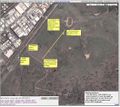
| + | image:2013-03-12_-35_149_Environa_overview.JPG|"Environa" overview of old planned suburb. | ||
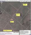
| + | image:2013-03-12_-35_149_Environa_ceremonial-road.JPG|Details of seremonial road with still-existing road markers per picture of field. | ||
</gallery> | </gallery> | ||
| Line 54: | Line 56: | ||
| − | |||
| − | |||
| − | |||
| − | |||
| − | |||
| − | |||
| − | |||
| − | |||
| − | |||
[[Category:Expeditions]] | [[Category:Expeditions]] | ||
| − | |||
[[Category:Expeditions with photos]] | [[Category:Expeditions with photos]] | ||
| − | + | ||
| − | |||
| − | |||
| − | |||
| − | |||
| − | |||
| − | |||
| − | |||
[[Category:Coordinates not reached]] | [[Category:Coordinates not reached]] | ||
| − | |||
| − | |||
| − | |||
| − | |||
| − | |||
[[Category:Not reached - No public access]] | [[Category:Not reached - No public access]] | ||
| − | + | {{location|AU|NSW|QB}} | |
| − | |||
| − | |||
| − | |||
| − | |||
| − | |||
| − | |||
| − | |||
Latest revision as of 12:33, 1 August 2020
| Tue 12 Mar 2013 in -35,149: -35.3972633, 149.1765148 geohashing.info google osm bing/os kml crox |
Location
In a field by a dam on the farm called "Environa", just south of Jerrabombera, a suburb of Queanbeyan near Canberra. Hence, on Canberra's 100th anniversary, the hash was in a "sheep paddock" which was what Canberra was 100 years ago.
Participants
Plans
1PE
Go over lunchtime, about 15km from work.
Expedition
I went to the Australian Capital Teritory's industrial suburb of Hume, where there is an access under the railway line onto the New South Wales (state) side of the border.
Immediately I got onto the road beside the rail line, I found two enormous road machines, a ggrader and a roller-compactor. They were fixing the road surface from the under=line access to the gate of "Environa" where the hash was in a field.
I drove up the road after the grader had made a 'pass', and stopped at the closed gate to Environa where a sign said that it was private property. I took several pictures and then watched as a car drove out to the gate. I spoke to the person, who was not part of the owner-family, saying about geohashing and saying that I was not going to trespass within the property.
At this time, both machines were ariving and the car went down the road with some difficulty. I chose to drive a little furthewr and get some pictures of the sheep shearing shed on the farm. I then followed the machines slowly down the track, and got out to take some further pictures over Envrona where I saw some ceremonial gates in the field.
Later, I looked again at the images of the site and saw an alignment along a 'planned' area and found that Environa was obviously an approved suburb that was never put in place.


