Difference between revisions of "2013-03-24 38 -76"
From Geohashing
imported>OfficeLinebacker (→Participants) |
imported>FippeBot m (Location) |
||
| (8 intermediate revisions by 2 users not shown) | |||
| Line 1: | Line 1: | ||
| − | |||
| − | |||
| − | |||
| − | |||
<!-- If you did not specify these parameters in the template, please substitute appropriate values for IMAGE, LAT, LON, and DATE (YYYY-MM-DD format) | <!-- If you did not specify these parameters in the template, please substitute appropriate values for IMAGE, LAT, LON, and DATE (YYYY-MM-DD format) | ||
| Line 26: | Line 22: | ||
== Participants == | == Participants == | ||
| − | * OfficeLinebacker | + | * [[User:OfficeLinebacker|OfficeLinebacker]] |
| + | * Allison | ||
== Plans == | == Plans == | ||
| − | |||
| − | + | ||
| + | The plan is to leave from Rockville/Kensington, and go to this one, then circle around the bottom arc of the DC Beltway to the one for DC West, which is in Haymarket, VA: [[2013-03-24_38_-77]] | ||
== Expedition == | == Expedition == | ||
| − | + | ||
| + | We got there. Area of lots of farms--horses, cows, sheep. This is some kind of practice track for horse racing. Now enroute to the geohash location in the neighboring graticule. | ||
== Tracklog == | == Tracklog == | ||
| Line 40: | Line 38: | ||
== Photos == | == Photos == | ||
| − | + | ||
| − | |||
| − | |||
<gallery perrow="5"> | <gallery perrow="5"> | ||
| + | Image:2013-03-24_38_-76_13-32-20-265.jpg | Silly grins [http://www.openstreetmap.org/?lat=38.80640460&lon=-76.98960377&zoom=16&layers=B000FTF @38.8064,-76.9896] | ||
| + | Image:2013-03-24_38_-76_13-33-15-552.jpg | The actual location was right on the fence line. Success! [http://www.openstreetmap.org/?lat=38.80084923&lon=-77.00392210&zoom=16&layers=B000FTF @38.8008,-77.0039] | ||
</gallery> | </gallery> | ||
== Achievements == | == Achievements == | ||
{{#vardefine:ribbonwidth|800px}} | {{#vardefine:ribbonwidth|800px}} | ||
| − | |||
| + | {{Multihash | ||
| + | | latitude1 = 38 | ||
| + | | longitude1 = -76 | ||
| + | | latitude2 = 38 | ||
| + | | longitude2 = -77 | ||
| + | | date = 2013-03-24 | ||
| + | | name = OfficeLinebacker | ||
| + | }} | ||
| − | + | {{Tron | |
| − | + | | latitude = 38 | |
| − | + | | longitude = -76 | |
| + | | date = 2013-03-24 | ||
| + | | tracklog = http://goo.gl/maps/zMslS | ||
| + | | possessive = His | ||
| + | | name = OfficeLinebacker | ||
| + | }} | ||
| − | + | {{Land geohash | |
| + | | latitude = 38 | ||
| + | | longitude = -76 | ||
| + | | date = 2013-03-24 | ||
| + | | name = OfficeLinebacker | ||
| + | }} | ||
| − | |||
| + | [[Category:Expeditions]] | ||
| − | + | [[Category:Expeditions with photos]] | |
| − | |||
| − | |||
| − | [[Category:Expeditions with photos]] | ||
| − | |||
| − | |||
| − | |||
| − | |||
| − | |||
[[Category:Coordinates reached]] | [[Category:Coordinates reached]] | ||
| − | + | {{location|US|MD|AN}} | |
| − | |||
| − | |||
| − | |||
| − | |||
| − | |||
| − | |||
| − | |||
| − | |||
| − | |||
| − | |||
| − | |||
| − | |||
| − | |||
| − | |||
| − | |||
| − | |||
| − | |||
Latest revision as of 01:32, 14 August 2019
| Sun 24 Mar 2013 in 38,-76: 38.9251623, -76.6613839 geohashing.info google osm bing/os kml crox |
Location
Near what appears to be a training horse racing track in Davidsonville, MD
Participants
- OfficeLinebacker
- Allison
Plans
The plan is to leave from Rockville/Kensington, and go to this one, then circle around the bottom arc of the DC Beltway to the one for DC West, which is in Haymarket, VA: 2013-03-24_38_-77
Expedition
We got there. Area of lots of farms--horses, cows, sheep. This is some kind of practice track for horse racing. Now enroute to the geohash location in the neighboring graticule.
Tracklog
Photos

Silly grins @38.8064,-76.9896
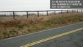
The actual location was right on the fence line. Success! @38.8008,-77.0039


Achievements
OfficeLinebacker earned the Multihash Achievement
|
OfficeLinebacker earned the Tron achievement
|
OfficeLinebacker earned the Land geohash achievement
|