Difference between revisions of "2013-03-22 43 -116"
imported>Eldin ([live picture] Hash is just over that hill. [http://www.openstreetmap.org/?lat=43.55610000&lon=-116.13700000&zoom=16&layers=B000FTF @43.5561,-116.1370]) |
imported>FippeBot m (Location) |
||
| (3 intermediate revisions by one other user not shown) | |||
| Line 1: | Line 1: | ||
| − | |||
| − | |||
| − | |||
| − | |||
| − | |||
| − | |||
| − | |||
| − | |||
| − | |||
| − | |||
{{meetup graticule | {{meetup graticule | ||
| lat=43 | | lat=43 | ||
| Line 15: | Line 5: | ||
}} | }} | ||
| − | |||
__NOTOC__ | __NOTOC__ | ||
== Location == | == Location == | ||
| − | + | In the hills near Lucky Peak Reservoir. | |
== Participants == | == Participants == | ||
| − | + | *[[User:Eldin | Eldin]] | |
| − | + | *Pojana | |
| − | |||
| − | |||
| − | |||
== Expedition == | == Expedition == | ||
| − | + | Pojana and I set out for the hash at about 6pm, after I got off work. We drove to a parking lot a bit over a mile away from the hash, and set out on foot from there. There were a few promising looking trails at the beginning, but they quickly vanished or turned away from the hash. After about a quarter of a mile of climbing the hill and making our way through the sagebrush, Pojana decided to turn back. I kept going. But at about 1/3 of a mile from the hash, the steepness of the hill increased significantly. | |
| + | At this point, cold, tired, and a little worried about my wife waiting down by the car, I gave up. Had I been alone, I would have tried to go further. Had the weather been warmer, I would have tried to go further. Had both of those things been true, I might have even found it within myself to make it all the way to the hash. But as it was, the expedition ended in failure. | ||
*Thwarted by terrain steeper than it looked online. -- [[User:Eldin|Eldin]] ([[User talk:Eldin|talk]]) [http://www.openstreetmap.org/?lat=43.51594362&lon=-116.04515490&zoom=16&layers=B000FTF @43.5159,-116.0452] 19:20, 22 March 2013 (MDT) | *Thwarted by terrain steeper than it looked online. -- [[User:Eldin|Eldin]] ([[User talk:Eldin|talk]]) [http://www.openstreetmap.org/?lat=43.51594362&lon=-116.04515490&zoom=16&layers=B000FTF @43.5159,-116.0452] 19:20, 22 March 2013 (MDT) | ||
| − | |||
| − | |||
== Photos == | == Photos == | ||
| − | |||
| − | |||
| − | |||
<gallery perrow="5"> | <gallery perrow="5"> | ||
Image:2013-03-22_43_-116_19-22-56-696.jpg | Hash is just over that hill. [http://www.openstreetmap.org/?lat=43.55610000&lon=-116.13700000&zoom=16&layers=B000FTF @43.5561,-116.1370] | Image:2013-03-22_43_-116_19-22-56-696.jpg | Hash is just over that hill. [http://www.openstreetmap.org/?lat=43.55610000&lon=-116.13700000&zoom=16&layers=B000FTF @43.5561,-116.1370] | ||
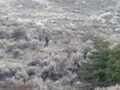
| + | File:2013-03-22 43 -116 grins.jpg | Tired, but still smiling. | ||
| + | File:2013-03-22 43 -116 view.jpg | This lovely view was the main reward for today's expedition. | ||
| + | File:2013-03-22 43 -116 return.jpg | My not-so-triumphant return down the mountain. | ||
</gallery> | </gallery> | ||
| − | |||
| − | |||
| − | |||
| − | |||
| − | |||
| − | |||
| − | |||
| − | |||
| − | |||
| − | |||
| − | |||
| − | |||
| − | |||
| − | |||
[[Category:Expeditions]] | [[Category:Expeditions]] | ||
| − | |||
[[Category:Expeditions with photos]] | [[Category:Expeditions with photos]] | ||
| − | |||
| − | |||
| − | |||
| − | |||
| − | |||
| − | |||
| − | |||
| − | |||
| − | |||
[[Category:Coordinates not reached]] | [[Category:Coordinates not reached]] | ||
| − | |||
| − | |||
[[Category:Not reached - Mother Nature]] | [[Category:Not reached - Mother Nature]] | ||
| − | + | {{location|US|ID|AA}} | |
| − | |||
| − | |||
| − | |||
| − | |||
| − | |||
| − | |||
| − | |||
| − | |||
| − | |||
| − | |||
Latest revision as of 01:29, 14 August 2019
| Fri 22 Mar 2013 in 43,-116: 43.5108590, -116.0339886 geohashing.info google osm bing/os kml crox |
Location
In the hills near Lucky Peak Reservoir.
Participants
- Eldin
- Pojana
Expedition
Pojana and I set out for the hash at about 6pm, after I got off work. We drove to a parking lot a bit over a mile away from the hash, and set out on foot from there. There were a few promising looking trails at the beginning, but they quickly vanished or turned away from the hash. After about a quarter of a mile of climbing the hill and making our way through the sagebrush, Pojana decided to turn back. I kept going. But at about 1/3 of a mile from the hash, the steepness of the hill increased significantly.
At this point, cold, tired, and a little worried about my wife waiting down by the car, I gave up. Had I been alone, I would have tried to go further. Had the weather been warmer, I would have tried to go further. Had both of those things been true, I might have even found it within myself to make it all the way to the hash. But as it was, the expedition ended in failure.
- Thwarted by terrain steeper than it looked online. -- Eldin (talk) @43.5159,-116.0452 19:20, 22 March 2013 (MDT)
Photos
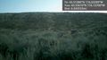
Hash is just over that hill. @43.5561,-116.1370

Tired, but still smiling.
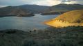
This lovely view was the main reward for today's expedition.
My not-so-triumphant return down the mountain.


