Difference between revisions of "2013-03-26 50 8"
From Geohashing
imported>Yakamoz (→Achievements) |
imported>FippeBot m (Location) |
||
| (One intermediate revision by one other user not shown) | |||
| Line 42: | Line 42: | ||
| latitude = 50 | | latitude = 50 | ||
| longitude = 8 | | longitude = 8 | ||
| − | | date = | + | | date = 2013-03-26 |
| name = Yakamoz | | name = Yakamoz | ||
| distance = 3 km | | distance = 3 km | ||
| Line 52: | Line 52: | ||
[[Category:Expeditions with photos]] | [[Category:Expeditions with photos]] | ||
[[Category:Coordinates reached]] | [[Category:Coordinates reached]] | ||
| + | {{location|DE|HE|GI}} | ||
Latest revision as of 01:35, 14 August 2019
| Tue 26 Mar 2013 in 50,8: 50.5946699, 8.6841293 geohashing.info google osm bing/os kml crox |
Location
on the Theodor Litt school yard in Ringallee (Gießen)
Participants
Plans
My first plan was to combine geohashing with swimming because this geohash point was in the same street (Ringallee) as my favourite baths in Gießen where I learned swimming. A letter from the Foreign Office changed my intention: foreign department first and then geohashing.
Expedition
Coordinates reached!
Photos
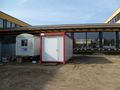
Geohash_point
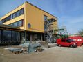
Theodor Litt School and its almost completed construction


Achievements
Yakamoz earned the Land geohash achievement
|
Yakamoz earned the Bicycle geohash achievement
|