Difference between revisions of "2013-04-04 -35 149"
imported>1PE (Created page with "lat = -35 |lon = 149 |date = 2013-04-04") |
imported>FippeBot m (Location) |
||
| (4 intermediate revisions by one other user not shown) | |||
| Line 1: | Line 1: | ||
| − | [[ | + | |
| + | <!-- If you did not specify these parameters in the template, please substitute appropriate values for IMAGE, LAT, LON, and DATE (YYYY-MM-DD format) | ||
| + | |||
| + | [[Image:{{{image|IMAGE}}}|thumb|left]] | ||
| + | |||
| + | Remove this section if you don't want an image at the top (left) of your report. You should remove the "Image:" or "File:" | ||
| + | tag from your image file name, and replace the all upper-case word IMAGE in the above line. | ||
| + | |||
| + | And DON'T FORGET to add your expedition and the best photo you took to the gallery on the Main Page! We'd love to read your report, but that means we first have to discover it! :) | ||
| + | --> | ||
| + | {{meetup graticule | ||
| + | | lat=-35 | ||
| + | | lon=149 | ||
| + | | date=2013-04-04 | ||
| + | }} | ||
| + | |||
| + | <!-- edit as necessary --> | ||
| + | __NOTOC__ | ||
| + | == Location == | ||
| + | In a field near the Bicentennial National Trail, at Coolamon Ridge (Canberra Nature Park). | ||
| + | |||
| + | == Participants == | ||
| + | * [[User:1PE|1PE]] | ||
| + | |||
| + | == Plans == | ||
| + | ===[[User:1PE|1PE]]=== | ||
| + | Lunchtime jaunt from work, and get some fresh air and exercise. | ||
| + | |||
| + | == Expedition == | ||
| + | ===[[User:1PE|1PE]]=== | ||
| + | Rather than taking the Bicentennial National Trail (our local part of a horse trail that extends several thousand kilometers) I went up the steep hill. Hmmmm.... bad move! Several barbed-sire fences later and I was still circling in on the GPS position. Finally, another fence and I was in the field. As close as I could tell, it was near an old, concrete fence post. So, I took a picture or two, and traced uphill along the line of the two existing posts and saw no more sign of the old fence. Pics as I reached the northern side of the hill. | ||
| + | |||
| + | == Photos == | ||
| + | <!-- Insert pictures between the gallery tags using the following format: | ||
| + | Image:2012-##-## ## ## Alpha.jpg | Witty Comment | ||
| + | --> | ||
| + | <gallery perrow="5"> | ||
| + | image:2013-04-04_-35_149_post-farm.jpg|Me and my concrete fence post. Farm house in background. | ||
| + | image:2013-04-04_-35_149_BM.jpg|View of Canberra suburbs and city landmarks (eg the iconic Telstra Tower) | ||
| + | image:2013-04-04_-35_149_Coolamon.jpg|Where I was..... | ||
| + | </gallery> | ||
| + | |||
| + | == Achievements == | ||
| + | {{#vardefine:ribbonwidth|800px}} | ||
| + | <!-- Add any achievement ribbons you earned below, or remove this section --> | ||
| + | |||
| + | |||
| + | [[Category:Expeditions]] | ||
| + | [[Category:Expeditions with photos]] | ||
| + | [[Category:Coordinates reached]] | ||
| + | {{location|AU|ACT}} | ||
Latest revision as of 01:44, 14 August 2019
| Thu 4 Apr 2013 in -35,149: -35.3535561, 149.0227256 geohashing.info google osm bing/os kml crox |
Location
In a field near the Bicentennial National Trail, at Coolamon Ridge (Canberra Nature Park).
Participants
Plans
1PE
Lunchtime jaunt from work, and get some fresh air and exercise.
Expedition
1PE
Rather than taking the Bicentennial National Trail (our local part of a horse trail that extends several thousand kilometers) I went up the steep hill. Hmmmm.... bad move! Several barbed-sire fences later and I was still circling in on the GPS position. Finally, another fence and I was in the field. As close as I could tell, it was near an old, concrete fence post. So, I took a picture or two, and traced uphill along the line of the two existing posts and saw no more sign of the old fence. Pics as I reached the northern side of the hill.
Photos
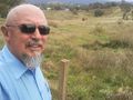
Me and my concrete fence post. Farm house in background.
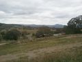
View of Canberra suburbs and city landmarks (eg the iconic Telstra Tower)
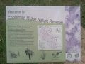
Where I was.....


