Difference between revisions of "2013-04-04 -35 149"
imported>1PE |
imported>FippeBot m (Location) |
||
| (3 intermediate revisions by one other user not shown) | |||
| Line 18: | Line 18: | ||
__NOTOC__ | __NOTOC__ | ||
== Location == | == Location == | ||
| − | + | In a field near the Bicentennial National Trail, at Coolamon Ridge (Canberra Nature Park). | |
== Participants == | == Participants == | ||
| − | + | * [[User:1PE|1PE]] | |
| − | |||
== Plans == | == Plans == | ||
| − | + | ===[[User:1PE|1PE]]=== | |
| + | Lunchtime jaunt from work, and get some fresh air and exercise. | ||
== Expedition == | == Expedition == | ||
| − | + | ===[[User:1PE|1PE]]=== | |
| − | + | Rather than taking the Bicentennial National Trail (our local part of a horse trail that extends several thousand kilometers) I went up the steep hill. Hmmmm.... bad move! Several barbed-sire fences later and I was still circling in on the GPS position. Finally, another fence and I was in the field. As close as I could tell, it was near an old, concrete fence post. So, I took a picture or two, and traced uphill along the line of the two existing posts and saw no more sign of the old fence. Pics as I reached the northern side of the hill. | |
| − | == | ||
| − | |||
== Photos == | == Photos == | ||
| Line 38: | Line 36: | ||
--> | --> | ||
<gallery perrow="5"> | <gallery perrow="5"> | ||
| + | image:2013-04-04_-35_149_post-farm.jpg|Me and my concrete fence post. Farm house in background. | ||
| + | image:2013-04-04_-35_149_BM.jpg|View of Canberra suburbs and city landmarks (eg the iconic Telstra Tower) | ||
| + | image:2013-04-04_-35_149_Coolamon.jpg|Where I was..... | ||
</gallery> | </gallery> | ||
| Line 45: | Line 46: | ||
| − | |||
| − | |||
| − | |||
| − | |||
| − | |||
| − | |||
| − | |||
| − | |||
| − | |||
| − | |||
[[Category:Expeditions]] | [[Category:Expeditions]] | ||
| − | + | [[Category:Expeditions with photos]] | |
| − | [[Category:Expeditions with photos]] | ||
| − | |||
| − | |||
| − | |||
| − | |||
| − | |||
[[Category:Coordinates reached]] | [[Category:Coordinates reached]] | ||
| − | + | {{location|AU|ACT}} | |
| − | |||
| − | |||
| − | |||
| − | |||
| − | |||
| − | |||
| − | |||
| − | |||
| − | |||
| − | |||
| − | |||
| − | |||
| − | |||
| − | |||
| − | |||
| − | |||
| − | |||
Latest revision as of 01:44, 14 August 2019
| Thu 4 Apr 2013 in -35,149: -35.3535561, 149.0227256 geohashing.info google osm bing/os kml crox |
Location
In a field near the Bicentennial National Trail, at Coolamon Ridge (Canberra Nature Park).
Participants
Plans
1PE
Lunchtime jaunt from work, and get some fresh air and exercise.
Expedition
1PE
Rather than taking the Bicentennial National Trail (our local part of a horse trail that extends several thousand kilometers) I went up the steep hill. Hmmmm.... bad move! Several barbed-sire fences later and I was still circling in on the GPS position. Finally, another fence and I was in the field. As close as I could tell, it was near an old, concrete fence post. So, I took a picture or two, and traced uphill along the line of the two existing posts and saw no more sign of the old fence. Pics as I reached the northern side of the hill.
Photos
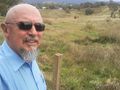
Me and my concrete fence post. Farm house in background.
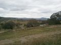
View of Canberra suburbs and city landmarks (eg the iconic Telstra Tower)
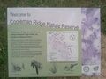
Where I was.....


