Difference between revisions of "2013-04-20 43 -116"
imported>Eldin (Fill in expedition details.) |
imported>FippeBot m (Location) |
||
| (2 intermediate revisions by 2 users not shown) | |||
| Line 1: | Line 1: | ||
| − | + | [[Image:2013-04-20_43_-116_14-52-27-843.jpg|thumb|left]] | |
| − | [[Image: | ||
| − | |||
{{meetup graticule | {{meetup graticule | ||
| lat=43 | | lat=43 | ||
| Line 13: | Line 11: | ||
== Participants == | == Participants == | ||
| − | * [[User:Eldin|Eldin]] | + | * [[User:Eldin |Eldin ]] |
== Plans == | == Plans == | ||
| Line 27: | Line 25: | ||
== Photos == | == Photos == | ||
| − | + | ||
| − | |||
| − | |||
<gallery perrow="5"> | <gallery perrow="5"> | ||
Image:2013-04-20_43_-116_14-49-43-792.jpg | The hash point. | Image:2013-04-20_43_-116_14-49-43-792.jpg | The hash point. | ||
| − | |||
Image:2013-04-20_43_-116_14-50-19-536.jpg | The bicycle. | Image:2013-04-20_43_-116_14-50-19-536.jpg | The bicycle. | ||
| − | |||
Image:2013-04-20_43_-116_14-50-50-001.jpg | The grin. | Image:2013-04-20_43_-116_14-50-50-001.jpg | The grin. | ||
| − | |||
Image:2013-04-20_43_-116_14-52-27-843.jpg | Building under construction beside hash point. | Image:2013-04-20_43_-116_14-52-27-843.jpg | Building under construction beside hash point. | ||
| − | + | Image:2013-04-20_43_-116_14-54-05-091.jpg | Decorative water feature beside hash point. | |
| − | Image:2013-04-20_43_-116_14-54-05-091.jpg | Decorative water feature beside hash | ||
| − | |||
File:2013-04-20 43 -116 proof.jpg | Proof | File:2013-04-20 43 -116 proof.jpg | Proof | ||
</gallery> | </gallery> | ||
| Line 47: | Line 38: | ||
== Achievements == | == Achievements == | ||
{{#vardefine:ribbonwidth|800px}} | {{#vardefine:ribbonwidth|800px}} | ||
| + | {{Land geohash | ||
| + | | latitude = 43 | ||
| + | | longitude = -116 | ||
| + | | date = 2013-04-20 | ||
| + | | name = [[User:Eldin |Eldin ]] | ||
| + | }} | ||
{{bicycle geohash | {{bicycle geohash | ||
| latitude = 43 | | latitude = 43 | ||
| longitude = -116 | | longitude = -116 | ||
| date = 2013-04-20 | | date = 2013-04-20 | ||
| − | | name = [[User:Eldin|Eldin]] | + | | name = [[User:Eldin |Eldin ]] |
| distance = 10.5 miles | | distance = 10.5 miles | ||
| bothways = true | | bothways = true | ||
| Line 60: | Line 57: | ||
[[Category:Expeditions with photos]] | [[Category:Expeditions with photos]] | ||
[[Category:Coordinates reached]] | [[Category:Coordinates reached]] | ||
| + | {{location|US|ID|AA}} | ||
Latest revision as of 01:57, 14 August 2019

| Sat 20 Apr 2013 in 43,-116: 43.6109672, -116.3558785 geohashing.info google osm bing/os kml crox |
Location
On the front drive of the new headquarters for Scentsy, which is under construction.
Participants
Plans
To ride my bicycle to the hash point, as showed the uncommon combination of being within reasonable bicycle distance, and looking to probably be reachable.
Expedition
Rode my bicycle to the coordinates. Parts of the ride were a bit nerve-wracking, as they were along busy, high-speed streets without bike lanes, but I arrived without incident. At the hash point I took some pictures. The place looks like it will be rather nice once they finish construction. After I finished, I rode a few more miles to check out tomorrow's hash point, and verified that it should be reachable. All in all, I rode a bit over 10 miles on today's expedition.
- Reached the coordinates for my 1st bicycle geohash! -- Eldin (talk) @43.6110,-116.3559 14:46, 20 April 2013 (MDT)
Tracklog
A tracklog was recorded. I'll link it if I ever post it online.
Photos
The hash point.
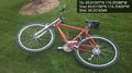
The bicycle.
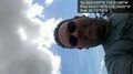
The grin.
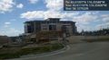
Building under construction beside hash point.
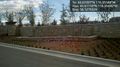
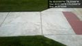
Decorative water feature beside hash point.
Proof


Achievements
Eldin earned the Land geohash achievement
|
Eldin earned the Bicycle geohash achievement
|