Difference between revisions of "2013-05-01 33 -116"
From Geohashing
imported>LucasBrown |
imported>FippeBot m (Location) |
||
| (One intermediate revision by one other user not shown) | |||
| Line 14: | Line 14: | ||
</gallery> | </gallery> | ||
| − | + | ||
| + | == Achievements == | ||
| + | |||
| + | * Land Geohash | ||
| + | |||
| + | |||
[[Category:Expeditions]] | [[Category:Expeditions]] | ||
[[Category:Expeditions with photos]] | [[Category:Expeditions with photos]] | ||
[[Category:Expedition without GPS]] | [[Category:Expedition without GPS]] | ||
[[Category:Coordinates reached]] | [[Category:Coordinates reached]] | ||
| + | {{location|US|CA|SD}} | ||
Latest revision as of 02:07, 14 August 2019
| Wed 1 May 2013 in 33,-116: 33.3082730, -116.6824313 geohashing.info google osm bing/os kml crox |
Location
Just north of the Warner Springs gliderport
Participants
Photos
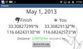
Geohash Droid details page at the hashpoint
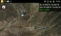
Map at the hashpoint


Achievements
- Land Geohash