Difference between revisions of "2013-05-17 44 -116"
imported>Eldin (An expedition message sent via Geohash Droid for Android.) |
m (per Renaming Proposal) |
||
| (5 intermediate revisions by 2 users not shown) | |||
| Line 1: | Line 1: | ||
| − | |||
| − | |||
| − | |||
| − | |||
| − | |||
| − | |||
| − | |||
| − | |||
| − | |||
| − | |||
{{meetup graticule | {{meetup graticule | ||
| lat=44 | | lat=44 | ||
| Line 15: | Line 5: | ||
}} | }} | ||
| − | |||
__NOTOC__ | __NOTOC__ | ||
== Location == | == Location == | ||
| − | + | In the hills northwest of Midvale, ID | |
== Participants == | == Participants == | ||
| − | + | * [[User:Eldin|Eldin]] | |
| − | |||
== Plans == | == Plans == | ||
| − | + | When I got off work early, and saw that this one was likely reachable, I decided to try for it. I've been wanting to hit a hash here since this graticule has already defeated me twice. | |
== Expedition == | == Expedition == | ||
| − | + | After getting home from work, I set out for the hashpoint. It was a pleasant drive up to the area of the hash, though I did pass through a significant rainstorm. I found a place to park about a mile from the hash, and set off walking. There was a fence, but it was in poor repair, so it was easy to cross. There were no signs prohibiting entry. The I walked about a mile to reach the hashpoint. I encountered a number of cows while in route, but they all ignored or avoided me. The rainstorm I drove through on my way had been here maybe an hour prior to my arrival, so the ground was a bit muddy. And the terrain was a bit steep in places (there was about 700ft of vertical rise between where I parked and the hash). There were quite a few stands of chokecherry trees in the area, which makes it odd that they were keeping cows there, since the leaves are poisonous. They won't really harm an adult cow, but they can kill calves, and cause significant birth defects or stillbirth if pregnant cows eat them. Eventually, I arrived at the coordinates. Tired and a bit out of breath, but thrilled to have finally reached a hash in this graticule. I took some pictures, posted about my success, and then headed back down to where I had parked. On the way back down I called my wife to to share my success, though she was predictably somewhat less excited by it than me. It was a fun expedition, and a good workout. And very exciting to finally have success in this graticule which has proven a challenge in the past. | |
| + | |||
| + | |||
| + | *Another cherry popped! Full report later -- [[User:Eldin|Eldin]] ([[User talk:Eldin|talk]]) [http://www.openstreetmap.org/?lat=44.50836990&lon=-116.80281840&zoom=16&layers=B000FTF @44.5084,-116.8028] 19:13, 17 May 2013 (MDT) | ||
| − | |||
| − | |||
== Photos == | == Photos == | ||
| − | |||
| − | |||
| − | |||
<gallery perrow="5"> | <gallery perrow="5"> | ||
| + | File:2013-05-17 44 -116 proof.jpg | Proof of achievement. | ||
| + | File:2013-05-17 44 -116 grin.jpg | Silly (and somewhat winded) grin. | ||
| + | File:2013-05-17 44 -116 hashpoint.jpg | Sagebrush at the coordinates. | ||
| + | File:2013-05-17 44 -116chokecherries.jpg | Chokecherries! Unfortunately, too early in the year for them to be ripe. | ||
| + | File:2013-05-17 44 -116 view1.jpg | View looking back towards the road. You can see my car if you look closely. | ||
| + | File:2013-05-17 44 -116 view2.jpg | View back towards Midvale. | ||
</gallery> | </gallery> | ||
== Achievements == | == Achievements == | ||
{{#vardefine:ribbonwidth|800px}} | {{#vardefine:ribbonwidth|800px}} | ||
| − | + | {{Graticule unlocked | |
| + | | latitude = 44 | ||
| + | | longitude = -116| date = 2013-05-17 | ||
| + | | name = [[User:Eldin|Eldin]] | ||
| + | }} | ||
| + | {{Minesweeper geohash | ||
| + | | graticule = Boise, Idaho | ||
| + | | ranknumber = 3 | ||
| + | | n = true | ||
| + | | e = true | ||
| + | | se = true | ||
| + | | name = [[User:Eldin|Eldin]] | ||
| + | }} | ||
| + | {{land geohash | ||
| + | | latitude = 44 | ||
| + | | longitude = -116 | ||
| + | | date = 2013-05-17 | ||
| + | | name = [[User:Eldin|Eldin]] | ||
| + | }} | ||
| − | |||
| − | |||
| − | |||
| − | |||
| − | |||
| − | |||
| − | |||
| − | |||
| − | |||
| − | |||
| − | |||
[[Category:Expeditions]] | [[Category:Expeditions]] | ||
| − | |||
[[Category:Expeditions with photos]] | [[Category:Expeditions with photos]] | ||
| − | |||
| − | |||
| − | |||
| − | |||
| − | |||
[[Category:Coordinates reached]] | [[Category:Coordinates reached]] | ||
| − | + | {{location|US|ID|WA}} | |
| − | |||
| − | |||
| − | |||
| − | |||
| − | |||
| − | |||
| − | |||
| − | |||
| − | |||
| − | |||
| − | |||
| − | |||
| − | |||
| − | |||
| − | |||
| − | |||
| − | |||
Latest revision as of 05:25, 20 March 2024
| Fri 17 May 2013 in 44,-116: 44.5083489, -116.8027646 geohashing.info google osm bing/os kml crox |
Location
In the hills northwest of Midvale, ID
Participants
Plans
When I got off work early, and saw that this one was likely reachable, I decided to try for it. I've been wanting to hit a hash here since this graticule has already defeated me twice.
Expedition
After getting home from work, I set out for the hashpoint. It was a pleasant drive up to the area of the hash, though I did pass through a significant rainstorm. I found a place to park about a mile from the hash, and set off walking. There was a fence, but it was in poor repair, so it was easy to cross. There were no signs prohibiting entry. The I walked about a mile to reach the hashpoint. I encountered a number of cows while in route, but they all ignored or avoided me. The rainstorm I drove through on my way had been here maybe an hour prior to my arrival, so the ground was a bit muddy. And the terrain was a bit steep in places (there was about 700ft of vertical rise between where I parked and the hash). There were quite a few stands of chokecherry trees in the area, which makes it odd that they were keeping cows there, since the leaves are poisonous. They won't really harm an adult cow, but they can kill calves, and cause significant birth defects or stillbirth if pregnant cows eat them. Eventually, I arrived at the coordinates. Tired and a bit out of breath, but thrilled to have finally reached a hash in this graticule. I took some pictures, posted about my success, and then headed back down to where I had parked. On the way back down I called my wife to to share my success, though she was predictably somewhat less excited by it than me. It was a fun expedition, and a good workout. And very exciting to finally have success in this graticule which has proven a challenge in the past.
- Another cherry popped! Full report later -- Eldin (talk) @44.5084,-116.8028 19:13, 17 May 2013 (MDT)
Photos
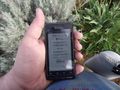
Proof of achievement.

Silly (and somewhat winded) grin.
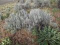
Sagebrush at the coordinates.
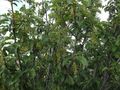
Chokecherries! Unfortunately, too early in the year for them to be ripe.
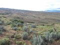
View looking back towards the road. You can see my car if you look closely.
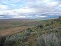
View back towards Midvale.


Achievements
Eldin earned the Graticule Unlocked Achievement
|
Eldin achieved level 3 of the Minesweeper Geohash achievement
|
Eldin earned the Land geohash achievement
|