Difference between revisions of "2013-05-25 49 8"
imported>Mampfred |
imported>FippeBot m (Location) |
||
| (14 intermediate revisions by 4 users not shown) | |||
| Line 7: | Line 7: | ||
__NOTOC__ | __NOTOC__ | ||
== Location == | == Location == | ||
| − | In the woods. | + | <strike>In the woods</strike> In a swamp-like forest area near Gernsheim next to the Autobahn A67. |
== Participants == | == Participants == | ||
| Line 13: | Line 13: | ||
* [[User:Rincewind|Rincewind]] | * [[User:Rincewind|Rincewind]] | ||
* [[User:Mampfred|Mampfred]] | * [[User:Mampfred|Mampfred]] | ||
| − | |||
| − | |||
| − | |||
| − | |||
| − | |||
== Plans == | == Plans == | ||
| Line 23: | Line 18: | ||
== Expedition == | == Expedition == | ||
| − | + | === Mampfred === | |
| + | Parked north of the hash just coming off the A67, apparently it's something to do with [http://www.eon.de eon]. Had 25 minutes to reach the hash at 4pm. Also remembered to bring my towel, yay :D | ||
| + | |||
| + | Went across the street into the woods and walked peacefully for most of the way. No other hashers in sight and a pleasant hum from the Autobahn drowning out any noises from the woods. Shame that. | ||
| + | |||
| + | Anyway, got closer to the hash just to notice it's a swamp like area. The hash dance was particularly complicated as reception was rubbish and and one point it actually led me around a large pool of water just to bring me right back where I started. After recalibrating the compass though, I got the 0m screenshot quick enough. | ||
| + | |||
| + | While standing around (and talking on the phone, work never leaves you alone, ey?) I was wondering where the rest of the guys would be ... when the phone rang and Rincewind let me know that he lost reception and didn't really know where he was. We agreed that he'd keep trying and low and behold just a few minutes later I spotted not just one but two other hashers approaching ... | ||
| + | |||
| + | === Draradech === | ||
| + | Tried to drive near the hash from the south, but the paths were all off limits. Circled around and drove near the hash from the north. | ||
| + | |||
| + | The map had a way leading almost directly to the hash, but in reality I couldn't find the entry. After a short while through deep wood I found the way. | ||
| + | |||
| + | As I neared the hash Rincewind came on the same way towards me. 50m to the right Mampfred was waiting at the hashpoint. | ||
| + | |||
| + | === The Meeting === | ||
| + | |||
| + | When we finally were all together we fought off mosquitos, shared some cake and coffee for the picnic achievement (thanks Draradech!), took some group shots and Draradech even juggled for a bit to get his circus geohash achievement. All in all a lot of driving (in seperate cars all from the same general direction ... *cough*) for 2013 mouse over day. | ||
== Tracklog == | == Tracklog == | ||
| − | + | See [http://www.everytrail.com/view_trip.php?trip_id=2164930 here]. | |
== Photos == | == Photos == | ||
| − | |||
| − | |||
| − | |||
<gallery perrow="5"> | <gallery perrow="5"> | ||
| + | Image:2013-05-25_49_8_arrival.jpg | Coordinates reached | ||
| + | Image:2013-05-25_49_8_group.jpg | Group photo | ||
| + | Image:2013-05-25_49_8_picnic.jpg | Picnic | ||
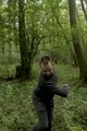
| + | Image:2013-05-25_49_8_juggle.jpg | Juggling | ||
| + | Image:2013-05-25_49_8_juggle_2.jpg | oops | ||
| + | Image:2013-05-25_49_8_coordinates_reached.jpg | Look at this geohash dance! | ||
</gallery> | </gallery> | ||
== Achievements == | == Achievements == | ||
{{#vardefine:ribbonwidth|800px}} | {{#vardefine:ribbonwidth|800px}} | ||
| − | |||
| − | |||
| − | |||
| − | |||
| − | |||
| − | |||
| − | [[ | + | {{Geohashing Day |
| + | | latitude = 49 | ||
| + | | longitude = 8 | ||
| + | | year = 2013 | ||
| + | | coorddate = 2013-05-25 | ||
| + | | mouseover = true | ||
| + | | name = Draradech, Rincewind and Mampfred | ||
| + | }} | ||
| + | {{Picnic geohash | ||
| + | | latitude = 49 | ||
| + | | longitude = 8 | ||
| + | | date = 2013-05-25 | ||
| + | | mouseover = true | ||
| + | | image = 2013-05-25_49_8_picnic.jpg | ||
| + | | name = Draradech, Rincewind and Mampfred | ||
| + | }} | ||
| + | {{Ribbon | ||
| + | | latitude = 49 | ||
| + | | longitude = 8 | ||
| + | | date = 2013-05-25 | ||
| + | | user = Mampfred | ||
| + | | icon = Landgeohash.png | ||
| + | | color = lightgreen | ||
| + | | achievement = honorary [[Towel Day achievment]] (since it's not been approved yet) | ||
| + | | action = bringing a towel to the hash on towel day | ||
| + | }} | ||
| + | {{Circus_geohash | ||
| + | | latitude = 49 | ||
| + | | longitude = 8 | ||
| + | | date = 2013-05-25 | ||
| + | | name = Draradech | ||
| + | | image = 2013-05-25_49_8_juggle.jpg | ||
| + | }} | ||
| − | |||
[[Category:Expeditions]] | [[Category:Expeditions]] | ||
| − | |||
[[Category:Expeditions with photos]] | [[Category:Expeditions with photos]] | ||
| − | |||
| − | |||
| − | |||
| − | |||
| − | |||
[[Category:Coordinates reached]] | [[Category:Coordinates reached]] | ||
| − | + | {{location|DE|HE|GG}} | |
| − | |||
| − | |||
| − | |||
| − | |||
| − | |||
| − | |||
| − | |||
| − | |||
| − | |||
| − | |||
| − | |||
| − | |||
| − | |||
| − | |||
| − | |||
| − | |||
| − | |||
Latest revision as of 02:33, 14 August 2019
| Sat 25 May 2013 in 49,8: 49.7289758, 8.5523316 geohashing.info google osm bing/os kml crox |
Location
In the woods In a swamp-like forest area near Gernsheim next to the Autobahn A67.
Participants
Plans
We'll have a 16:00 meetup to celebrate mouse over day.
Expedition
Mampfred
Parked north of the hash just coming off the A67, apparently it's something to do with eon. Had 25 minutes to reach the hash at 4pm. Also remembered to bring my towel, yay :D
Went across the street into the woods and walked peacefully for most of the way. No other hashers in sight and a pleasant hum from the Autobahn drowning out any noises from the woods. Shame that.
Anyway, got closer to the hash just to notice it's a swamp like area. The hash dance was particularly complicated as reception was rubbish and and one point it actually led me around a large pool of water just to bring me right back where I started. After recalibrating the compass though, I got the 0m screenshot quick enough.
While standing around (and talking on the phone, work never leaves you alone, ey?) I was wondering where the rest of the guys would be ... when the phone rang and Rincewind let me know that he lost reception and didn't really know where he was. We agreed that he'd keep trying and low and behold just a few minutes later I spotted not just one but two other hashers approaching ...
Draradech
Tried to drive near the hash from the south, but the paths were all off limits. Circled around and drove near the hash from the north.
The map had a way leading almost directly to the hash, but in reality I couldn't find the entry. After a short while through deep wood I found the way.
As I neared the hash Rincewind came on the same way towards me. 50m to the right Mampfred was waiting at the hashpoint.
The Meeting
When we finally were all together we fought off mosquitos, shared some cake and coffee for the picnic achievement (thanks Draradech!), took some group shots and Draradech even juggled for a bit to get his circus geohash achievement. All in all a lot of driving (in seperate cars all from the same general direction ... *cough*) for 2013 mouse over day.
Tracklog
See here.
Photos
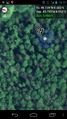
Coordinates reached
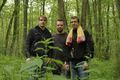
Group photo
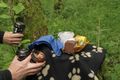
Picnic

Juggling
oops
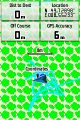
Look at this geohash dance!


Achievements
Draradech, Rincewind and Mampfred earned the 2013 Mouse Over Day achievement
|
Draradech, Rincewind and Mampfred earned the Picnic achievement
|
Mampfred earned the honorary Towel Day achievment (since it's not been approved yet)
|
Draradech earned the Circus Geohash Achievement
|