Difference between revisions of "2013-06-07 50 8"
From Geohashing
imported>Palmpje m (Typo) |
imported>FippeBot m (Location) |
||
| (4 intermediate revisions by 2 users not shown) | |||
| Line 7: | Line 7: | ||
__NOTOC__ | __NOTOC__ | ||
== Location == | == Location == | ||
| − | In the woods not far from | + | In the woods not far from Schlangenbad near Wiesbaden. |
== Participants == | == Participants == | ||
| Line 15: | Line 15: | ||
* [[User:LadyBB|LadyBB]] | * [[User:LadyBB|LadyBB]] | ||
* [[User:EmmJay|EmmJay]] | * [[User:EmmJay|EmmJay]] | ||
| − | * | + | * A dragalong |
| − | |||
| − | |||
== Plans == | == Plans == | ||
It's not too far away and QuarterCacher is still in his consecutive roll so we'll attempt this one in the afternoon. ETA ~ 5:30pm. | It's not too far away and QuarterCacher is still in his consecutive roll so we'll attempt this one in the afternoon. ETA ~ 5:30pm. | ||
| − | |||
== Expedition == | == Expedition == | ||
| − | + | We met up at the parking lot of a swimming pool not far from the hash. The rest was walking up steep hills and hash dancing. Pretty straight forward, easy hash. Number six for QuarterCachers consecutive run. | |
== Tracklog == | == Tracklog == | ||
| − | + | See [http://www.everytrail.com/view_trip.php?trip_id=2166545 here]. | |
== Photos == | == Photos == | ||
| − | |||
| − | |||
| − | |||
<gallery perrow="5"> | <gallery perrow="5"> | ||
| + | Image:2013-06-07_50_8_18-00-44-179.jpg | Coordinates reached | ||
</gallery> | </gallery> | ||
== Achievements == | == Achievements == | ||
{{#vardefine:ribbonwidth|800px}} | {{#vardefine:ribbonwidth|800px}} | ||
| − | + | {{Consecutive_geohash | |
| − | + | | latitude = 49 | |
| − | + | | longitude = 8 | |
| + | | count = 6 | ||
| + | | date = 2013-06-02 | ||
| + | | name = QuarterCacher | ||
| + | }} | ||
| − | |||
[[Category:Expeditions]] | [[Category:Expeditions]] | ||
| − | |||
[[Category:Expeditions with photos]] | [[Category:Expeditions with photos]] | ||
| − | |||
| − | |||
| − | |||
| − | |||
| − | |||
[[Category:Coordinates reached]] | [[Category:Coordinates reached]] | ||
| − | + | {{location|DE|HE|SWA}} | |
| − | |||
| − | |||
| − | |||
| − | |||
| − | |||
| − | |||
| − | |||
| − | |||
| − | |||
| − | |||
| − | |||
| − | |||
| − | |||
| − | |||
| − | |||
| − | |||
| − | |||
Latest revision as of 02:44, 14 August 2019
| Fri 7 Jun 2013 in 50,8: 50.0888188, 8.0962737 geohashing.info google osm bing/os kml crox |
Location
In the woods not far from Schlangenbad near Wiesbaden.
Participants
- QuarterCacher
- M
- Mampfred
- LadyBB
- EmmJay
- A dragalong
Plans
It's not too far away and QuarterCacher is still in his consecutive roll so we'll attempt this one in the afternoon. ETA ~ 5:30pm.
Expedition
We met up at the parking lot of a swimming pool not far from the hash. The rest was walking up steep hills and hash dancing. Pretty straight forward, easy hash. Number six for QuarterCachers consecutive run.
Tracklog
See here.
Photos
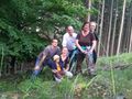
Coordinates reached

Achievements
QuarterCacher earned the Consecutive geohash achievement
|