Difference between revisions of "2013-06-11 53 -1"
From Geohashing
imported>Mampfred (Created page with "{{subst:Expedition |lat = 53 |lon = -1 |date = 2013-06-11 }}") |
imported>FippeBot m (Location) |
||
| (10 intermediate revisions by one other user not shown) | |||
| Line 1: | Line 1: | ||
| − | |||
| − | |||
| − | |||
| − | |||
| − | |||
| − | |||
| − | |||
| − | |||
| − | |||
| − | |||
{{meetup graticule | {{meetup graticule | ||
| lat=53 | | lat=53 | ||
| Line 15: | Line 5: | ||
}} | }} | ||
| − | |||
__NOTOC__ | __NOTOC__ | ||
== Location == | == Location == | ||
| − | + | Next to a street on grassland not far from Leeds. | |
== Participants == | == Participants == | ||
| − | + | * [[User:Mampfred|Mampfred]] | |
| − | + | * A dragalong | |
== Plans == | == Plans == | ||
| − | + | Mampfred will be driving through and hopefully (if timing is right and the colleague in the car is game) will make a quick stopover here. | |
== Expedition == | == Expedition == | ||
| − | + | Yay, everything worked out perfect. Picked up the car in the morning and convinced my colleague that it's a great idea to walk into a wet field in the middle of the UK before lunch. We jumped a little fence and found the hash to be five meters in. Took some photos and moved on to Doncaster to get some real work done ... | |
| − | |||
| − | |||
| − | |||
== Photos == | == Photos == | ||
| − | |||
| − | |||
| − | |||
<gallery perrow="5"> | <gallery perrow="5"> | ||
| + | Image:2013-06-11_53_-1_coordinates_reached.jpg | Coordinates reached | ||
| + | Image:2013-06-11_53_-1_13-25-41-245.jpg | Sign right next to the hash | ||
| + | Image:2013-06-11_53_-1_13-27-03-624.jpg | Street next to the hash | ||
| + | Image:2013-06-11_53_-1_13-27-38-761.jpg | View from the hash away from the street | ||
| + | Image:2013-06-11_53_-1_13-24-43-426.jpg | Happy hashers in a foreign country | ||
</gallery> | </gallery> | ||
== Achievements == | == Achievements == | ||
{{#vardefine:ribbonwidth|800px}} | {{#vardefine:ribbonwidth|800px}} | ||
| − | + | {{Radio Yerevan | |
| + | | latitude = 53 | ||
| + | | longitude = -1 | ||
| + | | date = 2013-06-11 | ||
| + | | name = Mampfred and a dragalong | ||
| + | | achievement = Border geohash achievement by crossing the Germany-UK border | ||
| + | | detail = they didn't cross the border "for the express purpose of attending a geohash" as pointed out on the talk page | ||
| + | }} | ||
| + | {{drag-along | ||
| + | | latitude=53 | ||
| + | | longitude=-1 | ||
| + | | date=2013-06-11 | ||
| + | | name=Mampfred | ||
| + | | partner=a colleague | ||
| + | }} | ||
| − | |||
| − | |||
| − | |||
| − | |||
| − | |||
| − | |||
| − | |||
| − | |||
| − | |||
| − | |||
| − | |||
[[Category:Expeditions]] | [[Category:Expeditions]] | ||
| − | |||
[[Category:Expeditions with photos]] | [[Category:Expeditions with photos]] | ||
| − | |||
| − | |||
| − | |||
| − | |||
| − | |||
[[Category:Coordinates reached]] | [[Category:Coordinates reached]] | ||
| − | + | {{location|GB|ENG|LDS}} | |
| − | |||
| − | |||
| − | |||
| − | |||
| − | |||
| − | |||
| − | |||
| − | |||
| − | |||
| − | |||
| − | |||
| − | |||
| − | |||
| − | |||
| − | |||
| − | |||
| − | |||
Latest revision as of 06:06, 6 August 2019
| Tue 11 Jun 2013 in 53,-1: 53.7469745, -1.6535536 geohashing.info google osm bing/os kml crox |
Location
Next to a street on grassland not far from Leeds.
Participants
- Mampfred
- A dragalong
Plans
Mampfred will be driving through and hopefully (if timing is right and the colleague in the car is game) will make a quick stopover here.
Expedition
Yay, everything worked out perfect. Picked up the car in the morning and convinced my colleague that it's a great idea to walk into a wet field in the middle of the UK before lunch. We jumped a little fence and found the hash to be five meters in. Took some photos and moved on to Doncaster to get some real work done ...
Photos
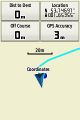
Coordinates reached
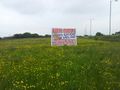
Sign right next to the hash
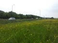
Street next to the hash
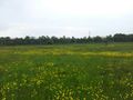
View from the hash away from the street
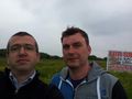
Happy hashers in a foreign country


Achievements
Is it true that this user earned the Border geohash achievement by crossing the Germany-UK border?
|
Mampfred earned the Drag-along achievement
|