Difference between revisions of "2008-05-23 52 4"
From Geohashing
imported>Ath |
imported>FippeBot m (Location) |
||
| (One intermediate revision by one other user not shown) | |||
| Line 1: | Line 1: | ||
| + | {{pre30w}} | ||
{{meetup graticule | {{meetup graticule | ||
| map=<map lat="52" lon="4" date="2008-05-23" /> | | map=<map lat="52" lon="4" date="2008-05-23" /> | ||
| Line 17: | Line 18: | ||
[[Category:Expeditions with photos]] | [[Category:Expeditions with photos]] | ||
[[Category:Coordinates reached]] | [[Category:Coordinates reached]] | ||
| + | {{location|NL|NH}} | ||
Latest revision as of 04:02, 7 August 2019
Note: This expedition used an old version of the Geohashing algorithm before the 30W Time Zone Rule was enacted.
| Fri 23 May 2008 in 52,4: 52.4002469, 4.7227719 geohashing.info google osm bing/os kml crox |
Friday afternoon after work, the geohashing location of graticule (52,4) was reached by Niels. Just because it was a 5 minute drive from his home. The location was at Houtrak, inbetween Amsterdam and Spaarnwoude, in a field right outside the Houtrak golfcourse.
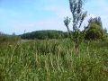
Hard to reach in the middle of a field
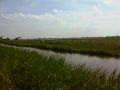
View on the location from a near dike.
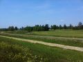
The other side of the dike showed the Houtrak golfcourse


