Difference between revisions of "2013-07-13 39 -77"
From Geohashing
imported>Calamus m (Categorizing) |
imported>FippeBot m (Location) |
||
| Line 71: | Line 71: | ||
[[Category:Expeditions with photos]] | [[Category:Expeditions with photos]] | ||
[[Category:Coordinates reached]] | [[Category:Coordinates reached]] | ||
| + | {{location|US|MD|WA}} | ||
Latest revision as of 06:11, 6 August 2019
| Sat 13 Jul 2013 in 39,-77: 39.6464569, -77.6879201 geohashing.info google osm bing/os kml crox |
Location
On the banks of the Antietam River
Participants
Plans
Expedition
- On our way! -- OfficeLinebacker (talk) @39.0859,-77.1706 17:11, 13 July 2013 (EDT)
Tracklog
Photos
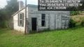
Abandoned structure @39.6476,-77.6878
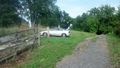
The car that brought us here
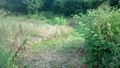
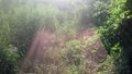
The path and view down to the hashpoint


Allison walking near the hash

The vegetation is lush.
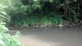
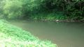
The moss covered banks of Antietam Creek

Silly us at the spot @39.6464,-77.6879


