Difference between revisions of "2013-07-15 51 7"
From Geohashing
imported>GeorgDerReisende (Created page with "{{subst:Expedition |lat = 51 |lon = 7 |date = 2013-07-15 }}") |
imported>FippeBot m (Location) |
||
| (5 intermediate revisions by one other user not shown) | |||
| Line 1: | Line 1: | ||
| − | |||
| − | |||
| − | |||
| − | |||
| − | |||
| − | |||
| − | |||
| − | |||
| − | |||
| − | |||
{{meetup graticule | {{meetup graticule | ||
| lat=51 | | lat=51 | ||
| Line 18: | Line 8: | ||
__NOTOC__ | __NOTOC__ | ||
== Location == | == Location == | ||
| − | + | ||
| + | The hash lies near the motorway interchange Kamener Kreuz. | ||
== Participants == | == Participants == | ||
| − | + | ||
| − | + | [[User:GeorgDerReisende|GeorgDerReisende]] | |
== Plans == | == Plans == | ||
| − | + | ||
| + | I want to come from [[2013-07-15 51 8]] by hitchhiking. Because of the type of the location I need some kilometers to walk, maybe I can take a bus. Afterwards I want to go to [[2013-07-15 50 8]], also by hitchhiking. | ||
== Expedition == | == Expedition == | ||
| − | + | ||
| + | After successfully managed the [[2013-07-15 51 8]], I travelled to this hash. I changed the car at the service station ''Am Haarstrang'' and got a car up to the junction ''Unna Ost'' at 13:45. From there I walked through Unna to the hash, where I arrived at 16:15. | ||
== Tracklog == | == Tracklog == | ||
| − | + | ||
== Photos == | == Photos == | ||
| − | |||
| − | |||
| − | |||
<gallery perrow="5"> | <gallery perrow="5"> | ||
| + | Image:2013-07-15 51 7 GeorgDerReisende 6565.jpg | the way to the hash | ||
| + | Image:2013-07-15 51 7 GeorgDerReisende 6567.jpg | somewhere near the hash | ||
| + | Image:2013-07-15 51 7 GeorgDerReisende 6570.jpg | view to the north from the hash | ||
| + | Image:2013-07-15 51 7 GeorgDerReisende 6571.jpg | view to the west, where I came from | ||
| + | Image:2013-07-15 51 7 GeorgDerReisende 6572.jpg | view to the south from the hash | ||
| + | Image:2013-07-15 51 7 GeorgDerReisende 6574.jpg | view to the east from the hash | ||
| + | Image:2013-07-15 51 7 GeorgDerReisende 6577.jpg | not really the hash, only some meters away | ||
</gallery> | </gallery> | ||
== Achievements == | == Achievements == | ||
{{#vardefine:ribbonwidth|800px}} | {{#vardefine:ribbonwidth|800px}} | ||
| − | |||
| + | {{Minesweeper geohash | graticule = Paderborn, Germany | ranknumber = 2 | w = true | ne = true | name = GeorgDerReisende }} | ||
| − | + | {{Multihash | |
| − | |||
| − | |||
| − | + | | latitude1 = 51 | |
| − | + | | longitude1 = 8 | |
| − | + | | latitude2 = 51 | |
| − | + | | longitude2 = 7 | |
| + | | date = 2013-07-15 | ||
| + | | name = GeorgDerReisende | ||
| + | |||
| + | }} | ||
| − | |||
[[Category:Expeditions]] | [[Category:Expeditions]] | ||
| − | + | ||
[[Category:Expeditions with photos]] | [[Category:Expeditions with photos]] | ||
| − | + | ||
| − | |||
| − | |||
| − | |||
| − | |||
[[Category:Coordinates reached]] | [[Category:Coordinates reached]] | ||
| − | + | {{location|DE|NW|UN}} | |
| − | |||
| − | |||
| − | |||
| − | |||
| − | |||
| − | |||
| − | |||
| − | |||
| − | |||
| − | |||
| − | |||
| − | |||
| − | |||
| − | |||
| − | |||
| − | |||
| − | |||
Latest revision as of 03:10, 14 August 2019
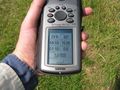
| Mon 15 Jul 2013 in 51,7: 51.5865881, 7.7034166 geohashing.info google osm bing/os kml crox |
Location
The hash lies near the motorway interchange Kamener Kreuz.
Participants
Plans
I want to come from 2013-07-15 51 8 by hitchhiking. Because of the type of the location I need some kilometers to walk, maybe I can take a bus. Afterwards I want to go to 2013-07-15 50 8, also by hitchhiking.
Expedition
After successfully managed the 2013-07-15 51 8, I travelled to this hash. I changed the car at the service station Am Haarstrang and got a car up to the junction Unna Ost at 13:45. From there I walked through Unna to the hash, where I arrived at 16:15.
Tracklog
Photos
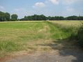
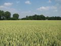
the way to the hash
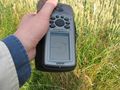
somewhere near the hash
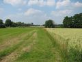
view to the north from the hash
view to the west, where I came from
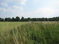
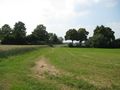
view to the south from the hash
view to the east from the hash
not really the hash, only some meters away


Achievements
GeorgDerReisende achieved level 2 of the Minesweeper Geohash achievement
|
GeorgDerReisende earned the Multihash Achievement
|