Difference between revisions of "2013-07-15 52 1"
From Geohashing
imported>Sourcerer m (→Other Expeditions this Day) |
imported>FippeBot m (Location) |
||
| (3 intermediate revisions by one other user not shown) | |||
| Line 1: | Line 1: | ||
{{meetup graticule | {{meetup graticule | ||
| − | | lat=52 | + | | lat=52 |
| − | | lon=1 | + | | lon=1 |
| − | | date=2013-07-15 | + | | date=2013-07-15 |
| + | | graticule_name=Norwich, UK | ||
| + | | graticule_link=Norwich, United Kingdom | ||
}} | }} | ||
| − | |||
__NOTOC__ | __NOTOC__ | ||
== Location == | == Location == | ||
| Line 13: | Line 14: | ||
[[User:Sourcerer|Sourcerer]] | [[User:Sourcerer|Sourcerer]] | ||
| − | == Expedition == | + | == Expedition - Fail == |
*Nearly Arrived. -- [[User:Sourcerer|Sourcerer]] ([[User talk:Sourcerer|talk]]) [http://www.openstreetmap.org/?lat=52.58655846118927&lon=1.7034655809402466&zoom=16&layers=B000FTF @52.5866,1.7035] 16:45, 15 July 2013 (GMT+01:00) | *Nearly Arrived. -- [[User:Sourcerer|Sourcerer]] ([[User talk:Sourcerer|talk]]) [http://www.openstreetmap.org/?lat=52.58655846118927&lon=1.7034655809402466&zoom=16&layers=B000FTF @52.5866,1.7035] 16:45, 15 July 2013 (GMT+01:00) | ||
| Line 25: | Line 26: | ||
[[File:2013-07-15 52 1 Sourcerer.jpg]] | [[File:2013-07-15 52 1 Sourcerer.jpg]] | ||
| − | == | + | {{Sourcerer_links |
| − | + | | prev = 2013-07-14 52 1 | |
| − | + | | curr = 2013-07-15 52 1 | |
| + | | next = 2013-08-28 52 1 | ||
| + | | date = 2013-07-15 | ||
| + | }} | ||
[[Category:Expeditions]] | [[Category:Expeditions]] | ||
| Line 33: | Line 37: | ||
[[Category:Coordinates not reached]] | [[Category:Coordinates not reached]] | ||
[[Category:Not reached - No public access]] | [[Category:Not reached - No public access]] | ||
| + | {{location|GB|ENG|NFK}} | ||
Latest revision as of 03:11, 14 August 2019
| Mon 15 Jul 2013 in Norwich, UK: 52.5865881, 1.7034166 geohashing.info google osm bing/os kml crox |
Location
A back garden close to Great Yarmouth, Norfolk, UK.
Participants
Expedition - Fail
- Nearly Arrived. -- Sourcerer (talk) @52.5866,1.7035 16:45, 15 July 2013 (GMT+01:00)
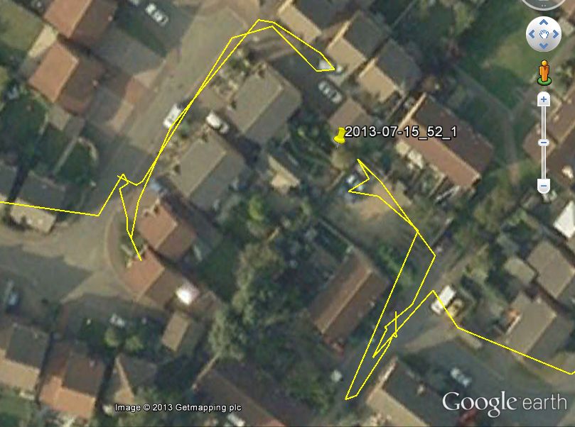
Approaching the hashpoint from two directions, it was impossible to reach without going into a private back garden. With no sign of the residents and not wanting to upset the locals, the expedition was abandoned.
Oddly, today I was closer to the hashpoint than yesterday but today I'm not claiming to have reached the point. Yesterday, the point was totally reachable but I chose not to trample crops but claimed "coordinates reached". This makes sense to me. Do others agree? Both times I could see the destination and it was only a few paces away.
Tracklog
Expeditions and Plans
| 2013-07-15 | ||
|---|---|---|
| Santa Ana, California | Todd Sheaman, LucasBrown | On a short walking trail (really just a power line access road in disguise)... |
| Würzburg, Germany | Someone went | In a field near Lauda-Königshofen. |
| Erfurt, Germany | Jens, Räbe | In a forest near Erkmannsdorf |
| Frankfurt am Main, Germany | GeorgDerReisende, Yakamoz | The hash lies in a small forest in Gießen. |
| Fulda, Germany | GeorgDerReisende | The hash lies near the northern junction of Fulda to the motorway A7. |
| Dortmund, Germany | GeorgDerReisende | The hash lies near the motorway interchange Kamener Kreuz. |
| Paderborn, Germany | GeorgDerReisende | The hash of today lies in the middle of the motorway A44 shortly west of th... |
| Norwich, United Kingdom | Sourcerer | A back garden close to Great Yarmouth, Norfolk, UK. |
| Moscow, Russia | vb | What appears to be the north-east boundary of East Biryulevo district. |
Sourcerer's Expedition Links
2013-07-14 52 1 - 2013-07-15 52 1 - 2013-08-28 52 1 - KML file download of Sourcerer's expeditions for use with Google Earth.
