Difference between revisions of "2013-08-04 43 -116"
From Geohashing
imported>Michael5000 m (→Plans) |
imported>FippeBot m (Location) |
||
| (14 intermediate revisions by 3 users not shown) | |||
| Line 1: | Line 1: | ||
| − | |||
| − | |||
| − | |||
| − | |||
| − | |||
| − | |||
| − | |||
| − | |||
| − | |||
| − | |||
{{meetup graticule | {{meetup graticule | ||
| lat=43 | | lat=43 | ||
| Line 15: | Line 5: | ||
}} | }} | ||
| − | |||
__NOTOC__ | __NOTOC__ | ||
== Location == | == Location == | ||
| − | + | ||
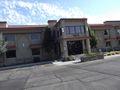
| + | The parking lot of the Hillcrest Business Center on Overland Road in Boise. | ||
== Participants == | == Participants == | ||
| − | + | ||
| − | + | *[[User:Eldin|Eldin]] | |
| + | |||
| + | *[[User:Michael5000|Michael5000]] | ||
== Plans == | == Plans == | ||
*[[User:Michael5000|Michael5000]] -- Oh my, this is some very low-hanging fruit on the geohashing tree. I will make an attempt on it on my way out of town and, since I suspect others may have their eyes on it too, I'll try to leave some sort of marker. | *[[User:Michael5000|Michael5000]] -- Oh my, this is some very low-hanging fruit on the geohashing tree. I will make an attempt on it on my way out of town and, since I suspect others may have their eyes on it too, I'll try to leave some sort of marker. | ||
| + | |||
| + | *[[User:Eldin|Eldin]] I was definitely planning to make this one. If you post what time you plan to be there, I'll try to make it about the same time (assuming I see your post between when I wake up and when I set out). I'll shoot for being there about 9:00 AM unless I see a different proposed time. | ||
== Expedition == | == Expedition == | ||
| − | |||
| − | == | + | |
| − | + | *At the hash. No sign that anyone else has been here yet. I've got a couple of errands to run nearby, so I'll check back at the point afterwards. -- [[User:Eldin|Eldin]] ([[User talk:Eldin|talk]]) [http://www.openstreetmap.org/?lat=43.58994012&lon=-116.23985453&zoom=16&layers=B000FTF @43.5899,-116.2399] 09:28, 4 August 2013 (MDT) | |
| + | |||
| + | *I woke up a bit late -- I'm still on Pacific Time -- and so I was at the site between 10:20 and 10:35. A car pulled through at one point, and I gave a friendly wave, but it was just some people using the lot to turn around in. [[User:Michael5000|Michael5000]] 18:27, 4 August 2013 (EDT) | ||
| + | |||
| + | *Back at the hash. And of course, Michael5000 came and went between my two visits. -- [[User:Eldin|Eldin]] ([[User talk:Eldin|talk]]) [http://www.openstreetmap.org/?lat=43.58994648&lon=-116.23985008&zoom=16&layers=B000FTF @43.5899,-116.2399] 10:55, 4 August 2013 (MDT) | ||
== Photos == | == Photos == | ||
| − | < | + | ===[[User:Eldin|Eldin]]=== |
| − | Image: | + | <gallery> |
| − | --> | + | |
| − | <gallery | + | File:2013-08-04 43 -116 proof.jpg | Proof that we were in the right place. |
| + | |||
| + | File:2013-08-04 43 -116 grins.jpg | [[User:Eldin|Eldin]] & Pojana grinning at the hashpoint. | ||
| + | |||
| + | File:2013-08-04 43 -116 point.jpg | The actual hashpoint was in the parking space to the right of the sign here. | ||
| + | |||
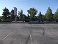
| + | File:2013-08-04 43 -116 building.jpg | The building belonging to the parking lot with the hash. | ||
| + | |||
| + | Image:2013-08-04_43_-116_10-59-37-472.jpg | Mark left on 2nd visit. X marks the #. | ||
| + | |||
| + | Image:2013-08-04_43_-116_11-01-44-479.jpg | Back of card left by Michael. | ||
| + | |||
| + | Image:2013-08-04_43_-116_11-02-20-782.jpg | And the front. | ||
| + | </gallery> | ||
| + | ===[[User:Michael5000]]=== | ||
| + | <gallery> | ||
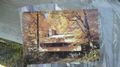
| + | File:2013-08-04 43 -116 sign.JPG | Another glamorous hashpoint location! | ||
</gallery> | </gallery> | ||
== Achievements == | == Achievements == | ||
{{#vardefine:ribbonwidth|800px}} | {{#vardefine:ribbonwidth|800px}} | ||
| − | |||
| − | |||
| − | + | {{Land geohash|name=[[User:Eldin|Eldin]] & [[User:Michael5000|Michael5000]]|latitude=43|longitude=-116|date=2013-08-04}} | |
| − | + | {{consecutive geohash 2 | count = 2 | latitude = 43 | longitude = -116 | date = 2013-08-03 | name = [[User:Eldin|Eldin]]}} | |
| − | [[ | ||
| − | |||
| − | |||
| − | |||
[[Category:Expeditions]] | [[Category:Expeditions]] | ||
| − | |||
[[Category:Expeditions with photos]] | [[Category:Expeditions with photos]] | ||
| − | |||
| − | |||
| − | |||
| − | |||
| − | |||
[[Category:Coordinates reached]] | [[Category:Coordinates reached]] | ||
| − | + | {{location|US|ID|AA}} | |
| − | |||
| − | |||
| − | |||
| − | |||
| − | |||
| − | |||
| − | |||
| − | |||
| − | |||
| − | |||
| − | |||
| − | |||
| − | |||
| − | |||
| − | |||
| − | |||
| − | |||
Latest revision as of 03:27, 14 August 2019
| Sun 4 Aug 2013 in 43,-116: 43.5899243, -116.2398594 geohashing.info google osm bing/os kml crox |
Location
The parking lot of the Hillcrest Business Center on Overland Road in Boise.
Participants
Plans
- Michael5000 -- Oh my, this is some very low-hanging fruit on the geohashing tree. I will make an attempt on it on my way out of town and, since I suspect others may have their eyes on it too, I'll try to leave some sort of marker.
- Eldin I was definitely planning to make this one. If you post what time you plan to be there, I'll try to make it about the same time (assuming I see your post between when I wake up and when I set out). I'll shoot for being there about 9:00 AM unless I see a different proposed time.
Expedition
- At the hash. No sign that anyone else has been here yet. I've got a couple of errands to run nearby, so I'll check back at the point afterwards. -- Eldin (talk) @43.5899,-116.2399 09:28, 4 August 2013 (MDT)
- I woke up a bit late -- I'm still on Pacific Time -- and so I was at the site between 10:20 and 10:35. A car pulled through at one point, and I gave a friendly wave, but it was just some people using the lot to turn around in. Michael5000 18:27, 4 August 2013 (EDT)
- Back at the hash. And of course, Michael5000 came and went between my two visits. -- Eldin (talk) @43.5899,-116.2399 10:55, 4 August 2013 (MDT)
Photos
Eldin
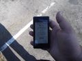
Proof that we were in the right place.

Eldin & Pojana grinning at the hashpoint.
The actual hashpoint was in the parking space to the right of the sign here.
The building belonging to the parking lot with the hash.

Mark left on 2nd visit. X marks the #.
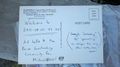
Back of card left by Michael.
And the front.


User:Michael5000

Another glamorous hashpoint location!

Achievements
Eldin & Michael5000 earned the Land geohash achievement
|
Eldin earned the Consecutive geohash achievement
|