Difference between revisions of "2013-08-31 42 2"
imported>Dunaril ([live picture] [http://www.openstreetmap.org/?lat=42.92290000&lon=2.26328000&zoom=16&layers=B000FTF @42.9229,2.2633]) |
m (per Renaming Proposal) |
||
| (12 intermediate revisions by 2 users not shown) | |||
| Line 1: | Line 1: | ||
| − | + | [[Image:{{{image|2013-08-31_42_2_15-06-14-392.jpg}}}|thumb|left]] | |
| − | [[Image:{{{image| | ||
| − | |||
{{meetup graticule | {{meetup graticule | ||
| Line 16: | Line 14: | ||
== Participants == | == Participants == | ||
| + | |||
[[User:Dunaril|Dunaril]] and family. | [[User:Dunaril|Dunaril]] and family. | ||
== Plans == | == Plans == | ||
| + | |||
We are on our way from vacation, road tripping today from Collioure to Gaillac. I have successfully bended our itinerary to pass by this geohash, and potentially another one just North of here. We'll see if the point is really reachable. | We are on our way from vacation, road tripping today from Collioure to Gaillac. I have successfully bended our itinerary to pass by this geohash, and potentially another one just North of here. We'll see if the point is really reachable. | ||
== Expedition == | == Expedition == | ||
| − | |||
| − | + | We were following a road west of the geohash and it wasn't much of a detour (a few kilometers) to get on the road closer to it. At least I thought so. | |
| − | + | The region is quite slopy, with lots of small rivers perfect for kayaking and rafting. We ended up leaving the main road on what seemed the most direct road to the geohash according to Google Maps - only to find that it was on the wrong bank of such a river, and that it was even turning into a small trail that we couldn't follow with the car. We were quite pressed so we couldn't go on a walk from there. Besides, given the unexpected rough geography and the satellite view of the hash, I was beginning to feel the hash could be simply unreachable, although close to a road. | |
| − | + | We turned back and made it for the close town of Rennes-le-Château. We stopped and had a picnic south of the city, just 700m North of the hash. From there 700m seemed like a long way - the so-called closest road to the hash was in fact a steep rocky trail, and it wasn't obvious I could leave it and cross the stream I had observed on the map. While my family was going North for a visit of the village, giving up on the hash, I decided to try my luck anyway and get as close as I could to it. | |
| − | + | ||
| − | + | The trail was very rewarding, with a beautiful scenery (see photos below) and a small tower just 200m from the hash. When I got to the point where the streamed had to be crossed in some way, I found a little trail already leaving the bigger one and crossing it straight towards the hash location. There was no difficulty and I reached the rocky, not too steep slope where the hash was waiting. After some pinpointing with the amazing Geohash Droid app, I got a positive gps read and took the necessary proof, and then took the exact same way back to the village. We met there and left the place to continue our road trip! | |
| − | + | ||
| + | == Photos == | ||
<gallery perrow="5"> | <gallery perrow="5"> | ||
Image:2013-08-31_42_2_12-05-32-500.jpg | The place we left this morning. Collioure is so beautiful. On our way now. [http://www.openstreetmap.org/?lat=42.51480000&lon=3.08800000&zoom=16&layers=B000FTF @42.5148,3.0880] | Image:2013-08-31_42_2_12-05-32-500.jpg | The place we left this morning. Collioure is so beautiful. On our way now. [http://www.openstreetmap.org/?lat=42.51480000&lon=3.08800000&zoom=16&layers=B000FTF @42.5148,3.0880] | ||
| − | Image:2013-08-31_42_2_14-50-22-916.jpg | | + | Image:2013-08-31_42_2_15-46-24-691.jpg | Balcon view in the morning. [http://www.openstreetmap.org/?lat=42.52530000&lon=3.07948000&zoom=16&layers=B000FTF @42.5253,3.0795] |
| + | |||
| + | Image:2013-08-31_42_2_15-11-57-087.jpg | Taken close to the Rennes-le-château village - the geolocation is erroneous. The geohash's rocky slope is right at the center of the picture, between the branches. | ||
| + | |||
| + | Image:2013-08-31_42_2_15-05-43-925.jpg | The village of Rennes-le-Château, viewed from the trail to the geohash [http://www.openstreetmap.org/?lat=42.92290000&lon=2.26327000&zoom=16&layers=B000FTF @42.9229,2.2633] | ||
| + | |||
| + | Image:2013-08-31_42_2_14-50-22-916.jpg | A small tower overlooking the geohash location [http://www.openstreetmap.org/?lat=42.92290000&lon=2.26328000&zoom=16&layers=B000FTF @42.9229,2.2633] | ||
| + | |||
| + | Image:2013-08-31_42_2_15-07-36-828.jpg | Closing on the geohash: the tower is outside the picture on the right, and the hash is visible on the rocky slop in the middle-left of the picture. | ||
| + | |||
| + | Image:2013-08-31_42_2_15-08-07-221.jpg | The only obstacle on the way: a small stream. | ||
| + | |||
| + | Image:2013-08-31_42_2_15-06-14-392.jpg | Taken at the geohash location - tower and village below. I couldn't geotag and upload it on the spot because there was no network. | ||
| + | |||
| + | Image:2013-08-31_42_2_15-08-52-870.jpg | Proof 1: Geohash Droid radar view on the hash point. | ||
| + | |||
| + | Image:2013-08-31_42_2_15-09-15-168.jpg | Proof 2: Geohash Droid map view on the same spot (the gps was already on its way back). | ||
| + | |||
</gallery> | </gallery> | ||
== Achievements == | == Achievements == | ||
{{#vardefine:ribbonwidth|800px}} | {{#vardefine:ribbonwidth|800px}} | ||
| − | + | {{land geohash | latitude = 42 | longitude = 2 | date = 2013-08-31 | name = [[User:Dunaril|Dunaril]]}} | |
| + | {{Graticule unlocked | latitude = 42 | longitude = 2 | date = 2013-08-31 | name = [[User:Dunaril|Dunaril]]}} | ||
| − | |||
| − | |||
| − | |||
[[Category:Expeditions]] | [[Category:Expeditions]] | ||
| − | |||
[[Category:Expeditions with photos]] | [[Category:Expeditions with photos]] | ||
| − | |||
| − | |||
| − | |||
| − | |||
[[Category:Coordinates reached]] | [[Category:Coordinates reached]] | ||
| − | + | {{location|FR|11}} | |
| − | |||
| − | |||
| − | |||
| − | |||
| − | |||
| − | |||
| − | |||
| − | |||
| − | |||
| − | |||
| − | |||
| − | |||
| − | |||
| − | |||
| − | |||
| − | |||
| − | |||
Latest revision as of 05:21, 20 March 2024

| Sat 31 Aug 2013 in 42,2: 42.9194046, 2.2660901 geohashing.info google osm bing/os kml crox |
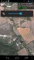
Location
In Rennes-le-Château, not far from the road, on some rocky place surrounded by a small stream (reachability unknown at this point).
Participants
Dunaril and family.
Plans
We are on our way from vacation, road tripping today from Collioure to Gaillac. I have successfully bended our itinerary to pass by this geohash, and potentially another one just North of here. We'll see if the point is really reachable.
Expedition
We were following a road west of the geohash and it wasn't much of a detour (a few kilometers) to get on the road closer to it. At least I thought so. The region is quite slopy, with lots of small rivers perfect for kayaking and rafting. We ended up leaving the main road on what seemed the most direct road to the geohash according to Google Maps - only to find that it was on the wrong bank of such a river, and that it was even turning into a small trail that we couldn't follow with the car. We were quite pressed so we couldn't go on a walk from there. Besides, given the unexpected rough geography and the satellite view of the hash, I was beginning to feel the hash could be simply unreachable, although close to a road.
We turned back and made it for the close town of Rennes-le-Château. We stopped and had a picnic south of the city, just 700m North of the hash. From there 700m seemed like a long way - the so-called closest road to the hash was in fact a steep rocky trail, and it wasn't obvious I could leave it and cross the stream I had observed on the map. While my family was going North for a visit of the village, giving up on the hash, I decided to try my luck anyway and get as close as I could to it.
The trail was very rewarding, with a beautiful scenery (see photos below) and a small tower just 200m from the hash. When I got to the point where the streamed had to be crossed in some way, I found a little trail already leaving the bigger one and crossing it straight towards the hash location. There was no difficulty and I reached the rocky, not too steep slope where the hash was waiting. After some pinpointing with the amazing Geohash Droid app, I got a positive gps read and took the necessary proof, and then took the exact same way back to the village. We met there and left the place to continue our road trip!
Photos
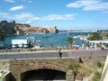
The place we left this morning. Collioure is so beautiful. On our way now. @42.5148,3.0880
Balcon view in the morning. @42.5253,3.0795
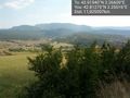
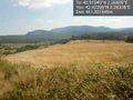
Taken close to the Rennes-le-château village - the geolocation is erroneous. The geohash's rocky slope is right at the center of the picture, between the branches.
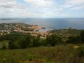
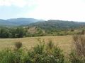
The village of Rennes-le-Château, viewed from the trail to the geohash @42.9229,2.2633
A small tower overlooking the geohash location @42.9229,2.2633
Closing on the geohash: the tower is outside the picture on the right, and the hash is visible on the rocky slop in the middle-left of the picture.
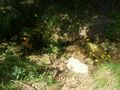
The only obstacle on the way: a small stream.

Taken at the geohash location - tower and village below. I couldn't geotag and upload it on the spot because there was no network.
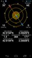
Proof 1: Geohash Droid radar view on the hash point.
Proof 2: Geohash Droid map view on the same spot (the gps was already on its way back).


Achievements
Dunaril earned the Land geohash achievement
|
Dunaril earned the Graticule Unlocked Achievement
|