Difference between revisions of "2013-09-02 45 -122"
imported>Frogman (Created page with "{{subst:Expedition |lat = 45 |lon = -122 |date = 2013-09-02 }}") |
imported>FippeBot m (Location) |
||
| (9 intermediate revisions by 3 users not shown) | |||
| Line 15: | Line 15: | ||
}} | }} | ||
| − | + | ||
__NOTOC__ | __NOTOC__ | ||
== Location == | == Location == | ||
| − | + | Off of the path in Forest Park. | |
== Participants == | == Participants == | ||
| − | + | ||
| − | + | * [[User:Frogman|Frogman]] and | |
| + | * Alison and | ||
| + | * Frogman's grandpa | ||
== Plans == | == Plans == | ||
| − | + | We planned on going on a nice hike in Forest Park and seeing if the hashpoint was easily accessible (despite Forest Park's stay-on-the-trail policy). | |
== Expedition == | == Expedition == | ||
| − | + | After a pleasant hike, we reached the proximity of the hashpoint. While we passed within 50 meters on the east and west and within 100 meters on the north and south, we determined that the hashpoint was inaccessible even with our slightly lax interpretation of the stay-on-the-trail rule. The hashpoint was definitely physically accessible, but too far off of the trail and in dense vegetation. Even though the expedition was thwarted it was nice to get out of the house and on this beautiful trail. | |
== Tracklog == | == Tracklog == | ||
| Line 34: | Line 36: | ||
== Photos == | == Photos == | ||
| − | |||
| − | |||
| − | |||
<gallery perrow="5"> | <gallery perrow="5"> | ||
| + | Image:2013-09-02 45 -122 coordinates.jpg | Close, but not close enough... | ||
| + | Image:2013-09-02 45 -122 marking.jpg | We left a sign for other geohashers. | ||
| + | Image:2013-09-02 45 -122 goofiest grin.jpg | Alison's goofy grin, and Grandpa is in the background | ||
</gallery> | </gallery> | ||
| Line 44: | Line 46: | ||
<!-- Add any achievement ribbons you earned below, or remove this section --> | <!-- Add any achievement ribbons you earned below, or remove this section --> | ||
| + | {{drag-along | ||
| + | | latitude = 45 | ||
| + | | longitude = -122 | ||
| + | | date = 2013-09-02 | ||
| + | | partner = Grandpa John | ||
| + | | name = [[User:Frogman|Frogman]] ([[User talk:Frogman|talk]]) | ||
| + | }} | ||
| − | + | {{No trespassing | |
| − | + | | latitude = 45 | |
| − | [[ | + | | longitude = -122 |
| − | + | | date = 2013-09-02 | |
| − | + | | name = [[User:Frogman|Frogman]] ([[User talk:Frogman|talk]]), Frogman's grandpa, Alison | |
| − | + | | distance = 40 meters | |
| − | [[ | + | }} |
| − | |||
| − | |||
[[Category:Expeditions]] | [[Category:Expeditions]] | ||
| − | |||
[[Category:Expeditions with photos]] | [[Category:Expeditions with photos]] | ||
| − | |||
| − | |||
| − | |||
| − | |||
| − | |||
| − | |||
| − | |||
[[Category:Coordinates not reached]] | [[Category:Coordinates not reached]] | ||
| − | |||
| − | |||
| − | |||
| − | |||
| − | |||
[[Category:Not reached - No public access]] | [[Category:Not reached - No public access]] | ||
| − | + | {{location|US|OR|MU}} | |
| − | |||
| − | |||
| − | |||
| − | |||
| − | |||
| − | |||
| − | |||
Latest revision as of 03:49, 14 August 2019
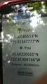
| Mon 2 Sep 2013 in 45,-122: 45.6028551, -122.8134778 geohashing.info google osm bing/os kml crox |
Location
Off of the path in Forest Park.
Participants
- Frogman and
- Alison and
- Frogman's grandpa
Plans
We planned on going on a nice hike in Forest Park and seeing if the hashpoint was easily accessible (despite Forest Park's stay-on-the-trail policy).
Expedition
After a pleasant hike, we reached the proximity of the hashpoint. While we passed within 50 meters on the east and west and within 100 meters on the north and south, we determined that the hashpoint was inaccessible even with our slightly lax interpretation of the stay-on-the-trail rule. The hashpoint was definitely physically accessible, but too far off of the trail and in dense vegetation. Even though the expedition was thwarted it was nice to get out of the house and on this beautiful trail.
Tracklog
Photos
Close, but not close enough...
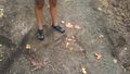
We left a sign for other geohashers.
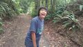
Alison's goofy grin, and Grandpa is in the background


Achievements
Frogman (talk) earned the Drag-along achievement
|
Frogman (talk), Frogman's grandpa, Alison earned the No trespassing consolation prize
|