Difference between revisions of "2013-09-05 45 -123"
imported>Eldin (An expedition message sent via Geohash Droid for Android.) |
imported>FippeBot m (Location) |
||
| (5 intermediate revisions by one other user not shown) | |||
| Line 1: | Line 1: | ||
| − | |||
| − | |||
| − | |||
| − | |||
| − | |||
| − | |||
| − | |||
| − | |||
| − | |||
| − | |||
{{meetup graticule | {{meetup graticule | ||
| lat=45 | | lat=45 | ||
| Line 15: | Line 5: | ||
}} | }} | ||
| − | |||
__NOTOC__ | __NOTOC__ | ||
== Location == | == Location == | ||
| − | + | In the forest north of Nehalem. | |
| + | |||
== Participants == | == Participants == | ||
| − | + | * [[User:Eldin|Eldin]] | |
| − | + | * Eldin's dad | |
| − | |||
| − | |||
| − | |||
== Expedition == | == Expedition == | ||
| − | + | When we set out, we were thinking (based on Google maps/satelite imagery) that we would be able to drive nearly to the hash. But about 1.4 miles from the hash we encountered a locked gate. However, the sign beside the locked gate indicated that certain recreational uses of the land beyond were permitted, including hiking (during daylight hours only). So we parked the car and set out walking. It was a beautiful area for hiking through the forest, and we were able to find roads and/or trails which led is roughly the right direction. We saw signs of deer and bear, but the only wildlife we actually encountered were a frog and a lizard. It ended up taking 1.5 hours and roughly 2 miles of hiking with a fair bit of vertical travel (both up and down) to reach the hash. The hash itself was near a very large tree stump, at the top of a hill, near the edge of a recently logged area of forest. The view of Nehalem Bay from the hash was quite spectacular. When we were almost to the hash, it started raining. It stopped again after only 10 minutes or so, but it began again shortly after we left the hash point, and continued for nearly the entire hike back to the car. | |
| − | |||
| − | |||
| − | |||
== Photos == | == Photos == | ||
| − | |||
| − | |||
| − | |||
<gallery perrow="5"> | <gallery perrow="5"> | ||
| + | File:2013-09-05 45 -123 proof.jpg | Proof that we reached the spot. | ||
| + | File:2013-09-05 45 -123 grins.jpg | My dad and I at the hashpoint. | ||
| + | File:2013-09-05 45 -123 gate.jpg | The gate that kept my car out... | ||
| + | File:2013-09-05 45 -123 sign.jpg | and the sign that let us walk in. | ||
| + | File:2013-09-05 45 -123 stump.jpg | Quite a large tree stump within a couple meters of the point. | ||
| + | File:2013-09-05 45 -123 view1.jpg | The view looking back towards Nehalem. | ||
| + | File:2013-09-05 45 -123 view2.jpg | And the view looking north. The hash was right at the edge of a recently logged area. | ||
</gallery> | </gallery> | ||
== Achievements == | == Achievements == | ||
{{#vardefine:ribbonwidth|800px}} | {{#vardefine:ribbonwidth|800px}} | ||
| − | + | {{Land geohash|date=2013-09-05|latitude=45|longitude=-123|name=[[User:Eldin|Eldin]] & his dad}} | |
| + | {{drag-along| latitude = 45| longitude = -123| date = 2013-09-05| partner = his dad| name = [[User:Eldin|Eldin]]}} | ||
| + | {{Drowned rat geohash| latitude = 45| longitude = -123| date = 2013-09-05| name = [[User:Eldin|Eldin]] & his dad| reason = walking ~2 miles through rainy forest}} | ||
| + | ''I debated whether to take the honorable mention version of this one. But yesterday my mom made a comment about seeing us after the expedition. She said 'They looked like a couple of drowned rats'. That convinced me that the full version was in fact appropriate.'' | ||
| − | |||
| − | |||
| − | |||
| − | |||
| − | |||
| − | |||
| − | |||
| − | |||
| − | |||
| − | |||
[[Category:Expeditions]] | [[Category:Expeditions]] | ||
| − | |||
[[Category:Expeditions with photos]] | [[Category:Expeditions with photos]] | ||
| − | |||
| − | |||
| − | |||
| − | |||
| − | |||
[[Category:Coordinates reached]] | [[Category:Coordinates reached]] | ||
| − | + | {{location|US|OR|TI}} | |
| − | |||
| − | |||
| − | |||
| − | |||
| − | |||
| − | |||
| − | |||
| − | |||
| − | |||
| − | |||
| − | |||
| − | |||
| − | |||
| − | |||
| − | |||
| − | |||
| − | |||
Latest revision as of 03:51, 14 August 2019
| Thu 5 Sep 2013 in 45,-123: 45.7402717, -123.9119981 geohashing.info google osm bing/os kml crox |
Location
In the forest north of Nehalem.
Participants
- Eldin
- Eldin's dad
Expedition
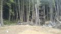
When we set out, we were thinking (based on Google maps/satelite imagery) that we would be able to drive nearly to the hash. But about 1.4 miles from the hash we encountered a locked gate. However, the sign beside the locked gate indicated that certain recreational uses of the land beyond were permitted, including hiking (during daylight hours only). So we parked the car and set out walking. It was a beautiful area for hiking through the forest, and we were able to find roads and/or trails which led is roughly the right direction. We saw signs of deer and bear, but the only wildlife we actually encountered were a frog and a lizard. It ended up taking 1.5 hours and roughly 2 miles of hiking with a fair bit of vertical travel (both up and down) to reach the hash. The hash itself was near a very large tree stump, at the top of a hill, near the edge of a recently logged area of forest. The view of Nehalem Bay from the hash was quite spectacular. When we were almost to the hash, it started raining. It stopped again after only 10 minutes or so, but it began again shortly after we left the hash point, and continued for nearly the entire hike back to the car.
Photos
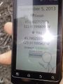
Proof that we reached the spot.
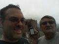
My dad and I at the hashpoint.
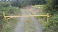
The gate that kept my car out...
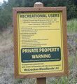
and the sign that let us walk in.
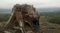
Quite a large tree stump within a couple meters of the point.
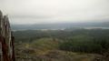
The view looking back towards Nehalem.
And the view looking north. The hash was right at the edge of a recently logged area.


Achievements
Eldin & his dad earned the Land geohash achievement
|
Eldin earned the Drag-along achievement
|
Eldin & his dad earned the Drowned Rat Geohash Achievement
|
I debated whether to take the honorable mention version of this one. But yesterday my mom made a comment about seeing us after the expedition. She said 'They looked like a couple of drowned rats'. That convinced me that the full version was in fact appropriate.