Difference between revisions of "2007-09-06 -35 149"
From Geohashing
imported>1PE (Created page with "{{ subst:Expedition |lat = -35|lon = 149|date = 2007-09-06 }}") |
m (More specific location) |
||
| (5 intermediate revisions by 4 users not shown) | |||
| Line 13: | Line 13: | ||
| lon=149 | | lon=149 | ||
| date=2007-09-06 | | date=2007-09-06 | ||
| + | | retro=1 | ||
}} | }} | ||
| Line 18: | Line 19: | ||
__NOTOC__ | __NOTOC__ | ||
== Location == | == Location == | ||
| − | + | A concrete walking path near a roundabout in south Jerrabombera, a dormitory suburb among the low hills to the east of Canberra. | |
== Participants == | == Participants == | ||
| − | + | * [[User:1PE|1PE]] | |
| − | |||
== Plans == | == Plans == | ||
| − | + | * [[User:1PE|1PE]] - lunchtime excursion | |
== Expedition == | == Expedition == | ||
| − | + | * [[User:1PE|1PE]] | |
| − | + | ** It was my birthday, but the hash on 2013-09-06 was a long way into impossible. So, I went 'retro'. | |
| − | + | ** I got lost. I turned my car the wrong way on a major road (Bicentennial Drive) leading to the hash. After a while, I worked out how to get across a 'link' road to the other side of the major rood loop. Then, it was easy. | |
| − | |||
== Photos == | == Photos == | ||
| Line 38: | Line 37: | ||
--> | --> | ||
<gallery perrow="5"> | <gallery perrow="5"> | ||
| + | Image:2007-09-06_-35_14913.07.42.jpg|A roundabout, and THE path. | ||
| + | Image:2013-09-06_-35_149_13.08.18.jpg|Yes, there on the ground. | ||
</gallery> | </gallery> | ||
| Line 45: | Line 46: | ||
| − | |||
| − | |||
| − | |||
| − | |||
| − | |||
| − | |||
| − | |||
| − | |||
| − | |||
| − | |||
| − | |||
| − | |||
[[Category:Expeditions with photos]] | [[Category:Expeditions with photos]] | ||
| − | |||
| − | |||
| − | |||
| − | + | [[Category:Retro coordinates reached]] | |
| − | [[Category: | + | [[Category:Retro meetup]] |
| − | + | {{location|AU|NSW|QB}} | |
| − | |||
| − | |||
| − | [[Category: | ||
| − | |||
| − | |||
| − | |||
| − | |||
| − | |||
| − | |||
| − | |||
| − | |||
| − | |||
| − | |||
| − | |||
| − | |||
| − | |||
| − | |||
Latest revision as of 11:19, 1 August 2020
| Thu 6 Sep 2007 in -35,149: -35.3987304, 149.2049915 geohashing.info google osm bing/os kml crox |
Location
A concrete walking path near a roundabout in south Jerrabombera, a dormitory suburb among the low hills to the east of Canberra.
Participants
Plans
- 1PE - lunchtime excursion
Expedition
- 1PE
- It was my birthday, but the hash on 2013-09-06 was a long way into impossible. So, I went 'retro'.
- I got lost. I turned my car the wrong way on a major road (Bicentennial Drive) leading to the hash. After a while, I worked out how to get across a 'link' road to the other side of the major rood loop. Then, it was easy.
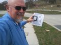
Photos
A roundabout, and THE path.

Yes, there on the ground.

