Difference between revisions of "2013-09-27 55 37"
From Geohashing
imported>Vb (→Photos) |
imported>FippeBot m (Location) |
||
| (12 intermediate revisions by one other user not shown) | |||
| Line 19: | Line 19: | ||
== Location == | == Location == | ||
<!-- where you've surveyed the hash to be --> | <!-- where you've surveyed the hash to be --> | ||
| + | |||
| + | Kosygin street. | ||
== Participants == | == Participants == | ||
<!-- who attended: If you link to your wiki user name in this section, your expedition will be picked up by the various statistics generated for geohashing. You may use three tildes ~ as a shortcut to automatically insert the user signature of the account you are editing with. | <!-- who attended: If you link to your wiki user name in this section, your expedition will be picked up by the various statistics generated for geohashing. You may use three tildes ~ as a shortcut to automatically insert the user signature of the account you are editing with. | ||
--> | --> | ||
| − | + | [[User:Vb|vb]] | |
| − | |||
| − | |||
== Expedition == | == Expedition == | ||
<!-- how it all turned out. your narrative goes here. --> | <!-- how it all turned out. your narrative goes here. --> | ||
| + | |||
| + | Walk. Midnight. | ||
*On the question of google maps satellite imagery accuracy. My phone's GPS consistently shows hash about 6m away from what it appears on the map - across the road. -- [[User:Vb|vb]] ([[User talk:Vb|talk]]) 15:12, 26 September 2013 (EDT) | *On the question of google maps satellite imagery accuracy. My phone's GPS consistently shows hash about 6m away from what it appears on the map - across the road. -- [[User:Vb|vb]] ([[User talk:Vb|talk]]) 15:12, 26 September 2013 (EDT) | ||
| + | |||
| + | *Have to revoke my previous statement. It seems that phone's GPS is actually less accutate than it pretends to be. By the way it's around 2°C and hard to type. -- [[User:Vb|vb]] ([[User talk:Vb|talk]]) [http://www.openstreetmap.org/?lat=55.70700298&lon=37.56876867&zoom=16&layers=B000FTF @55.7070,37.5688] 16:06, 26 September 2013 (EDT) | ||
== Tracklog == | == Tracklog == | ||
<!-- if your GPS device keeps a log, you may post a link here --> | <!-- if your GPS device keeps a log, you may post a link here --> | ||
| + | |||
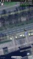
| + | [[Image:2013-09-27 55 37 Tracklog.jpg|250px]] | ||
| + | |||
| + | At some point near the end of the trip recording stopped for some reason. The purple part is drawn by hand. | ||
| + | |||
| + | 16.8km | ||
== Photos == | == Photos == | ||
| Line 50: | Line 60: | ||
Image:2013-09-27_55_37_23-06-47-498.jpg | | Image:2013-09-27_55_37_23-06-47-498.jpg | | ||
| + | |||
| + | Image:2013-09-27_55_37_23-47-03-718.jpg | New bicycle sharing system. Unrelated. [http://www.openstreetmap.org/?lat=55.70620000&lon=37.55450000&zoom=16&layers=B000FTF @55.7062,37.5545] | ||
| + | |||
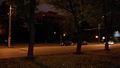
| + | Image:2013-09-27_55_37_00-01-42-271.jpg | Midnight [http://www.openstreetmap.org/?lat=55.70652510&lon=37.56582821&zoom=16&layers=B000FTF @55.7065,37.5658] | ||
</gallery> | </gallery> | ||
| Line 56: | Line 70: | ||
<!-- Add any achievement ribbons you earned below, or remove this section --> | <!-- Add any achievement ribbons you earned below, or remove this section --> | ||
| + | {{Midnight geohash | latitude = 55 | longitude = 37 | date = 2013-09-27 | name = [[User:Vb|vb]] }} | ||
| + | {{Walk geohash | latitude = 55 | longitude = 37 | date = 2013-09-27 | name = [[User:Vb|vb]] | distance = 16.8km | image = 2013-09-27_55_37_Tracklog.jpg }} | ||
| + | {{consecutive geohash 2 | count = 2 | latitude = 55 | longitude = 37 | date = 2013-09-27 | name = [[User:Vb|vb]] }} | ||
| − | |||
| − | |||
| − | |||
| − | |||
| − | |||
| − | |||
| − | |||
| − | |||
| − | |||
| − | |||
[[Category:Expeditions]] | [[Category:Expeditions]] | ||
| − | |||
[[Category:Expeditions with photos]] | [[Category:Expeditions with photos]] | ||
| − | |||
| − | |||
| − | |||
| − | |||
| − | |||
[[Category:Coordinates reached]] | [[Category:Coordinates reached]] | ||
| − | + | [[Category:Walk geohash achievement]] | |
| − | + | [[Category:Land geohash achievement]] | |
| − | + | [[Category:Midnight geohash achievement]] | |
| − | [[Category: | + | [[Category:Consecutive geohash achievement]] |
| − | + | {{location|RU|MOW}} | |
| − | |||
| − | [[Category: | ||
| − | |||
| − | |||
| − | [[Category: | ||
| − | |||
| − | |||
| − | [[Category: | ||
| − | |||
| − | |||
| − | |||
| − | |||
| − | |||
Latest revision as of 04:08, 14 August 2019
| Fri 27 Sep 2013 in 55,37: 55.7064000, 37.5644503 geohashing.info google osm bing/os kml crox |
Location
Kosygin street.
Participants
Expedition
Walk. Midnight.
- On the question of google maps satellite imagery accuracy. My phone's GPS consistently shows hash about 6m away from what it appears on the map - across the road. -- vb (talk) 15:12, 26 September 2013 (EDT)
- Have to revoke my previous statement. It seems that phone's GPS is actually less accutate than it pretends to be. By the way it's around 2°C and hard to type. -- vb (talk) @55.7070,37.5688 16:06, 26 September 2013 (EDT)
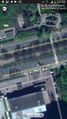
Tracklog

At some point near the end of the trip recording stopped for some reason. The purple part is drawn by hand.
16.8km
Photos
1hr too early
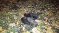
@55.7064,37.5645 somebody left their galoshes near the hash.
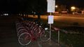
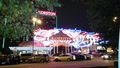
New bicycle sharing system. Unrelated. @55.7062,37.5545
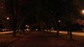
Midnight @55.7065,37.5658


Achievements
vb earned the Midnight Geohash achievement
|
vb earned the Walk geohash Achievement
|
vb earned the Consecutive geohash achievement
|