Difference between revisions of "2013-10-05 42 -72"
From Geohashing
imported>Pandrews |
imported>FippeBot m (Location) |
||
| (One intermediate revision by one other user not shown) | |||
| Line 21: | Line 21: | ||
== Photos == | == Photos == | ||
| − | <gallery perrow="5"> | + | <gallery caption="Photo Gallery" widths="200px" heights="200px" perrow="5"> |
Image:2013-10-05-42--72-IMG_1189.JPG | From left: Charlie, Rory, Theo | Image:2013-10-05-42--72-IMG_1189.JPG | From left: Charlie, Rory, Theo | ||
| Line 43: | Line 43: | ||
[[Category:Expeditions with photos]] | [[Category:Expeditions with photos]] | ||
[[Category:Coordinates reached]] | [[Category:Coordinates reached]] | ||
| + | {{location|US|MA|WO}} | ||
Latest revision as of 04:13, 14 August 2019
| Sat 5 Oct 2013 in 42,-72: 42.5288289, -72.2432313 geohashing.info google osm bing/os kml crox |
Location
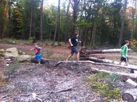
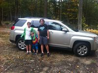
In a forest near Athol, Massachusetts
Participants
- Paul Andrews (behind camera). Then from left:
- Charlie
- Rory
- Theo
Plans
This was for a cub scout webelos achievement as planned by Theo.
Photos
- Photo Gallery
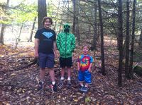
From left: Charlie, Rory, Theo


Achievements
Andrews Clan earned the Land geohash achievement
|