Difference between revisions of "2013-10-14 48 9"
From Geohashing
imported>RecentlyChanged (→Tracklog) |
imported>FippeBot m (Location) |
||
| (3 intermediate revisions by 2 users not shown) | |||
| Line 33: | Line 33: | ||
== Photos == | == Photos == | ||
| − | |||
| − | |||
| − | |||
<gallery perrow="5"> | <gallery perrow="5"> | ||
| + | Image:2013-10-14 48 9 thehashpoint.jpg| The Hashpoint | ||
| + | Image:2013-10-14 48 9 sleepy grin.jpg| Sleepy Grin | ||
</gallery> | </gallery> | ||
== Achievements == | == Achievements == | ||
{{#vardefine:ribbonwidth|800px}} | {{#vardefine:ribbonwidth|800px}} | ||
| − | + | {{land geohash | latitude = 48 | longitude = 9 | date = 2013-10-14 | name = [[User:RecentlyChanged|RecentlyChanged]] }} | |
| + | {{Minesweeper geohash | ||
| + | | graticule = Pforzheim, Germany | ||
| + | | ranknumber = 4 | ||
| + | | n = true | ||
| + | | e = true | ||
| + | | s = true | ||
| + | | w = true | ||
| + | | name = [[User:RecentlyChanged|RecentlyChanged]] | ||
| − | + | }} | |
| − | |||
| − | |||
| − | |||
| − | |||
| − | |||
| − | |||
| − | |||
| − | |||
[[Category:Expeditions]] | [[Category:Expeditions]] | ||
| − | |||
[[Category:Expeditions with photos]] | [[Category:Expeditions with photos]] | ||
| − | + | ||
| − | |||
| − | |||
| − | |||
| − | |||
[[Category:Coordinates reached]] | [[Category:Coordinates reached]] | ||
| − | + | {{location|DE|BW|ES}} | |
| − | |||
| − | |||
| − | |||
| − | |||
| − | |||
| − | |||
| − | |||
| − | |||
| − | |||
| − | |||
| − | |||
| − | |||
| − | |||
| − | |||
| − | |||
| − | |||
| − | |||
Latest revision as of 04:19, 14 August 2019
| Mon 14 Oct 2013 in 48,9: 48.6449457, 9.2564846 geohashing.info google osm bing/os kml crox |
Location
Near Harthausen on a field
Participants
Plans
Driving there on the shortest route from Esslingen.
Expedition
I had a few problems with the traffic and a lot with the shortest way, as you can see on the tracklog. I totally lost my sense of orientation a few times. But I did it. Probably I need more sleep next time, 6:30am is not the time for students to stand up.
Tracklog
http://www.everytrail.com/view_trip.php?trip_id=2359612
Photos
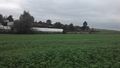
The Hashpoint

Sleepy Grin


Achievements
RecentlyChanged earned the Land geohash achievement
|
RecentlyChanged achieved level 4 of the Minesweeper Geohash achievement
|