Difference between revisions of "2013-10-27 48 9"
From Geohashing
imported>Knallgöwer ([live picture] Beautiful autumn afternoon in the forest! [http://www.openstreetmap.org/?lat=48.78614912&lon=9.09818972&zoom=16&layers=B000FTF @48.7861,9.0982]) |
imported>FippeBot m (Location) |
||
| (6 intermediate revisions by 2 users not shown) | |||
| Line 44: | Line 44: | ||
Image:2013-10-27_48_9_12-24-21-669.jpg | Beautiful autumn afternoon in the forest! [http://www.openstreetmap.org/?lat=48.78614912&lon=9.09818972&zoom=16&layers=B000FTF @48.7861,9.0982] | Image:2013-10-27_48_9_12-24-21-669.jpg | Beautiful autumn afternoon in the forest! [http://www.openstreetmap.org/?lat=48.78614912&lon=9.09818972&zoom=16&layers=B000FTF @48.7861,9.0982] | ||
| + | |||
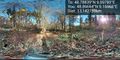
| + | Image:2013-10-27_48_9_13-19-00-324.jpg | There! Reaching the hash at 12:31! | ||
| + | |||
| + | Image:2013-10-27_48_9_13-20-02-772.jpg | Nearby Castle Solitude [http://www.openstreetmap.org/?lat=48.78677454&lon=9.08482561&zoom=16&layers=B000FTF @48.7868,9.0848] | ||
| + | |||
| + | Image:2013-10-27_48_9_13-20-53-658.jpg | Castle Solitude close to the hashpoint! [http://www.openstreetmap.org/?lat=48.78676972&lon=9.08482763&zoom=16&layers=B000FTF @48.7868,9.0848] | ||
| + | |||
| + | Image:2013-10-27_48_9_13-22-04-996.jpg | View from Solitude [http://www.openstreetmap.org/?lat=48.78676288&lon=9.08483344&zoom=16&layers=B000FTF @48.7868,9.0848] | ||
| + | |||
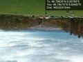
| + | Image:2013-10-27_48_9_16-57-18-419.jpg | Panorama picture of the hashpoint | ||
</gallery> | </gallery> | ||
| Line 51: | Line 61: | ||
| − | |||
| − | |||
| − | |||
| − | |||
| − | |||
| − | |||
| − | |||
| − | |||
| − | |||
[[Category:Expeditions]] | [[Category:Expeditions]] | ||
| − | |||
[[Category:Expeditions with photos]] | [[Category:Expeditions with photos]] | ||
| − | |||
| − | |||
| − | |||
| − | |||
| − | |||
[[Category:Coordinates reached]] | [[Category:Coordinates reached]] | ||
| − | + | {{location|DE|BW|S}} | |
| − | |||
| − | |||
| − | |||
| − | |||
| − | |||
| − | |||
| − | |||
| − | |||
| − | |||
| − | |||
| − | |||
| − | |||
| − | |||
| − | |||
| − | |||
| − | |||
| − | |||
Latest revision as of 04:28, 14 August 2019
| Sun 27 Oct 2013 in 48,9: 48.7883884, 9.0978016 geohashing.info google osm bing/os kml crox |
Location
Participants
Plans
Expedition
- Comin... -- Knallgöwer (talk) 11:17, 27 October 2013 (CET)
- Getting close to the hash near Castle Solitude -- Knallgöwer (talk) @48.7855,9.0982 12:23, 27 October 2013 (CET)
Tracklog
Photos
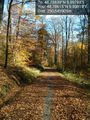
Beautiful autumn afternoon in the forest! @48.7861,9.0982
There! Reaching the hash at 12:31!
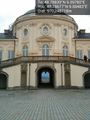
Nearby Castle Solitude @48.7868,9.0848
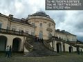
Castle Solitude close to the hashpoint! @48.7868,9.0848
View from Solitude @48.7868,9.0848
Panorama picture of the hashpoint


