Difference between revisions of "2013-10-31 43 -116"
imported>Eldin (create initial report.) |
imported>FippeBot m (Location) |
||
| (One intermediate revision by one other user not shown) | |||
| Line 1: | Line 1: | ||
| − | + | [[Image:2013-10-31_43_-116_rainbow.jpg|thumb|left]] | |
| − | |||
| − | |||
| − | [[Image: | ||
| − | |||
| − | |||
| − | |||
| − | |||
| − | |||
| − | |||
{{meetup graticule | {{meetup graticule | ||
| lat=43 | | lat=43 | ||
| Line 15: | Line 6: | ||
}} | }} | ||
| − | |||
__NOTOC__ | __NOTOC__ | ||
| Line 24: | Line 14: | ||
*[[User:Eldin|Eldin]] | *[[User:Eldin|Eldin]] | ||
* Pojana | * Pojana | ||
| − | |||
| − | |||
| − | |||
== Expedition == | == Expedition == | ||
| Line 34: | Line 21: | ||
== Photos == | == Photos == | ||
| − | |||
| − | |||
| − | |||
<gallery perrow="5"> | <gallery perrow="5"> | ||
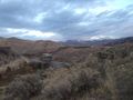
| + | File:2013-10-31_43_-116_rainbow.jpg | The coordinates were almost directly between us and the end of the rainbow. | ||
| + | File:2013-10-31 43 -116 grin.jpg | Grinning geohashers. | ||
| + | File:2013-10-31 43 -116 proof.jpg | Proof that we reached the coordinates. | ||
| + | File:2013-10-31 43 -116 spot.jpg | Pojana showing the exact spot. | ||
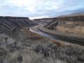
| + | File:2013-10-31 43 -116 view1.jpg | Looking across the canyon. The hash was just a bit up from the top of a similar cliff to the one pictured here. | ||
| + | File:2013-10-31 43 -116 view2.jpg | The view towards the dam. | ||
| + | File:2013-10-31 43 -116 view3.jpg | And looking back towards town. | ||
</gallery> | </gallery> | ||
| Line 44: | Line 35: | ||
{{Land geohash|latitude=43|longitude=-116|date=2013-10-31|name=[[User:Eldin|Eldin]] & Pojana}} | {{Land geohash|latitude=43|longitude=-116|date=2013-10-31|name=[[User:Eldin|Eldin]] & Pojana}} | ||
| − | |||
| − | |||
| − | |||
| − | |||
| − | |||
| − | |||
| − | |||
| − | |||
| − | |||
| − | |||
[[Category:Expeditions]] | [[Category:Expeditions]] | ||
| − | |||
[[Category:Expeditions with photos]] | [[Category:Expeditions with photos]] | ||
| − | |||
| − | |||
| − | |||
| − | |||
| − | |||
[[Category:Coordinates reached]] | [[Category:Coordinates reached]] | ||
| − | + | {{location|US|ID|AA}} | |
| − | |||
| − | |||
| − | |||
| − | |||
| − | |||
| − | |||
| − | |||
| − | |||
| − | |||
| − | |||
| − | |||
| − | |||
| − | |||
| − | |||
| − | |||
| − | |||
| − | |||
Latest revision as of 04:30, 14 August 2019

| Thu 31 Oct 2013 in 43,-116: 43.5231714, -116.0683679 geohashing.info google osm bing/os kml crox |
Location
On the rim of the Boise River canyon, just downstream from Lucky Peak dam.
Participants
- Eldin
- Pojana
Expedition
Paved roads got us to within a mile or so of the hash. Then it was primitive roads from there on. One of the roads we tried ended in a dead end about 1900ft from the hash, at which point we got out and walked for about 10 minutes before realizing the hash was on the far side of a difficult-to-pass wash. So we walked back to the car and found another drivable trail leading in the right direction. The trail was narrow, and in a few places had one side of the car a foot or more higher than the other where it cut around the end of the wash that stopped our first walk, but eventually it got us to within 1000ft of the hash. When we parked the car, we saw that the hash was almost directly between us and the end of a rainbow. We walked the rest of the way to the coordinates and took some pictures. Then I walked the last 50ft or so to where the slope started to get steep towards the canyon rim, and took more pictures. The view was impressive. I've driven through the canyon many times, but never seen it from up on the rim before. All in all, a very enjoyable hash, even if it did rain on us a bit.
Photos
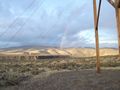
The coordinates were almost directly between us and the end of the rainbow.

Grinning geohashers.
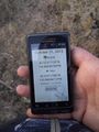
Proof that we reached the coordinates.
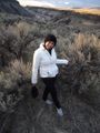
Pojana showing the exact spot.
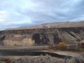
Looking across the canyon. The hash was just a bit up from the top of a similar cliff to the one pictured here.
The view towards the dam.
And looking back towards town.


Achievements
Eldin & Pojana earned the Land geohash achievement
|