Difference between revisions of "2013-11-10 59 17"
From Geohashing
imported>DLichti |
(→Achievements) |
||
| (3 intermediate revisions by 3 users not shown) | |||
| Line 1: | Line 1: | ||
[[Image:{{{image|2013-11-10_59_17_xkcd.jpg}}}|thumb|left]] | [[Image:{{{image|2013-11-10_59_17_xkcd.jpg}}}|thumb|left]] | ||
| − | |||
| − | |||
| − | |||
| − | |||
| − | |||
| − | |||
| − | |||
| − | |||
{{meetup graticule | {{meetup graticule | ||
| lat=59 | | lat=59 | ||
| Line 22: | Line 14: | ||
== Participants == | == Participants == | ||
[[User:DLichti|DLichti]] | [[User:DLichti|DLichti]] | ||
| − | |||
| − | |||
== Expedition == | == Expedition == | ||
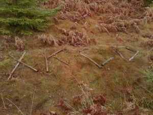
After a half hour bus ride, I walked the remaining 2km to the hash point. Most of it was on a unpaved road, so, apart from some muddy parts, it went rather well. The last 100m were through the forest untill I found the hash point on a clearance at around 14:30. I wrote "xkcd" on the ground using some dead branches, took some pictures and went back to the bus stop to get the next bus before it got dark. | After a half hour bus ride, I walked the remaining 2km to the hash point. Most of it was on a unpaved road, so, apart from some muddy parts, it went rather well. The last 100m were through the forest untill I found the hash point on a clearance at around 14:30. I wrote "xkcd" on the ground using some dead branches, took some pictures and went back to the bus stop to get the next bus before it got dark. | ||
| − | |||
| − | |||
| − | |||
== Photos == | == Photos == | ||
| Line 41: | Line 28: | ||
== Achievements == | == Achievements == | ||
{{#vardefine:ribbonwidth|800px}} | {{#vardefine:ribbonwidth|800px}} | ||
| − | + | ||
| + | {{Public transport geohash | ||
| + | | latitude = 59 | ||
| + | | longitude = 17 | ||
| + | | date = 2013-11-10 | ||
| + | | busline = SL's Buss 783 | ||
| + | | name = DLichti | ||
| + | }} | ||
[[Category:Expeditions]] | [[Category:Expeditions]] | ||
[[Category:Coordinates reached]] | [[Category:Coordinates reached]] | ||
[[Category:Expeditions with photos]] | [[Category:Expeditions with photos]] | ||
| − | + | {{location|SE|AB}} | |
| − | |||
| − | |||
| − | |||
| − | |||
| − | |||
| − | |||
| − | |||
| − | |||
| − | |||
Latest revision as of 07:33, 25 May 2024
| Sun 10 Nov 2013 in 59,17: 59.0623886, 17.8278696 geohashing.info google osm bing/os kml crox |
Location
In the woods close to Åvik in Nynäshamns kommun.
Participants
Expedition
After a half hour bus ride, I walked the remaining 2km to the hash point. Most of it was on a unpaved road, so, apart from some muddy parts, it went rather well. The last 100m were through the forest untill I found the hash point on a clearance at around 14:30. I wrote "xkcd" on the ground using some dead branches, took some pictures and went back to the bus stop to get the next bus before it got dark.
Photos
Achievements
DLichti earned the Public transport geohash achievement
|


