Difference between revisions of "2013-12-01 42 -113"
imported>Eldin (create initial expedition report.) |
m (per Renaming Proposal) |
||
| (2 intermediate revisions by 2 users not shown) | |||
| Line 1: | Line 1: | ||
| − | |||
| − | |||
| − | |||
| − | |||
| − | |||
| − | |||
| − | |||
| − | |||
| − | |||
| − | |||
{{meetup graticule | {{meetup graticule | ||
| lat=42 | | lat=42 | ||
| Line 15: | Line 5: | ||
}} | }} | ||
| − | |||
__NOTOC__ | __NOTOC__ | ||
| Line 33: | Line 22: | ||
== Photos == | == Photos == | ||
| − | |||
| − | |||
| − | |||
<gallery perrow="5"> | <gallery perrow="5"> | ||
| + | File:2013-12-01 42 -113 proof.jpg | Proof of reaching the spot. | ||
| + | File:2013-12-01 42 -113 grin.jpg | Grin. | ||
| + | File:2013-12-01 42 -113 view1.jpg | View to the south. | ||
| + | File:2013-12-01 42 -113 view2.jpg | View to the east. | ||
| + | File:2013-12-01 42 -113 view3.jpg | View to the north. | ||
| + | File:2013-12-01 42 -113 view4.jpg | The hill northwest of the hash. | ||
</gallery> | </gallery> | ||
| Line 42: | Line 34: | ||
{{#vardefine:ribbonwidth|800px}} | {{#vardefine:ribbonwidth|800px}} | ||
{{Land geohash|latitude=42|longitude=-113|date=2013-12-01|name=[[User:Eldin|Eldin]]}} | {{Land geohash|latitude=42|longitude=-113|date=2013-12-01|name=[[User:Eldin|Eldin]]}} | ||
| − | {{ | + | {{Graticule unlocked|latitude=42|longitude=-113|date=2013-12-01|name=[[User:Eldin|Eldin]]}} |
| − | |||
| − | |||
| − | |||
| − | |||
| − | |||
| − | |||
| − | |||
| − | |||
| − | |||
| − | |||
[[Category:Expeditions]] | [[Category:Expeditions]] | ||
| − | |||
[[Category:Expeditions with photos]] | [[Category:Expeditions with photos]] | ||
| − | |||
| − | |||
| − | |||
| − | |||
| − | |||
[[Category:Coordinates reached]] | [[Category:Coordinates reached]] | ||
| − | + | {{location|US|ID|CS}} | |
| − | |||
| − | |||
| − | |||
| − | |||
| − | |||
| − | |||
| − | |||
| − | |||
| − | |||
| − | |||
| − | |||
| − | |||
| − | |||
| − | |||
| − | |||
| − | |||
| − | |||
Latest revision as of 05:17, 20 March 2024
| Sun 1 Dec 2013 in 42,-113: 42.1642204, -113.3904929 geohashing.info google osm bing/os kml crox |
Location
In the desert south of Malta
Participants
Plans
The hash was close enough to my route coming home from visiting family that I wanted to try to stop on the way and get it.
Expedition
In order to pass near the hash, I took the old US-30 route instead of the Interstate from Snowville to Burley. About 3 miles from the hash I pulled off on a gravel road that led the right direction. This led to a dirt road, which led to a road that was nothing more than a couple of ruts. As I progressed the last 2 miles from the hash, the ruts became progressively less distinct and the vegetation growing between them taller. Eventually, I got as close as my car was going to get. I still had about 3700 ft (~0.75 miles) to go. So I pulled the car off the side of the track and set off walking. It was a fairly easy 1.5 mile walk to get to the hash from there. My wife elected to stay in the car, as it was a bit cold out. I got to the spot, took some photos, and walked back to the car. It took me about half an hour round trip to walk it.
Photos
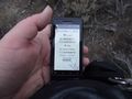
Proof of reaching the spot.

Grin.
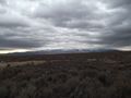
View to the south.
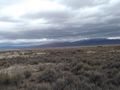
View to the east.
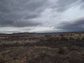
View to the north.
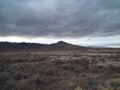
The hill northwest of the hash.


Achievements
Eldin earned the Land geohash achievement
|
Eldin earned the Graticule Unlocked Achievement
|